METAR & TAF 6G8
6G8 does not publish a METAR.
Showing the nearest reporting station: KJXN (JACKSON COUNTY/REYNOLDS FLD) · 14.0 NM away. Conditions at 6G8 may differ.
METAR · KJXN
Observed 16:56Z
KJXN 271656Z 24007G14KT 10SM CLR 27/19 A2979 RMK AO2 PRESFR SLP080 T02720194
- Wind
- 240° @ 7G14 kt
- Visibility
- 10 SM
- Temp / Dew
- 27°C / 19°C
- Altimeter
- 29.79 inHg
- Clouds
- CLR
- Density alt
- 2,818 ft
- Ceiling
- Unlimited
- Rules
- VFR
Airport info & contacts
Manager on record, flight service, ARTCC, attendance schedule and pattern altitude — published by the FAA and refreshed every 28 days.
Location
- From city
- 1 NM SE
- VFR sectional
- DETROIT
- ARTCC
- ZOB · CLEVELAND
- NOTAM facility
- LAN (NOTAM-D)
Airport manager
- Name
- CRAIG PEARSON
- Phone
- 586-646-8199
- Address
- PO BOX 324, BROOKLYN MI 49230-0324
Flight service · Hours
- FSS LAN
- LANSING1-800-WX-BRIEF
- Attendance
- IREG
Frequencies
Tap any row to copy the frequency to your clipboard.
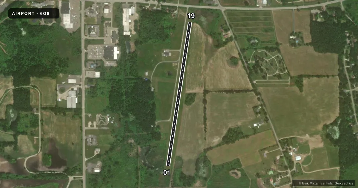
Runways & pattern
Full pagePattern entry · RWY 19
LEFT TRAFFICRunway end performance
| End | TORA | TODA | ASDA | LDA | VGSI | Approach lights | Obstruction |
|---|---|---|---|---|---|---|---|
| 01 | — | — | — | — | — | — | 32', tree, 44' from thr, 107' R of cntrln, slope 1 |
| 19 | — | — | — | — | — | — | 55', trees, 435' from thr, 140' R of cntrln, slope 7 |
Declared distances in feet. TORA = takeoff run available, TODA = takeoff distance, ASDA = accelerate-stop, LDA = landing distance.
Airport sketch
Runways drawn to scale from FAA survey coordinates, rendered over satellite imagery. Not for navigation.
Approaches & charts
Services on the field
Fuel grades, oxygen, maintenance, ramp storage and lighting — as declared to the FAA by the airport operator.
Fuel & services
- Fuel
- Not available
- Other services
- INSTR,SALES
Ramp & ground
- Transient storage
- Tie-down
- Hangar
- Landing fee
- No fee published
- Lighting schedule
- SEE RMK
- Wind indicator
- Lighted
- Segmented circle
- Yes
Fuel & FBOs
Cheapest 100LL and Jet A on the field and nearby. Always confirm with the FBO before taxi.
Airport notes
Surface conditions, obstructions, local procedures, lighting outages and other notes published with each FAA cycle.
General notes
- 105 FT MKD PLINE & TWR, 0.25 NM FM RWY 19 THR, EXTDD L & R OF CNTRLN.
- DEER & LRG BIRDS ON & INVOF ARPT.
- ADMIN BLDG ACES 1-2-2-9.
- FOR CD CTC GREAT LAKES APCH AT 269-459-3345, WHEN APCH CLSD CTC CLEVELAND ARTCC AT 440-774-0229/0490.
- ARPT CLSD WHEN SNOW COVD EXC FOR SKI EQUIPPED ACFT.
Lighting notes
- LIRL RWY 01/19 OTS INDEFLY.
Approach & departure obstructions
- 013 FT YELLOW CONES.
- 19RWY & DTHR MKD WITH 3 FT YELLOW CONES.
Other notes
- PRKG & OVNGT FEE.
- OWNERRESIDES ON ARPT PREMISES.
VFR map & nearby airports
VFR sectional. Tap any ICAO chip to open that airport.
Key facts · 6G8
Answer card- ICAO
- 6G8
- Name
- BROOKLYN
- Location
- BROOKLYN, MICHIGAN
- Elevation
- 981 ft MSL
- Traffic pattern altitude
- 1,981 ft MSL (1,000 AGL)
- Control tower
- Non-towered (use CTAF)
- Total runways
- 1
- Longest runway
- 01/19 · 2,829 ft
- Published ILS approaches
- 0
- Published frequencies
- 1
- Magnetic variation
- 5°
- Current flight rules
- VFR
- Current wind
- 240° at 7 kt
- Favored runway now
- RWY 19
Brooklyn Airport (6G8) sits in Brooklyn, Michigan. The field elevation is 981 ft MSL. It has one runway. Runway 01/19 is 2,829 ft of turf, which makes this a short-field stop for light aircraft. There is no control tower. CTAF is 122.9.
No ILS approaches are published here. The pattern altitude is not published, so use standard 1,000 ft AGL for light piston traffic unless the current Chart Supplement says otherwise. Published remarks matter here. Low intensity runway lights for 01/19 are out of service indefinitely. The runway and displaced threshold are marked with 3-foot yellow cones. There is also a marked power line and tower about 0.25 NM from the runway 19 threshold. It is extended left and right of centerline. Deer and large birds are reported on and near the airport.
No on-field FBOs are listed. Check with the airport operator or the FBO directly by phone before arrival if you need fuel or services. The airport is closed when snow covered except for ski equipped aircraft. Parking and overnight fees are charged. For clearance delivery, contact Great Lakes Approach at 269-459-3345. When approach is closed, contact Cleveland ARTCC at 440-774-0229 or 440-774-0490. If you are planning a first visit, verify current runway condition, lighting status and any local procedures before you go.