METAR & TAF 6H4
6H4 does not publish a METAR.
Showing the nearest reporting station: KJXN (JACKSON COUNTY/REYNOLDS FLD) · 8.5 NM away. Conditions at 6H4 may differ.
METAR · KJXN
Observed 16:56Z
KJXN 271656Z 24007G14KT 10SM CLR 27/19 A2979 RMK AO2 PRESFR SLP080 T02720194
- Wind
- 240° @ 7G14 kt
- Visibility
- 10 SM
- Temp / Dew
- 27°C / 19°C
- Altimeter
- 29.79 inHg
- Clouds
- CLR
- Density alt
- 2,826 ft
- Ceiling
- Unlimited
- Rules
- VFR
Airport info & contacts
Manager on record, flight service, ARTCC, attendance schedule and pattern altitude — published by the FAA and refreshed every 28 days.
Location
- From city
- 5 NM W
- VFR sectional
- DETROIT
- ARTCC
- ZOB · CLEVELAND
- NOTAM facility
- LAN (NOTAM-D)
Airport manager
- Name
- BRIAN VAN WAGNEN
- Phone
- 517-764-4193
- Address
- 4253 SAUNT RD, JACKSON MI 49201-7225
Flight service · Hours
- FSS LAN
- LANSING1-800-WX-BRIEF
- Attendance
- ALL
Frequencies
Tap any row to copy the frequency to your clipboard.
Runways & pattern
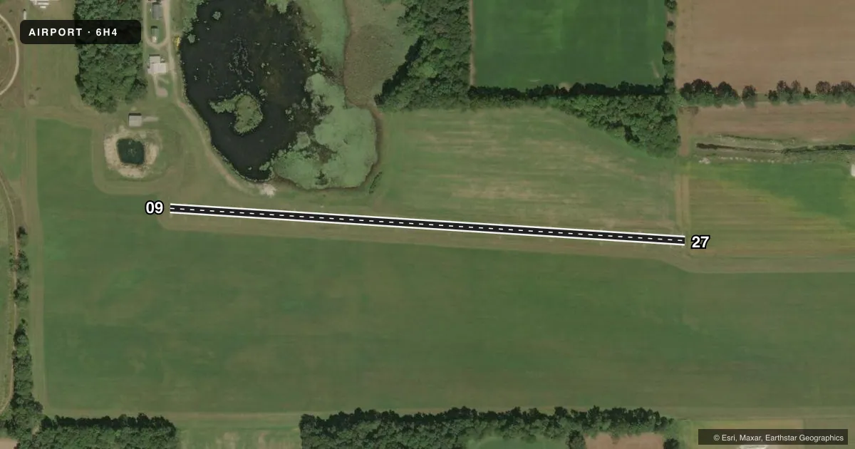
Full pagePattern entry · RWY 27
LEFT TRAFFICRunway end performance
| End | TORA | TODA | ASDA | LDA | VGSI | Approach lights | Obstruction |
|---|---|---|---|---|---|---|---|
| 09 | — | — | — | — | — | — | 50', trees, 595' from thr, 135' R of cntrln, slope 11 |
Declared distances in feet. TORA = takeoff run available, TODA = takeoff distance, ASDA = accelerate-stop, LDA = landing distance.
Airport sketch
Runways drawn to scale from FAA survey coordinates, rendered over satellite imagery. Not for navigation.
Approaches & charts
Services on the field
Fuel grades, oxygen, maintenance, ramp storage and lighting — as declared to the FAA by the airport operator.
Fuel & services
- Fuel
- Not available
Ramp & ground
- Transient storage
- Tie-down
- Wind indicator
- Yes
- Segmented circle
- No
Fuel & FBOs
Cheapest 100LL and Jet A on the field and nearby. Always confirm with the FBO before taxi.
Airport notes
Surface conditions, obstructions, local procedures, lighting outages and other notes published with each FAA cycle.
General notes
- SEASONAL 8 FT CROPS IN RWY 27 APCH.
- LRG BIRDS & DEER ON & INVOF ARPT.
- IREG SNOW REMOVAL SKED - CTC AMGR FOR RWY CONDS.
- 4 FT ELEC BOX, 50 FT NORTH OF RCL, 610 FT EAST OF RWY 09 THR.
- FOR CD CTC GREAT LAKES APCH AT 269-459-3345, WHEN APCH CLSD CTC CLEVELAND ARTCC AT 440-774-0224/0490.
- +300 FT TWY TO RWY 09 THR, MKD WITH 2 OUTBOARD YELLOW TIRES EACH SIDE.
Approach & departure obstructions
- 09YELLOW TIRES.
- 27YELLOW TIRES.
Other notes
- PRVDD AREA 125 FT EITHER SIDE OF RCL & 200 FT OFF RWY ENDS CLEAR OF OBSTNS IN RWY APCH SLP SFC; OBSTNS REMOVED/LWRD OR THR DSPLCD & MKD TO PRVD MNM 20:1 APCH CLNC OVR OBSTNS; AREA 60 FT EITHER SIDE OF RCL & 240 FT OFF RWY ENDS COMPLY WITH AC 150/5300-13 PARA 305.
VFR map & nearby airports
VFR sectional. Tap any ICAO chip to open that airport.
Key facts · 6H4
Answer card- ICAO
- 6H4
- Name
- VAN WAGNEN
- Location
- NAPOLEON, MICHIGAN
- Elevation
- 988 ft MSL
- Traffic pattern altitude
- 1,988 ft MSL (1,000 AGL)
- Control tower
- Non-towered (use CTAF)
- Total runways
- 1
- Longest runway
- 09/27 · 2,105 ft
- Published ILS approaches
- 0
- Published frequencies
- 1
- Magnetic variation
- 4°
- Current flight rules
- VFR
- Current wind
- 240° at 7 kt
- Favored runway now
- RWY 27
Van Wagnen (6H4) sits near Napoleon, Michigan. Field elevation is 988 ft MSL. The airport has one runway. Runway 09/27 is 2,105 ft long and turf. There is no control tower. CTAF is 122.9.
No ILS approaches are published here. Pattern altitude is not published, so use the standard 1,000 ft AGL for light piston traffic unless the current FAA Chart Supplement says otherwise. The field has published remarks that matter on a first visit. Taxi to runway 09 uses a 300 ft segment marked with yellow tires. There is also a 4 ft electrical box north of the runway centerline near the 09 end. Seasonal 8 ft crops can be in the runway 27 approach. Large birds and deer are reported on and near the airport. Snow removal is irregular, so runway condition should be checked with the airport manager before departure.
No on-field FBOs are listed. Plan on self-briefing the field and calling ahead if you need local condition updates. For clearance delivery, contact Great Lakes Approach when it is open. If approach is closed, contact Cleveland ARTCC. The runway environment is short, turf and exposed to wildlife and seasonal crop issues. A conservative performance check makes sense before you launch.