METAR & TAF 75G
75G does not publish a METAR.
Showing the nearest reporting station: KARB (ANN ARBOR MUNI) · 12.8 NM away. Conditions at 75G may differ.
METAR · KARB
Observed 17:53Z
KARB 271753Z 29009KT 10SM CLR 30/20 A2976 RMK AO2 SLPNO T03000200 $
- Wind
- 290° @ 9 kt
- Visibility
- 10 SM
- Temp / Dew
- 30°C / 20°C
- Altimeter
- 29.76 inHg
- Clouds
- CLR
- Density alt
- 3,245 ft
- Ceiling
- Unlimited
- Rules
- VFR
Airport info & contacts
Manager on record, flight service, ARTCC, attendance schedule and pattern altitude — published by the FAA and refreshed every 28 days.
Location
- From city
- 3 NM N
- VFR sectional
- DETROIT
- ARTCC
- ZOB · CLEVELAND
- NOTAM facility
- LAN (NOTAM-D)
Airport manager
- Name
- AUGUST M ROSSETTIE
- Phone
- 734-323-8766
- Address
- 8875 M 52, MANCHESTER MI 48158-9446
Flight service · Hours
- FSS LAN
- LANSING1-800-WX-BRIEF
- Attendance
- IREG
Frequencies
Tap any row to copy the frequency to your clipboard.
Runways & pattern
Full pagePattern entry · RWY 36
RIGHT TRAFFICRunway end performance
| End | TORA | TODA | ASDA | LDA | VGSI | Approach lights | Obstruction |
|---|---|---|---|---|---|---|---|
| 18 | — | — | — | — | — | — | 67', tree, 371' from thr, 150' R of cntrln, slope 5 |
| 36 | — | — | — | — | — | — | 12', road, 25' from thr, 128' R of cntrln, slope 2 |
Declared distances in feet. TORA = takeoff run available, TODA = takeoff distance, ASDA = accelerate-stop, LDA = landing distance.
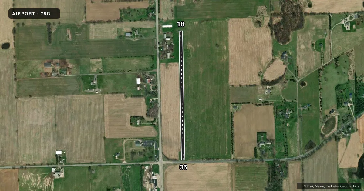
Airport sketch
Runways drawn to scale from FAA survey coordinates, rendered over satellite imagery. Not for navigation.
Approaches & charts
Services on the field
Fuel grades, oxygen, maintenance, ramp storage and lighting — as declared to the FAA by the airport operator.
Fuel & services
- Fuel
- UL94
- Oxygen (bottled)
- Not available
- Oxygen (bulk)
- Not available
- Airframe repair
- Not available
- Power plant repair
- Not available
Ramp & ground
- Transient storage
- Tie-down
- Landing fee
- No fee published
- Wind indicator
- Yes
- Segmented circle
- Yes
Fuel & FBOs
Cheapest 100LL and Jet A on the field and nearby. Always confirm with the FBO before taxi.
Airport notes
Surface conditions, obstructions, local procedures, lighting outages and other notes published with each FAA cycle.
General notes
- FOR CD CTC DETROIT APCH AT 734-955-1404.
- BIRDS & DEER ON & INVOF ARPT.
- FOR FLD CONDS DURG SNOW CTC AMGR.
- OPPOSITE RWY END NOT VSB FM THR DUE TO ROLLING TRRN.
Approach & departure obstructions
- 183 FT YELLOW CONES.
- 363 FT YELLOW CONES.
- 36APCH RATIO 8:1 TO DTHR; DTHR ELEV ESTD -9 FT BLW THR.
Other notes
- PRVDD VFR WX CONDS.
- 18/36ROLLING TRRN, SOFT IN SPRING.
VFR map & nearby airports
VFR sectional. Tap any ICAO chip to open that airport.
Key facts · 75G
Answer card- ICAO
- 75G
- Name
- ROSSETTIE
- Location
- MANCHESTER, MICHIGAN
- Elevation
- 1,005 ft MSL
- Traffic pattern altitude
- 2,005 ft MSL (1,000 AGL)
- Control tower
- Non-towered (use CTAF)
- Total runways
- 1
- Longest runway
- 18/36 · 2,480 ft
- Published ILS approaches
- 0
- Published frequencies
- 1
- Magnetic variation
- 5°
- Current flight rules
- VFR
- Current wind
- 290° at 9 kt
- Favored runway now
- RWY 36
Rossettie Airport (75G) sits in Manchester, Michigan. Field elevation is 1,005 ft MSL. It has one runway, 18/36, which is 2,480 ft of turf. The airport is non-towered. CTAF is 122.9. No ILS approaches are published here.
Pattern altitude is not published. Use the standard 1,000 ft AGL for light piston operations unless the current Chart Supplement says otherwise. That puts the pattern at 2,005 ft MSL based on the field elevation. Verify before you fly. The published remarks matter here. Runway 18 and runway 36 both have three-foot yellow cones marking the ends. The opposite runway end is not visible from the threshold because of rolling terrain. Runway 36 also has an approach note tied to a displaced threshold. The surface can get soft in spring. Birds and deer are also reported on and near the airport.
There are no on-field FBOs listed. For current field conditions, contact the airport manager, especially in snow. For clearance delivery, Detroit Approach is listed in the remarks. Pilots should plan for a turf strip with terrain effects, limited runway length and no published ILS support. Check the current FAA Chart Supplement before departure for any updated operational notes.