METAR & TAF KARB
Current METAR
Observed 18:53Z
KARB 271853Z 26008KT 10SM CLR 28/20 A2981 RMK AO2 SLPNO T02780200 $
- Wind
- 260° @ 8 kt
- Visibility
- 10 SM
- Temp / Dew
- 28°C / 20°C
- Altimeter
- 29.81 inHg
- Clouds
- CLR
- Density alt
- 2,737 ft
- Ceiling
- Unlimited
- Rules
- VFR
Airport info & contacts
Manager on record, flight service, ARTCC, attendance schedule and pattern altitude — published by the FAA and refreshed every 28 days.
Location
- From city
- 3 NM S
- VFR sectional
- DETROIT
- ARTCC
- ZOB · CLEVELAND
- NOTAM facility
- ARB (NOTAM-D)
Airport manager
- Name
- CARL KONOPASKA
- Phone
- 734-794-6312
- Address
- 801 AIRPORT DR, ANN ARBOR MI 48108-9703
Flight service · Hours
- FSS LAN
- LANSING1-800-WX-BRIEF
- Attendance
- APR-OCT · 0800-2000
- NOV-MAR · 0800-1800
Frequencies
Tap any row to copy the frequency to your clipboard.
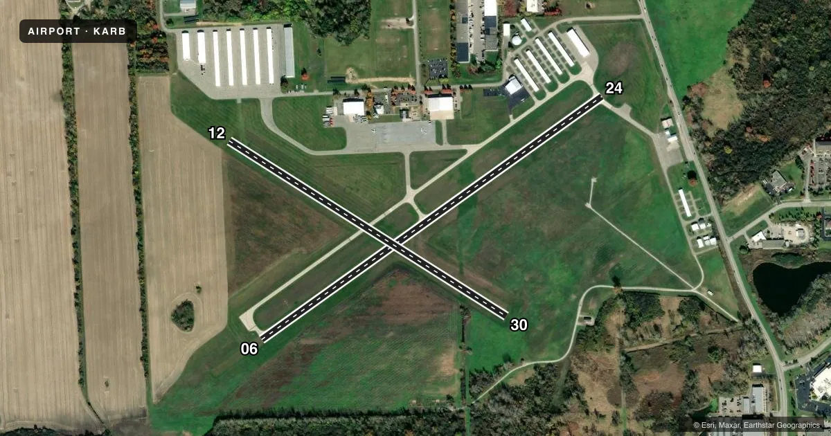
Runways & pattern
Full pagePattern entry · RWY 24
LEFT TRAFFIC| Runway | Heading (°M) | Length | Surface | Traffic |
|---|---|---|---|---|
| 06/24Favored | 50° / 230° | 3,505 ft | CONC | Standard L |
| 12/30 | 117° / 297° | 2,750 ft | TURF | Standard L |
Runway end performance
| End | TORA | TODA | ASDA | LDA | VGSI | Approach lights | Obstruction |
|---|---|---|---|---|---|---|---|
| 06 | — | — | — | — | PAPI 4-box left(3°) | — | — |
| 24 | — | — | — | — | VASI 2-box left(3°) | — | 74', tree, 1090' from thr, 389' R of cntrln, slope 12 |
| 30 | — | — | — | — | — | — | 83', tree, 1241' from thr, 255' R of cntrln, slope 14 |
Declared distances in feet. TORA = takeoff run available, TODA = takeoff distance, ASDA = accelerate-stop, LDA = landing distance.
Airport sketch
Runways drawn to scale from FAA survey coordinates, rendered over satellite imagery. Not for navigation.
Approaches & charts
Services on the field
Fuel grades, oxygen, maintenance, ramp storage and lighting — as declared to the FAA by the airport operator.
Fuel & services
- Fuel
- 100LLA+
- Oxygen (bottled)
- HIGH/LOW
- Oxygen (bulk)
- HIGH/LOW
- Airframe repair
- Major
- Power plant repair
- Major
- Other services
- INSTR,RNTL
Ramp & ground
- Transient storage
- Tie-down
- Hangar
- Customs
- Not available
- Lighting schedule
- SEE RMK
- Beacon schedule
- SS-SR
- Beacon
- White / Green (civil land)(WG)
- Wind indicator
- Lighted
- Segmented circle
- Yes
Fuel & FBOs
Cheapest 100LL and Jet A on the field and nearby. Always confirm with the FBO before taxi.
Airport notes
Surface conditions, obstructions, local procedures, lighting outages and other notes published with each FAA cycle.
General notes
- DEER & LRG BIRDS ON & INVOF ARPT.
- WHEN ATCT CLSD CONFIRM SNOW REMOVAL OPNS & WINTER CONDS - CTAF.
- RWY 24 RUNUP AREA FIRST 200 FT OF TWY A; TWY A1 BTN TWY A & RWY 24 HOLD LINE NOT VSB FM TWR.
- FOR CD WHEN ATCT IS CLSD CTC DETROIT APCH AT 734-955-1404.
- NO SNOW REMOVAL FOR RWY 12/30.
Lighting notes
- WHEN ATCT CLSD ACTVT REIL RWY 06; PAPI RWY 06; VASI RWY 24; MIRL RWY 06/24 - CTAF.
Approach & departure obstructions
- 123 FT YELLOW CONES.
Other notes
- 4TRML OPEN 0700-DUSK.
VFR map & nearby airports
VFR sectional. Tap any ICAO chip to open that airport.
Key facts · KARB
Answer card- ICAO
- KARB
- Name
- ANN ARBOR MUNI
- Location
- ANN ARBOR, MICHIGAN
- Elevation
- 839 ft MSL
- Traffic pattern altitude
- 1,839 ft MSL (1,000 AGL)
- Control tower
- Towered · 0800-2000
- Total runways
- 2
- Longest runway
- 06/24 · 3,505 ft
- Published ILS approaches
- 0
- Published frequencies
- 9
- Magnetic variation
- 5°
- Current flight rules
- VFR
- Current wind
- 260° at 8 kt
- Favored runway now
- RWY 24
Ann Arbor Muni sits in Ann Arbor, Michigan. The field elevation is 839 ft MSL. It has two runways. The longest is 06/24 at 3,505 ft on concrete. Runway 12/30 is turf at 2,750 ft. The tower is open 0800-2000. No ILS approaches are published here. Pattern altitude is not published, so use 1,000 ft AGL for light piston traffic unless the current FAA Chart Supplement says otherwise.
Two on-field FBOs are listed. Solo Aviation carries 100LL and Jet A. ACE Aviation Center also carries 100LL and Jet A. If you are planning a stop, call ahead for current ramp details and service status.
A few operational points matter here. When the tower is closed, runway lighting is activated on CTAF. The published remarks also note deer and large birds in the area. Runway 12 has yellow cones near it. Runway 24 uses the first 200 ft of taxiway A as the runup area. Taxiway A1 between taxiway A and the runway 24 hold line is not visible from the tower. There is no snow removal for runway 12/30. If you are arriving in winter, confirm conditions on CTAF before you go. For clearance delivery after tower hours, contact Detroit Approach directly.