METAR & TAF 43G
43G does not publish a METAR.
Showing the nearest reporting station: KYIP (WILLOW RUN) · 3.8 NM away. Conditions at 43G may differ.
METAR · KYIP
Observed 12:53Z
KYIP 271253Z 23009KT 8SM BKN043 BKN050 24/22 A2986 RMK AO2 SLP105 T02440217
- Wind
- 230° @ 9 kt
- Visibility
- 8 SM
- Temp / Dew
- 24°C / 22°C
- Altimeter
- 29.86 inHg
- Clouds
- BKN
- Density alt
- 2,016 ft
- Ceiling
- 4,300 ft AGL
- Rules
- VFR
Airport info & contacts
Manager on record, flight service, ARTCC, attendance schedule and pattern altitude — published by the FAA and refreshed every 28 days.
Location
- From city
- 3 NM SW
- VFR sectional
- DETROIT
- ARTCC
- ZOB · CLEVELAND
- NOTAM facility
- LAN (NOTAM-D)
Airport manager
- Name
- KENNEY FARMER
- Phone
- 313-218-3301
- Address
- 7790 RAWSONVILLE RD, BELLEVILLE MI 48111-2344
Flight service · Hours
- FSS LAN
- LANSING1-800-WX-BRIEF
- Attendance
- MON-FRI · 0900-1700
Frequencies
Tap any row to copy the frequency to your clipboard.
Runways & pattern
Full pagePattern entry · RWY 15
RIGHT TRAFFICRunway end performance
| End | TORA | TODA | ASDA | LDA | VGSI | Approach lights | Obstruction |
|---|---|---|---|---|---|---|---|
| 15 | — | — | — | — | — | — | 13', brush, 5' from thr, 50' R of cntrln, slope 0 |
| 33 | — | — | — | — | — | — | 15', road, 0' from thr, 60' R of cntrln, slope 0 |
Declared distances in feet. TORA = takeoff run available, TODA = takeoff distance, ASDA = accelerate-stop, LDA = landing distance.
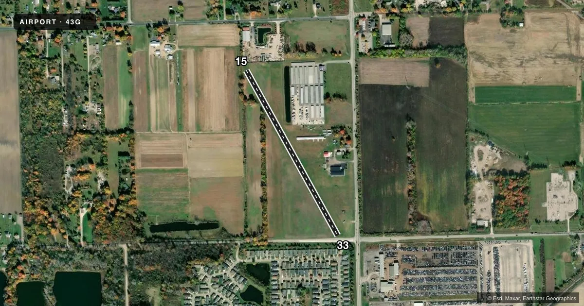
Airport sketch
Runways drawn to scale from FAA survey coordinates, rendered over satellite imagery. Not for navigation.
Approaches & charts
Services on the field
Fuel grades, oxygen, maintenance, ramp storage and lighting — as declared to the FAA by the airport operator.
Fuel & services
- Fuel
- Not available
- Oxygen (bottled)
- Not available
- Oxygen (bulk)
- Not available
- Airframe repair
- Not available
- Power plant repair
- Not available
Ramp & ground
- Transient storage
- Tie-down
- Landing fee
- No fee published
- Customs
- Not available
- Wind indicator
- Yes
- Segmented circle
- Yes
Fuel & FBOs
Cheapest 100LL and Jet A on the field and nearby. Always confirm with the FBO before taxi.
Airport notes
Surface conditions, obstructions, local procedures, lighting outages and other notes published with each FAA cycle.
General notes
- FLD CONDS SOFT DURG THAWING SEASON; VFY RWY/SNOW CONDS DURG WINTER OPS.
- FOR CD CTC DETROIT APCH AT 734-955-1404.
- DEER & LRG BIRDS ON & INVOF ARPT.
- PPR FOR N/S LDG AREA - CTC AMGR.
Approach & departure obstructions
- 15RWY & DTHR MKD WITH 3 FT YELLOW CONES.
- 33RWY & DTHR MKD WITH 3 FT YELLOW CONES.
- 15CTLG OBSTN EXCEEDS A 45 DEG SLP. APCH RATIO 20:1 TO DTHR.
- 33CTLG OBSTN EXCEEDS A 45 DEG SLP. APCH RATIO 17:1 TO DTHR OVR +44 FT TREE, 784 FT DIST, 55 FT R.
Other notes
- ESTABD BFR 1959.
VFR map & nearby airports
VFR sectional. Tap any ICAO chip to open that airport.
Key facts · 43G
Answer card- ICAO
- 43G
- Name
- BELLEVILLE
- Location
- BELLEVILLE, MICHIGAN
- Elevation
- 695 ft MSL
- Traffic pattern altitude
- 1,695 ft MSL (1,000 AGL)
- Control tower
- Non-towered (use CTAF)
- Total runways
- 1
- Longest runway
- 15/33 · 2,253 ft
- Published ILS approaches
- 0
- Published frequencies
- 1
- Magnetic variation
- 5°
- Current flight rules
- VFR
- Current wind
- 230° at 9 kt
- Favored runway now
- RWY 15
Belleville Airport is in Belleville, Michigan. The field elevation is 695 ft MSL. It has one runway, 15/33, which is 2,253 ft long and turf. There is no control tower. CTAF is 122.9. No ILS approaches are published here.
The published pattern altitude is not listed, so use the standard 1,000 ft AGL for light piston operations unless the current FAA Chart Supplement says otherwise. That puts the pattern at 1,695 ft MSL based on the field elevation. The airport has no on-field FBOs listed. Check with the airport operator before you go if you need local services.
The remarks matter here. Runway and displaced threshold markers use 3 ft yellow cones. Deer and large birds are reported on and near the airport. The field can be soft during thawing season, so verify runway and snow conditions before a winter or shoulder-season arrival. There is also a published note that prior permission is required for the north/south landing area. Contact the airport manager before planning that operation. For clearance delivery, Detroit Approach is listed in the remarks. This is a small turf field with no tower, so plan your arrival carefully and confirm current field conditions before you launch.