METAR & TAF KONZ
Current METAR
Observed 20:55Z
KONZ 272055Z AUTO 27009G16KT 10SM FEW100 29/20 A2979 RMK AO2
- Wind
- 270° @ 9G16 kt
- Visibility
- 10 SM
- Temp / Dew
- 29°C / 20°C
- Altimeter
- 29.79 inHg
- Clouds
- FEW
- Density alt
- 2,573 ft
- Ceiling
- Unlimited
- Rules
- VFR
Airport info & contacts
Manager on record, flight service, ARTCC, attendance schedule and pattern altitude — published by the FAA and refreshed every 28 days.
Location
- From city
- 2 NM S
- VFR sectional
- DETROIT
- ARTCC
- ZOB · CLEVELAND
- NOTAM facility
- ONZ (NOTAM-D)
Airport manager
- Name
- JANEL MACNEE
- Phone
- 734-675-0155
- Address
- P.O. BOX 129, PO BOX 129, GROSSE ILE MI 48138
Flight service · Hours
- FSS LAN
- LANSING1-800-WX-BRIEF
- Attendance
- MON-FRI · 0800-1800
- SAT-SUN · PRIOR ARNGMT
Frequencies
Tap any row to copy the frequency to your clipboard.
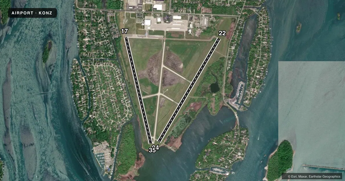
Runways & pattern
Full pagePattern entry · RWY 22
LEFT TRAFFIC| Runway | Heading (°M) | Length | Surface | Traffic |
|---|---|---|---|---|
| 04/22Favored | 23° / 203° | 4,846 ft | ASPH | 04 R |
| 17/35 | 160° / 340° | 4,424 ft | CONC | 35 R |
Runway end performance
| End | TORA | TODA | ASDA | LDA | VGSI | Approach lights | Obstruction |
|---|---|---|---|---|---|---|---|
| 04 | — | — | — | — | PAPI 4-box left(3.04°) | — | 37', tree, 790' from thr, 308' R of cntrln, slope 15 |
| 22 | — | — | — | — | PAPI 4-box left(3.04°) | — | 65', trees, 1010' from thr, 344' R of cntrln, slope 12 |
| 17 | — | — | — | — | PAPI 4-box left(3°) | — | 80', trees, 1180' from thr, 40' R of cntrln, slope 12 |
| 35 | — | — | — | — | PAPI 4-box left(3°) | — | — |
Declared distances in feet. TORA = takeoff run available, TODA = takeoff distance, ASDA = accelerate-stop, LDA = landing distance.
Airport sketch
Runways drawn to scale from FAA survey coordinates, rendered over satellite imagery. Not for navigation.
Approaches & charts
Services on the field
Fuel grades, oxygen, maintenance, ramp storage and lighting — as declared to the FAA by the airport operator.
Fuel & services
- Fuel
- 100LLA
- Oxygen (bottled)
- Not available
- Oxygen (bulk)
- Not available
- Airframe repair
- Major
- Power plant repair
- Major
- Other services
- CHTR,INSTR,RNTL
Ramp & ground
- Transient storage
- Tie-down
- Hangar
- Landing fee
- No fee published
- Customs
- Not available
- Lighting schedule
- SEE RMK
- Beacon schedule
- SS-SR
- Beacon
- White / Green (civil land)(WG)
- Wind indicator
- Lighted
- Segmented circle
- Yes
Fuel & FBOs
Cheapest 100LL and Jet A on the field and nearby. Always confirm with the FBO before taxi.
Airport notes
Surface conditions, obstructions, local procedures, lighting outages and other notes published with each FAA cycle.
General notes
- BIRDS & DEER ON & INVOF ARPT.
- ULTRALIGHT & PWRD PRCHT ACT INVOF ARPT.
- FOR CD CTC DETROIT APCH AT 734-955-1404.
Lighting notes
- ACTVT REIL RWY 04 & 22; PAPI RWY 04, 22, 17, & 35; MIRL RWY 04/22 & 17/35 - CTAF.
Approach & departure obstructions
- 22APCH RATIO 20:1 TO DTHR.
Other notes
- ARPT CLSD TO ACR OPS GTR THAN 30 PAX SEATS EXC PPR CALL AMGR.
- 17/35EXTSV PEELING & CRACKING - FOD HAZ.
VFR map & nearby airports
VFR sectional. Tap any ICAO chip to open that airport.
Key facts · KONZ
Answer card- ICAO
- KONZ
- Name
- GROSSE ILE MUNI
- Location
- DETROIT/GROSSE ILE, MICHIGAN
- Elevation
- 590.5 ft MSL
- Traffic pattern altitude
- 1,590.5 ft MSL (1,000 AGL)
- Control tower
- Non-towered (use CTAF)
- Total runways
- 2
- Longest runway
- 04/22 · 4,846 ft
- Published ILS approaches
- 0
- Published frequencies
- 4
- Magnetic variation
- 7°
- Current flight rules
- VFR
- Current wind
- 270° at 9 kt
- Favored runway now
- RWY 22
Grosse Ile Muni sits in Detroit/Grosse Ile, Michigan. Field elevation is 590.5 ft MSL. The airport has two runways. The longest is 4,846 ft on 04/22. There is no control tower. No ILS approaches are published. Pattern altitude is not published. Use standard 1,000 ft AGL for light piston traffic unless ATC or the current Chart Supplement says otherwise.
The on-field FBO is Grosse Ile Municipal Airport. It carries 100LL and Jet A. Call the field directly at (734) 675-0155 for current service details. Detroit Approach handles clearance delivery. The published remarks also flag birds and deer on and near the airport. Ultralight and powered parachute activity also occurs nearby. That matters here.
Runway 17/35 is 4,424 ft concrete. The Chart Supplement notes extensive peeling and cracking on that surface. Treat it as a possible FOD issue. Runway 22 has a displaced threshold with a steep approach slope to that threshold. Runway end identifier lights are active on 04 and 22. PAPI is available on both runways. Medium intensity runway lights are pilot-controlled on CTAF. This is a field where a careful preflight and a clean scan on rollout pay off.