METAR & TAF KTTF
Current METAR
Observed 13:35Z
KTTF 271335Z AUTO 24010KT 10SM FEW045 26/22 A2987 RMK AO2
- Wind
- 240° @ 10 kt
- Visibility
- 10 SM
- Temp / Dew
- 26°C / 22°C
- Altimeter
- 29.87 inHg
- Clouds
- FEW
- Density alt
- 2,145 ft
- Ceiling
- Unlimited
- Rules
- VFR
Airport info & contacts
Manager on record, flight service, ARTCC, attendance schedule and pattern altitude — published by the FAA and refreshed every 28 days.
Location
- From city
- 2 NM NW
- VFR sectional
- DETROIT
- ARTCC
- ZOB · CLEVELAND
- NOTAM facility
- TTF (NOTAM-D)
Airport manager
- Name
- CHRISTOPHER SCHAFFER
- Phone
- 734-384-9167
- Address
- 2800 N CUSTER RD, MONROE MI 48162-3537
Flight service · Hours
- FSS LAN
- LANSING1-800-WX-BRIEF
- Attendance
- IREG
Frequencies
Tap any row to copy the frequency to your clipboard.
Runways & pattern
Full pagePattern entry · RWY 21
LEFT TRAFFICRunway end performance
| End | TORA | TODA | ASDA | LDA | VGSI | Approach lights | Obstruction |
|---|---|---|---|---|---|---|---|
| 03 | — | — | — | — | VASI 2-box left(4°) | — | 70', tree, 1445' from thr, 355' R of cntrln, slope 17 |
| 21 | — | — | — | — | PAPI 2-box left(3.5°) | — | — |
Declared distances in feet. TORA = takeoff run available, TODA = takeoff distance, ASDA = accelerate-stop, LDA = landing distance.
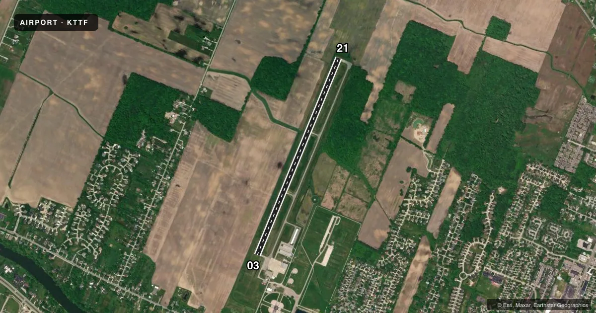
Airport sketch
Runways drawn to scale from FAA survey coordinates, rendered over satellite imagery. Not for navigation.
Approaches & charts
Services on the field
Fuel grades, oxygen, maintenance, ramp storage and lighting — as declared to the FAA by the airport operator.
Fuel & services
- Fuel
- 100LL
- Oxygen (bottled)
- Not available
- Oxygen (bulk)
- Not available
- Airframe repair
- Major
- Power plant repair
- Major
Ramp & ground
- Transient storage
- Tie-down
- Hangar
- Landing fee
- No fee published
- Customs
- Not available
- Lighting schedule
- SEE RMK
- Beacon schedule
- SS-SR
- Beacon
- White / Green (civil land)(WG)
- Wind indicator
- Lighted
- Segmented circle
- No
Fuel & FBOs
Cheapest 100LL and Jet A on the field and nearby. Always confirm with the FBO before taxi.
Airport notes
Surface conditions, obstructions, local procedures, lighting outages and other notes published with each FAA cycle.
General notes
- DEER & LRG BIRDS ON & INVOF ARPT.
- NOISE SENSITIVE AREAS. DEP ACFT MAX RATE OF CLIMB TO TPA.
- FOR CD CTC DETROIT APCH AT 734-955-1404.
- CTC AMGR TO VFY FICONS.
Lighting notes
- ACTVT VASI RWY 03; PAPI RWY 21; REIL RWY 21; MIRL RWY 03/21 - CTAF.
Approach & departure obstructions
- 038 FT SEASONAL CROPS, 200 FT DIST.
Other notes
- THIS AIRPORT HAS BEEN SURVEYED BY THE NATIONAL GEODETIC SURVEY.
- MANAGERCELL 734-777-9169.
VFR map & nearby airports
VFR sectional. Tap any ICAO chip to open that airport.
Key facts · KTTF
Answer card- ICAO
- KTTF
- Name
- CUSTER
- Location
- MONROE, MICHIGAN
- Elevation
- 615.6 ft MSL
- Traffic pattern altitude
- 1,615.6 ft MSL (1,000 AGL)
- Control tower
- Non-towered (use CTAF)
- Total runways
- 1
- Longest runway
- 03/21 · 4,997 ft
- Published ILS approaches
- 0
- Published frequencies
- 4
- Magnetic variation
- 5°
- Current flight rules
- VFR
- Current wind
- 240° at 10 kt
- Favored runway now
- RWY 21
Custer Airport sits in Monroe, Michigan. Field elevation is 615.6 ft MSL. The airport has one runway. Runway 03/21 is 4,997 ft long with asphalt pavement. There is no control tower. No ILS approaches are published. Pattern altitude is not published, so plan on the standard 1,000 ft AGL for light piston operations unless the current Chart Supplement says otherwise.
Monroe Aviation is the on-field FBO. It carries AVGAS 100LL. Call them at (734) 384-9616 before arrival if you need current ramp or fuel details. The airport remarks also note that noise-sensitive areas are present. Departing aircraft should use maximum rate of climb to traffic pattern altitude. Deer and large birds are also reported on and near the field, so keep a sharp scan on departure and arrival. There are 8-foot seasonal crops 200 feet from runway 03, which matters if you are operating that end.
Lighting is available on both ends. VASI is activated on runway 03. PAPI and REIL are activated on runway 21. Medium intensity runway lights on 03 and 21 are activated via CTAF. For clearance delivery, contact Detroit Approach. If you are new to the field, verify current conditions with the airport manager before you go. This is an uncontrolled airport with Detroit area approach frequencies in use, so stay ahead of the radio work and expect local traffic.