METAR & TAF KDTW
Current METAR
Observed 19:53Z
KDTW 271953Z 28012KT 10SM FEW040 OVC180 28/19 A2980 RMK AO2 SLP085 T02830194
- Wind
- 280° @ 12 kt
- Visibility
- 10 SM
- Temp / Dew
- 28°C / 19°C
- Altimeter
- 29.80 inHg
- Clouds
- OVC
- Density alt
- 2,509 ft
- Ceiling
- 18,000 ft AGL
- Rules
- VFR
Airport info & contacts
Manager on record, flight service, ARTCC, attendance schedule and pattern altitude — published by the FAA and refreshed every 28 days.
Location
- From city
- 15 NM S
- VFR sectional
- DETROIT
- ARTCC
- ZOB · CLEVELAND
- NOTAM facility
- DTW (NOTAM-D)
Airport manager
- Name
- CHAD NEWTON
- Phone
- 734-942-3685
- Address
- 11050 ROGELL DR #602, DETROIT MI 48242-1144
Flight service · Hours
- FSS LAN
- LANSING1-800-WX-BRIEF
- Attendance
- ALL
Frequencies
Tap any row to copy the frequency to your clipboard.
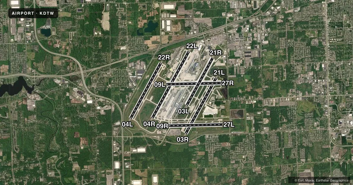
Runways & pattern
Full pagePattern entry · RWY 27R
LEFT TRAFFIC| Runway | Heading (°M) | Length | Surface | Traffic |
|---|---|---|---|---|
| 04R/22L | 22° / 202° | 12,003 ft | CONC | Standard L |
| 03R/21L | 22° / 202° | 10,001 ft | CONC | Standard L |
| 04L/22R | 22° / 202° | 10,000 ft | CONC | Standard L |
| 09L/27RFavored | 82° / 262° | 8,708 ft | CONC | Standard L |
| 03L/21R | 22° / 202° | 8,501 ft | CONC | Standard L |
| 09R/27L | 82° / 262° | 8,500 ft | CONC | Standard L |
Runway end performance
| End | TORA | TODA | ASDA | LDA | VGSI | Approach lights | Obstruction |
|---|---|---|---|---|---|---|---|
| 04R | 12,003' | 12,003' | 12,003' | 11,494' | — | ALSF2 | 85', tree, 3652' from thr, 852' R of cntrln, slope 41 |
| 22L | 12,003' | 12,003' | 12,003' | 12,003' | — | MALSR | 24', rr, 1271' from thr, 616' R of cntrln, slope 43 |
| 03R | 10,001' | 10,001' | 10,001' | 10,001' | PAPI 4-box right(3°) | ALSF2 | 22', road, 1119' from thr, 439' R of cntrln, slope 41 |
| 21L | 10,001' | 10,001' | 10,001' | 10,001' | PAPI 4-box left(3°) | MALSR | 20', berm, 559' from thr, 523' R of cntrln, slope 17 |
| 04L | 10,000' | 10,000' | 10,000' | 10,000' | PAPI 4-box left(3°) | ALSF2 | 48', tree, 2563' from thr, 157' R of cntrln, slope 49 |
| 22R | 10,000' | 10,000' | 10,000' | 10,000' | PAPI 4-box right(3°) | MALSR | 14', road, 550' from thr, 545' R of cntrln, slope 25 |
| 09L | 8,708' | 8,708' | 8,618' | 8,618' | — | — | 107', ant, 4461' from thr, 461' R of cntrln, slope 40 |
| 27R | 8,708' | 8,708' | 8,708' | 8,708' | PAPI 4-box left(3°) | MALSR | 7', berm, 333' from thr, 373' R of cntrln, slope 19 |
| 03L | 8,501' | 8,501' | 8,501' | 8,501' | PAPI 4-box right(3°) | — | 19', pole, 698' from thr, 569' R of cntrln, slope 26 |
| 21R | 8,501' | 8,501' | 8,501' | 8,501' | PAPI 4-box left(3°) | — | 42', pole, 2302' from thr, 179' R of cntrln, slope 50 |
| 09R | 6,787' | 6,787' | 6,787' | 6,787' | — | — | — |
| 27L | 6,787' | 6,787' | 6,787' | 6,787' | PAPI 4-box left(3°) | MALSR | — |
Declared distances in feet. TORA = takeoff run available, TODA = takeoff distance, ASDA = accelerate-stop, LDA = landing distance.
Airport sketch
Runways drawn to scale from FAA survey coordinates, rendered over satellite imagery. Not for navigation.
Approaches & charts
ILS · 10
Services on the field
Fuel grades, oxygen, maintenance, ramp storage and lighting — as declared to the FAA by the airport operator.
Fuel & services
- Fuel
- 100LLA
- Oxygen (bottled)
- Not available
- Oxygen (bulk)
- Not available
- Airframe repair
- Not available
- Power plant repair
- Not available
- Other services
- AFRT,CARGO,CHTR
Ramp & ground
- Transient storage
- Tie-down
- Hangar
- Landing fee
- Yes
- Customs
- Available
- Beacon schedule
- SS-SR
- Beacon
- White / Green (civil land)(WG)
- Wind indicator
- Lighted
- Segmented circle
- No
Fuel & FBOs
Cheapest 100LL and Jet A on the field and nearby. Always confirm with the FBO before taxi.
Airport notes
Surface conditions, obstructions, local procedures, lighting outages and other notes published with each FAA cycle.
General notes
- BRIGHTLY LIGHTED PARKING LOT 2.6 NM SW OF ARPT.
- BE ALERT BIRDS, WATERFOWL, ON & INVOF ARPT.
- ACFT ON TWY 'F' AND TWY 'V' DO NOT BLOCK FIRE STATION EXITS.
- TAXI ON RWY 09L/27R LTD TO: EXITING FM RWY 04R/22L, 03L/21R, & 03R/21L EXC NO TAXI BTN RWY 03L/21R & TWY W; TWO-WAY TAXI BTN TWY Y & TWY M WHEN RED STOP BAR LGTS ARE LGTD AT RWY 04R/22L & 03L/21R OR WHEN BARRICADES ARE USED INSTEAD AT THE RESPECTIVE INTS. TAXI BTN SS-SR OR IN CONDS WITH VIS LESS THAN 1 SM RQRS GREEN CNTRLN LGT TO BE OPR.
- RY STATUS LGTS ARE IN OPN.
- RWY VISUAL SCREEN 20 FT AGL 1150 FT S. AER 04R
- PPR FOR B747-8 OPRS DUE TO CONSTRAINTS ON RWYS, TWYS AND RAMPS CTC AIRFIELD OPRS AT 734-942-3685.
- ACFT WITH WINGSPAN GTR THAN 171 FT ARE RSTRD FM USING TWY P BTN TWY J & TWY P3.
- ACFT WITH WINGSPAN GTR THAN 171 FT ARE RSTRD FM USING TWY H BTN TWY B & TWY F.
- TURNING RSTRD TO WINGSPAN 135 FT OR LESS TWY G NORTH TO TWY V EAST.
- DVRSN ACR ACFT WO A PRESENCE AT DTW SHOULD CTC EVANS RAMP TWR 734-247-1046 PRIOR TO DIVG TO THE EXTENT PRACTICAL & PRVD CO, FLT OPR, CTC INFO, TYP, POB, INTL OR DOM, & ANY GND HANDLER AGRMTS IN PLACE.
- AIRCRAFT WITH WINGSPAN GREATER THAN 171 FT CANNOT PASS EACH OTHER ON TWYS Y AND K BETWEEN TWYS U AND K6 INSUFFICIENT WINGTIP CLEARANCE.
- TURNING RESTRICTION TWY B TO TWY K RESTRICTED TO AIRCRAFT WITH WINGSPAN 171 FT OR LESS.
- AUTH TO CONDUCT SIMUL INDEPENDENT INSTR APCHS TO PARL RWY 04L/22R & 03R/21L WO FINAL MONITORS, RWY CNTRLNS SEPARATED BY 8800 FT.
Runway surface & condition
- 03L/21RPCR VALUE: 863/R/A/W/T
- 03R/21LPCR VALUE: 863/R/A/W/T
- 04L/22RPCR VALUE: 863/R/A/W/T
- 04R/22LPCR VALUE: 863/R/A/W/T
- 09L/27RPCR VALUE: 762/R/A/W/T
- 09R/27LPCR VALUE: 863/R/A/W/T
- 04X/22XRY ID 04X/22X SUPPORTS SECOND ILS'S (I-BZB AND I-ALA) AT RY 04L/22R.
- 09R/27LWEST 1713 FT CLSD INDEFLY.
Approach & departure obstructions
- 03RALSF2 RQRD WHEN RVR/VSBLY IS 6000/1 MILE OR LESS. SSALR OPERD WHEN RVR/VSBLY IS 6000/1 MILE.
- 04RALSO HAS SSALR.
- 03LPAPI UNUSBL BYD 8 DEGS LEFT OR RIGHT OF CNTRLN.
VFR map & nearby airports
VFR sectional. Tap any ICAO chip to open that airport.
Key facts · KDTW
Answer card- ICAO
- KDTW
- Name
- DETROIT METRO WAYNE COUNTY
- Location
- DETROIT, MICHIGAN
- Elevation
- 645.2 ft MSL
- Traffic pattern altitude
- 1,645.2 ft MSL (1,000 AGL)
- Control tower
- Towered · 24
- Total runways
- 6
- Longest runway
- 04R/22L · 12,003 ft
- Published ILS approaches
- 10
- Published frequencies
- 28
- Magnetic variation
- 7°
- Current flight rules
- VFR
- Current wind
- 280° at 12 kt
- Favored runway now
- RWY 27R
Detroit Metro Wayne County is in Detroit, Michigan. The field elevation is 645.2 ft MSL. It has 6 runways. The longest is 12,003 ft on 04R/22L. The airport has a control tower that operates 24 hours. Ten ILS approaches are listed for runway ends including 03R, 04L, 04R, 04X, 21L, 22L, 22R, 22X, 27L and 27R.
For pattern work, no published pattern altitude is listed. Use 1,000 ft AGL for light piston traffic unless ATC gives you something different. That puts the common pattern reference near 1,645.2 ft MSL. This is Class B airspace. Expect heavy airline traffic. Expect tight sequencing. Be ready for fast taxi instructions.
Signature Aviation is the on-field FBO. It carries 100LL and Jet A. The airport remarks also note special lighting and taxi limits in some areas. Runway 03L has an ALSF-2 approach lighting system. Runway 04R also has SSALR lighting. Taxi on 09L/27R is limited to certain exits. There is also a published restriction on taxi from B to K for wingspans over 171 ft. If you are new to KDTW, get the current Chart Supplement and brief the airport layout before you go. The field is large. It is complex. It is built for high-volume IFR operations.