METAR & TAF KDUH
Current METAR
Observed 20:35Z
KDUH 272035Z AUTO 27007KT 10SM SCT120 28/22 A2983 RMK AO2
- Wind
- 270° @ 7 kt
- Visibility
- 10 SM
- Temp / Dew
- 28°C / 22°C
- Altimeter
- 29.83 inHg
- Clouds
- SCT
- Density alt
- 2,504 ft
- Ceiling
- Unlimited
- Rules
- VFR
Airport info & contacts
Manager on record, flight service, ARTCC, attendance schedule and pattern altitude — published by the FAA and refreshed every 28 days.
Location
- From city
- 2 NM SW
- VFR sectional
- DETROIT
- ARTCC
- ZOB · CLEVELAND
- NOTAM facility
- DUH (NOTAM-D)
Airport manager
- Name
- LUKAS RODRIGUEZ
- Phone
- 734-856-6103
- Address
- 4383 SECTION RD, OTTAWA LAKE MI 49267-9620
Flight service · Hours
- FSS LAN
- LANSING1-800-WX-BRIEF
- Attendance
- 0800-1700
Frequencies
Tap any row to copy the frequency to your clipboard.
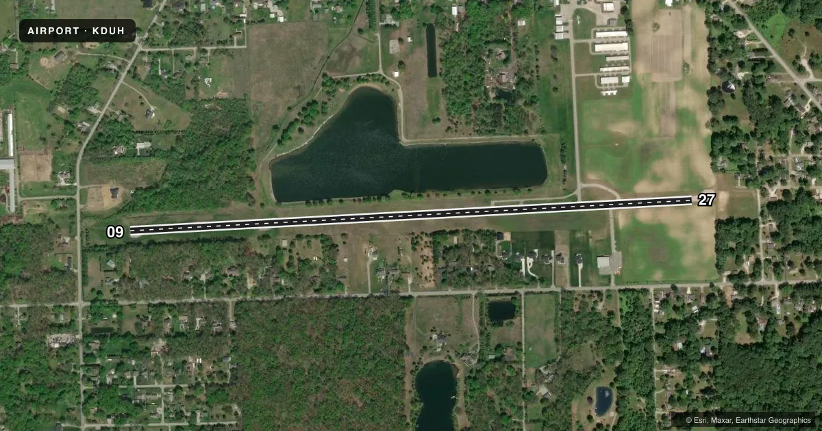
Runways & pattern
Full pagePattern entry · RWY 27
LEFT TRAFFICRunway end performance
| End | TORA | TODA | ASDA | LDA | VGSI | Approach lights | Obstruction |
|---|---|---|---|---|---|---|---|
| 09 | — | — | — | — | — | — | 14', tree, 200' from thr, 98' R of cntrln, slope 0 |
| 27 | — | — | — | — | — | — | 84', tree, 536' from thr, 157' R of cntrln, slope 4 |
Declared distances in feet. TORA = takeoff run available, TODA = takeoff distance, ASDA = accelerate-stop, LDA = landing distance.
Airport sketch
Runways drawn to scale from FAA survey coordinates, rendered over satellite imagery. Not for navigation.
Approaches & charts
Services on the field
Fuel grades, oxygen, maintenance, ramp storage and lighting — as declared to the FAA by the airport operator.
Fuel & services
- Fuel
- 100LL
- Oxygen (bottled)
- Not available
- Oxygen (bulk)
- Not available
- Airframe repair
- Major
- Power plant repair
- Major
- Other services
- INSTR,RNTL
Ramp & ground
- Transient storage
- Tie-down
- Hangar
- Landing fee
- No fee published
- Customs
- Not available
- Lighting schedule
- SEE RMK
- Beacon schedule
- SS-SR
- Beacon
- White / Green (civil land)(WG)
- Wind indicator
- Lighted
- Segmented circle
- Yes
Fuel & FBOs
Cheapest 100LL and Jet A on the field and nearby. Always confirm with the FBO before taxi.
Airport notes
Surface conditions, obstructions, local procedures, lighting outages and other notes published with each FAA cycle.
General notes
- 4 FT FENCE, 110 FT NORTH OF RWY; +8 FT SEASONAL CROPS, 50 FT SOUTH OF RWY IN PRI SFC.
- DEER & LRG BIRDS ON & INVOF ARPT.
- FOR CD CTC TOLEDO APCH AT 419-865-1495.
Lighting notes
- ACTVT NSTD MIRL RWY 09/27 - CTAF.
Runway surface & condition
- 09/27NSTD MIRL DUE TO LCTN 15 FT FM RWY EDGE.
Approach & departure obstructions
- 09FADED.
- 27FADED.
- 09CTLG OBSTN EXCEEDS A 45 DEG SLP. APCH RATIO 20:1 TO DTHR.
- 27APCH RATIO 18:1 TO DTHR OVR +79 FT TREE, 1407 FT DIST, 40 FT L.
Other notes
- ESTABD BFR 1959.
- FOR TSNT HNGR STORAGE CTC AMGR.
VFR map & nearby airports
VFR sectional. Tap any ICAO chip to open that airport.
Key facts · KDUH
Answer card- ICAO
- KDUH
- Name
- TOLEDO SUBURBAN
- Location
- LAMBERTVILLE, MICHIGAN
- Elevation
- 671 ft MSL
- Traffic pattern altitude
- 1,671 ft MSL (1,000 AGL)
- Control tower
- Non-towered (use CTAF)
- Total runways
- 1
- Longest runway
- 09/27 · 4,807 ft
- Published ILS approaches
- 0
- Published frequencies
- 4
- Magnetic variation
- 7°
- Current flight rules
- VFR
- Current wind
- 270° at 7 kt
- Favored runway now
- RWY 27
Toledo Suburban Airport sits in Lambertville, Michigan, near the Toledo area. The field elevation is 671 ft MSL. It has one runway, 09/27, which is 4,807 ft long. There is no control tower. The pattern altitude is not published, so use standard 1,000 ft AGL unless the current Chart Supplement says otherwise.
No ILS approaches are published here. The field uses CTAF 122.7 and UNICOM 122.7. Toledo Approach handles the listed approach and departure frequencies. For clearance delivery, the published remarks direct pilots to Toledo Approach. Suburban Aviation is on the field. It carries 100LL.
The remarks matter here. Runway 09/27 has faded markings. The runway lighting is nonstandard medium intensity lighting because of its location close to the runway edge. The lights are activated via CTAF. There are also trees, a fence, seasonal crops, deer and large birds in the airport area. That makes a careful arrival and departure scan important, especially on short final and in the pattern. Runway 27 has a displaced threshold note tied to an obstruction. Runway 09 has a similar obstruction note. Check the current Chart Supplement before you go. Brief the runway condition and obstacle picture before takeoff.