METAR & TAF KTDZ
Current METAR
Observed 19:53Z
KTDZ 271953Z AUTO 25008KT 10SM CLR 28/21 A2982 RMK AO2 SLP093 T02780211
- Wind
- 250° @ 8 kt
- Visibility
- 10 SM
- Temp / Dew
- 28°C / 21°C
- Altimeter
- 29.82 inHg
- Clouds
- CLR
- Density alt
- 2,456 ft
- Ceiling
- Unlimited
- Rules
- VFR
Airport info & contacts
Manager on record, flight service, ARTCC, attendance schedule and pattern altitude — published by the FAA and refreshed every 28 days.
Location
- From city
- 6 NM SE
- VFR sectional
- DETROIT
- ARTCC
- ZOB · CLEVELAND
- NOTAM facility
- TDZ (NOTAM-D)
Airport manager
- Name
- CHRIS CURRY
- Phone
- 419-243-8251
- Address
- 11013 AIRPORT HWY STE 11, SWANTON OH 43558-9403
Flight service · Hours
- FSS CLE
- CLEVELAND1-800-WX-BRIEF
- Attendance
- MON-SAT · 0800-1800
- SUN · 0800-1700
Frequencies
Tap any row to copy the frequency to your clipboard.
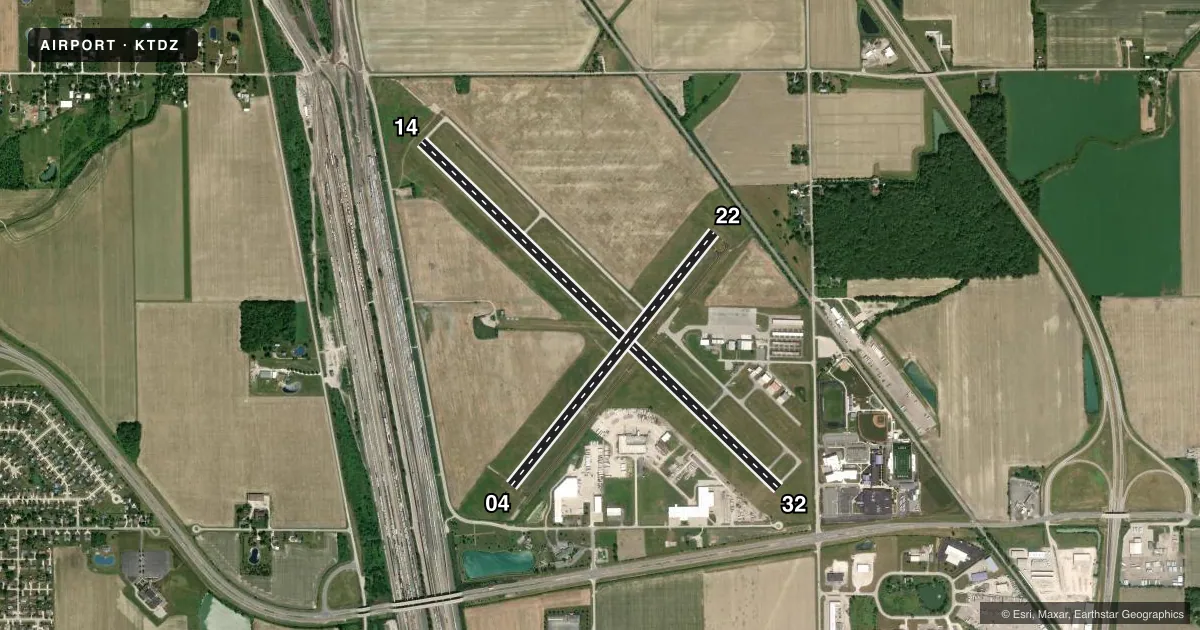
Runways & pattern
Full pagePattern entry · RWY 22
LEFT TRAFFIC| Runway | Heading (°M) | Length | Surface | Traffic |
|---|---|---|---|---|
| 14/32 | 127° / 307° | 5,829 ft | ASPH | Standard L |
| 04/22Favored | 32° / 212° | 3,799 ft | ASPH | Standard L |
Runway end performance
| End | TORA | TODA | ASDA | LDA | VGSI | Approach lights | Obstruction |
|---|---|---|---|---|---|---|---|
| 14 | 5,829' | 5,829' | 5,182' | 4,957' | PAPI 4-box left(3°) | — | 45', tower, 709' from thr, 163' R of cntrln, slope 11 |
| 32 | 5,829' | 5,829' | 5,278' | 4,927' | PAPI 4-box left(3°) | — | 17', road, 352' from thr, 273' R of cntrln, slope 8 |
| 04 | — | — | — | — | PAPI 4-box left(3.5°) | — | 15', road, 412' from thr, 280' R of cntrln, slope 14 |
| 22 | — | — | — | — | PAPI 4-box left(3°) | — | 29', rr, 393' from thr, 144' R of cntrln, slope 6 |
Declared distances in feet. TORA = takeoff run available, TODA = takeoff distance, ASDA = accelerate-stop, LDA = landing distance.
Airport sketch
Runways drawn to scale from FAA survey coordinates, rendered over satellite imagery. Not for navigation.
Approaches & charts
Services on the field
Fuel grades, oxygen, maintenance, ramp storage and lighting — as declared to the FAA by the airport operator.
Fuel & services
- Fuel
- 100LLA
- Oxygen (bottled)
- High pressure
- Oxygen (bulk)
- High pressure
- Airframe repair
- Major
- Power plant repair
- Major
- Other services
- AFRT,CARGO,INSTR,RNTL,SALES
Ramp & ground
- Transient storage
- Tie-down
- Hangar
- Landing fee
- Yes
- Customs
- Not available
- Lighting schedule
- SEE RMK
- Beacon schedule
- SS-SR
- Beacon
- White / Green (civil land)(WG)
- Wind indicator
- Lighted
- Segmented circle
- No
Fuel & FBOs
Cheapest 100LL and Jet A on the field and nearby. Always confirm with the FBO before taxi.
Airport notes
Surface conditions, obstructions, local procedures, lighting outages and other notes published with each FAA cycle.
General notes
- PARL TWY RWY 04/22 & 14/32 35 FT WID.
- DEER & COYOTES ON & INVOF ARPT.
- FOR CD CTC TOLEDO APCH AT 419-865-1495.
Lighting notes
- ACTVT REIL RWY 04, 22, & 14; PAPI RWY 04, 22, 14, & 32; MIRL RWY 04/22 & 14/32 - CTAF.
Fuel notes
- 100LL100LL AVBL SELF SVC OR FULL SVC.
- AJET A AVBL SELF SVC OR FULL SVC.
Approach & departure obstructions
- 04APCH RATIO 20:1 TO DTHR.
- 14APCH RATIO 20:1 TO DTHR.
- 22APCH RATIO 20:1 TO DTHR.
- 32APCH RATIO 17:1 TO DTHR OVR +31 FT TREE, 538 FT DIST, 299 FT L.
Other notes
- ESTABD BFR 1959.
- MANAGERARPT PHYS ADS: 28331 LEMOYNE RD, MILLBURY, OH 43447.
VFR map & nearby airports
VFR sectional. Tap any ICAO chip to open that airport.
Key facts · KTDZ
Answer card- ICAO
- KTDZ
- Name
- TOLEDO EXEC
- Location
- TOLEDO, OHIO
- Elevation
- 622.7 ft MSL
- Traffic pattern altitude
- 1,622.7 ft MSL (1,000 AGL)
- Control tower
- Non-towered (use CTAF)
- Total runways
- 2
- Longest runway
- 14/32 · 5,829 ft
- Published ILS approaches
- 0
- Published frequencies
- 5
- Magnetic variation
- 7°
- Current flight rules
- VFR
- Current wind
- 250° at 8 kt
- Favored runway now
- RWY 22
Toledo Executive Airport sits in Toledo, Ohio. The field elevation is 622.7 ft MSL. It has two asphalt runways. The longest is 5,829 ft on runway 14/32. There is no control tower. CTAF and UNICOM are both 123.05. No ILS approaches are published here.
Pattern altitude is not published. Use the standard 1,000 ft AGL for light piston traffic unless the current FAA Chart Supplement says otherwise. Air America Aviation Services is on the field. It carries 100LL and Jet A. The remarks also note self-serve or full-service fuel for both grades. For clearance delivery, Toledo Approach can be contacted at 419-865-1495.
This is a busy local airport with lighting on both runways. REILs are installed on 04, 22 and 14. PAPI is available on 04, 22, 14 and 32. The airport also has published obstruction notes on the approach to all four runway ends. Runway 32 has a tree hazard near the displaced threshold. Deer and coyotes are reported on and near the airport. Keep a sharp scan on taxi and final. If you need current noise or operating restrictions, check the current FAA Chart Supplement before you go.