METAR & TAF KFZI
KFZI does not publish a METAR.
Showing the nearest reporting station: KFDY (FINDLAY) · 16.5 NM away. Conditions at KFZI may differ.
METAR · KFDY
Observed 11:53Z
KFDY 271153Z AUTO 26004KT 3SM BR CLR 20/20 A2993 RMK AO2 SLP125 T02000200 10206 20183 53015
- Wind
- 260° @ 4 kt
- Visibility
- 3 SM
- Temp / Dew
- 20°C / 20°C
- Altimeter
- 29.93 inHg
- Clouds
- CLR
- Density alt
- 1,520 ft
- Ceiling
- Unlimited
- Rules
- MVFR
Airport info & contacts
Manager on record, flight service, ARTCC, attendance schedule and pattern altitude — published by the FAA and refreshed every 28 days.
Location
- From city
- 2 NM NE
- VFR sectional
- DETROIT
- ARTCC
- ZOB · CLEVELAND
- NOTAM facility
- CLE (NOTAM-D)
Airport manager
- Name
- MATT MCVICKER
- Phone
- 419-435-0157
- Address
- 4495 N COUNTY ROAD 25, FOSTORIA OH 44830-9565
Flight service · Hours
- FSS CLE
- CLEVELAND1-800-WX-BRIEF
- Attendance
- 0800-1700
Frequencies
Tap any row to copy the frequency to your clipboard.
Runways & pattern
Full pagePattern entry · RWY 27
LEFT TRAFFICRunway end performance
| End | TORA | TODA | ASDA | LDA | VGSI | Approach lights | Obstruction |
|---|---|---|---|---|---|---|---|
| 09 | — | — | — | — | PAPI 4-box left(3°) | — | 61', trees, 1541' from thr, 442' R of cntrln, slope 21 |
| 27 | — | — | — | — | PAPI 4-box left(3°) | — | — |
Declared distances in feet. TORA = takeoff run available, TODA = takeoff distance, ASDA = accelerate-stop, LDA = landing distance.
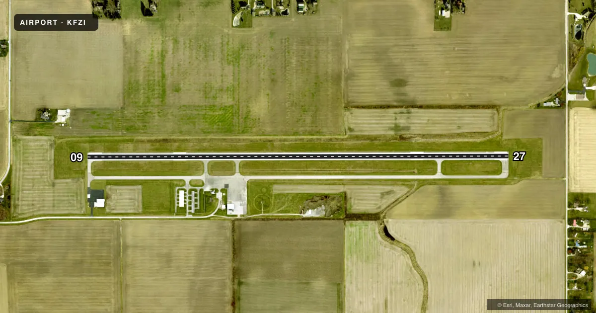
Airport sketch
Runways drawn to scale from FAA survey coordinates, rendered over satellite imagery. Not for navigation.
Approaches & charts
Services on the field
Fuel grades, oxygen, maintenance, ramp storage and lighting — as declared to the FAA by the airport operator.
Fuel & services
- Fuel
- 100LLA
- Oxygen (bottled)
- Not available
- Oxygen (bulk)
- Not available
- Airframe repair
- Not available
- Power plant repair
- Not available
Ramp & ground
- Transient storage
- Tie-down
- Hangar
- Landing fee
- No fee published
- Customs
- Not available
- Lighting schedule
- SEE RMK
- Beacon schedule
- SS-SR
- Beacon
- White / Green (civil land)(WG)
- Wind indicator
- Lighted
- Segmented circle
- No
Fuel & FBOs
Cheapest 100LL and Jet A on the field and nearby. Always confirm with the FBO before taxi.
Airport notes
Surface conditions, obstructions, local procedures, lighting outages and other notes published with each FAA cycle.
General notes
- FOR CD CTC TOLEDO APCH AT 419-865-1495.
Lighting notes
- ACTVT REIL RWY 09 & 27; PAPI RWY 09 & 27; MIRL RWY 09/27 - CTAF.
Other notes
- PRIOR CDN RQRD.
VFR map & nearby airports
VFR sectional. Tap any ICAO chip to open that airport.
Key facts · KFZI
Answer card- ICAO
- KFZI
- Name
- DONALD P MILLER
- Location
- FOSTORIA, OHIO
- Elevation
- 751.6 ft MSL
- Traffic pattern altitude
- 1,751.6 ft MSL (1,000 AGL)
- Control tower
- Non-towered (use CTAF)
- Total runways
- 1
- Longest runway
- 09/27 · 5,005 ft
- Published ILS approaches
- 0
- Published frequencies
- 4
- Magnetic variation
- 5°
- Current flight rules
- MVFR
- Current wind
- 260° at 4 kt
- Favored runway now
- RWY 27
Donald P Miller Airport (KFZI) sits in Fostoria, Ohio. Field elevation is 751.6 ft MSL. The airport has one runway. Runway 09/27 is 5,005 ft of asphalt. There is no control tower. CTAF and UNICOM are both 122.7. Toledo Approach handles approach and departure work on 126.1 and 307.0. For clearance delivery, contact Toledo Approach at 419-865-1495.
No ILS approaches are published here. Pattern altitude is not published, so use the standard 1,000 ft AGL for light piston traffic unless the current Chart Supplement says otherwise. The runway lighting is pilot-controlled on CTAF. Runway 09 and 27 have runway end identifier lights. They also have precision approach path indicators. Prior coordination is required before arrival.
If you are coming in for the first time, plan on a non-towered arrival with normal CTAF self-announce procedures. Check the current Chart Supplement for any noise or curfew restrictions before flying into the field. The published remarks also point to coordination before use, so call ahead if your arrival is anything other than routine. With one 5,005 ft runway and no published ILS, this is a straightforward VFR or GPS-approach field, but you should still brief the lighting setup and the Toledo Approach contact before you launch.