METAR & TAF 5D9
5D9 does not publish a METAR.
Showing the nearest reporting station: KPCW (ERIE-OTTAWA INTL) · 18.0 NM away. Conditions at 5D9 may differ.
METAR · KPCW
Observed 15:15Z
KPCW 271515Z AUTO 26009G15KT 210V290 10SM FEW022 27/22 A2987 RMK AO2
- Wind
- 260° @ 9G15 kt
- Visibility
- 10 SM
- Temp / Dew
- 27°C / 22°C
- Altimeter
- 29.87 inHg
- Clouds
- FEW
- Density alt
- 2,500 ft
- Ceiling
- Unlimited
- Rules
- VFR
Airport info & contacts
Manager on record, flight service, ARTCC, attendance schedule and pattern altitude — published by the FAA and refreshed every 28 days.
Location
- From city
- 5 NM S
- VFR sectional
- DETROIT
- ARTCC
- ZOB · CLEVELAND
- NOTAM facility
- CLE (NOTAM-D)
Airport manager
- Name
- MICHAEL MATESICK
- Phone
- 419-483-3607
- Address
- 6610 TOWNSHIP ROAD 78, GREEN SPRINGS OH 44836
Flight service · Hours
- FSS CLE
- CLEVELAND1-800-WX-BRIEF
- Attendance
- IREG
Frequencies
Tap any row to copy the frequency to your clipboard.
Runways & pattern
Full pagePattern entry · RWY 18
LEFT TRAFFICRunway end performance
| End | TORA | TODA | ASDA | LDA | VGSI | Approach lights | Obstruction |
|---|---|---|---|---|---|---|---|
| 18 | — | — | — | — | — | — | 16', road, 22' from thr, 125' R of cntrln, slope 1 |
Declared distances in feet. TORA = takeoff run available, TODA = takeoff distance, ASDA = accelerate-stop, LDA = landing distance.
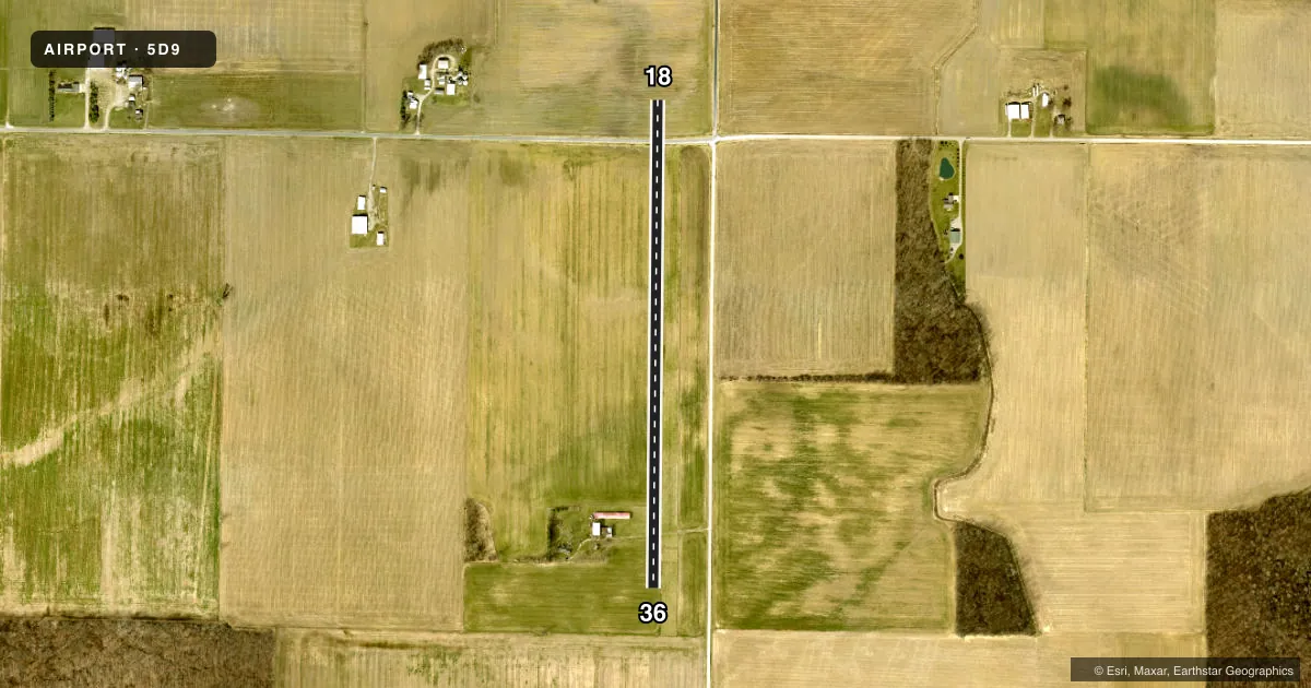
Airport sketch
Runways drawn to scale from FAA survey coordinates, rendered over satellite imagery. Not for navigation.
Approaches & charts
Services on the field
Fuel grades, oxygen, maintenance, ramp storage and lighting — as declared to the FAA by the airport operator.
Fuel & services
- Fuel
- Not available
- Oxygen (bottled)
- Not available
- Oxygen (bulk)
- Not available
- Airframe repair
- Minor
- Power plant repair
- Minor
Ramp & ground
- Transient storage
- Tie-down
- Hangar
- Landing fee
- No fee published
- Wind indicator
- Yes
- Segmented circle
- No
Fuel & FBOs
Cheapest 100LL and Jet A on the field and nearby. Always confirm with the FBO before taxi.
Airport notes
Surface conditions, obstructions, local procedures, lighting outages and other notes published with each FAA cycle.
General notes
- PVT RD CROSSES RWY 18/36 550 FT N OF THE AER RWY 36
- OCCL DEER, BIRDS & OTHER WILDLIFE ON & INVOF ARPT
- FOR CD CTC CLEVELAND APCH AT 216-352-2323, WHEN APCH CLSD CTC CLEVELAND ARTCC AT 440-774-0222.
Approach & departure obstructions
- 18RWY ENDS & DTHR MKD WITH RED/YELLOW CHECKERBOARD PANELS.
- 36RWY ENDS MKD WITH RED/YELLOW CHECKERBOARD PANELS.
Other notes
- PVT RD XING RWY 500'N OF AER 36 CREATING UNSAFE COND FOR ACFT USING RWY.
- TNST HNGR STORAGE ON AVAILABILITY, PRIOR CDN REQUIRED
- TNST TIE-DOWN, PRIOR COORDINATION REQUIRED, USER SUPPLIED ROPES REQUIRED
VFR map & nearby airports
VFR sectional. Tap any ICAO chip to open that airport.
Key facts · 5D9
Answer card- ICAO
- 5D9
- Name
- BANDIT FLD AIRDROME
- Location
- CLYDE, OHIO
- Elevation
- 805 ft MSL
- Traffic pattern altitude
- 1,805 ft MSL (1,000 AGL)
- Control tower
- Non-towered (use CTAF)
- Total runways
- 1
- Longest runway
- 18/36 · 2,630 ft
- Published ILS approaches
- 0
- Published frequencies
- 1
- Magnetic variation
- 5°
- Current flight rules
- VFR
- Current wind
- 260° at 9 kt
- Favored runway now
- RWY 18
BANDIT FLD AIRDROME (5D9) sits near Clyde, Ohio. Field elevation is 805 ft MSL. The airport has one runway. Runway 18/36 is a 2,630 ft turf strip with magnetic headings 181° and 1°. No tower is published, so use CTAF 122.9 for local traffic calls.
No ILS approaches are published here. Pattern altitude is not published in the facts, so use the current FAA Chart Supplement before you fly. The airport has a few operational items that matter on arrival. A private road crosses the runway area north of the aerodrome. The remarks also note red and yellow checkerboard panels at the runway ends. Wildlife is reported on and near the airport, so keep a sharp scan on taxi, takeoff and landing.
There are no on-field FBOs listed. If you need hangar or tie-down help, prior coordination is required. User-supplied ropes are required for transient tie-down. For clearance delivery, contact Cleveland Approach at 216-352-2323. When Approach is closed, contact Cleveland ARTCC at 440-774-0222. First-time pilots should plan for a short turf runway. They should also verify current pattern and local procedures before arrival.