METAR & TAF 16G
16G does not publish a METAR.
Showing the nearest reporting station: KFDY (FINDLAY) · 21.2 NM away. Conditions at 16G may differ.
METAR · KFDY
Observed 17:53Z
KFDY 271753Z AUTO 19011KT 10SM CLR 28/21 A2977 RMK AO2 PRESFR SLP072 60000 T02830206 10283 20200 58039
- Wind
- 190° @ 11 kt
- Visibility
- 10 SM
- Temp / Dew
- 28°C / 21°C
- Altimeter
- 29.77 inHg
- Clouds
- CLR
- Density alt
- 2,721 ft
- Ceiling
- Unlimited
- Rules
- VFR
Airport info & contacts
Manager on record, flight service, ARTCC, attendance schedule and pattern altitude — published by the FAA and refreshed every 28 days.
Location
- From city
- 2 NM SW
- VFR sectional
- DETROIT
- ARTCC
- ZOB · CLEVELAND
- NOTAM facility
- 16G (NOTAM-D)
Airport manager
- Name
- ANDREW NEWMAN
- Phone
- 419-447-1550
- Address
- 1778 W US HIGHWAY 224, TIFFIN OH 44883-8820
Flight service · Hours
- FSS CLE
- CLEVELAND1-800-WX-BRIEF
- Attendance
- MON-FRI · 0800-DUSK
- SAT · 0800-1600
- SUN · 0900-1500
Frequencies
Tap any row to copy the frequency to your clipboard.
Runways & pattern
Full pagePattern entry · RWY 24
LEFT TRAFFICRunway end performance
| End | TORA | TODA | ASDA | LDA | VGSI | Approach lights | Obstruction |
|---|---|---|---|---|---|---|---|
| 06 | — | — | — | — | PAPI 4-box left(3°) | — | — |
| 24 | — | — | — | — | PAPI 4-box left(3°) | — | 70', trees, 612' from thr, 289' R of cntrln, slope 5 |
Declared distances in feet. TORA = takeoff run available, TODA = takeoff distance, ASDA = accelerate-stop, LDA = landing distance.
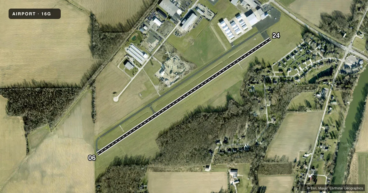
Airport sketch
Runways drawn to scale from FAA survey coordinates, rendered over satellite imagery. Not for navigation.
Approaches & charts
Services on the field
Fuel grades, oxygen, maintenance, ramp storage and lighting — as declared to the FAA by the airport operator.
Fuel & services
- Fuel
- 100LLA+
- Oxygen (bottled)
- High pressure
- Oxygen (bulk)
- HIGH/LOW
- Airframe repair
- Major
- Power plant repair
- Major
- Other services
- INSTR,RNTL,SALES
Ramp & ground
- Transient storage
- Tie-down
- Hangar
- Landing fee
- No fee published
- Customs
- Not available
- Lighting schedule
- SEE RMK
- Beacon schedule
- SS-SR
- Beacon
- White / Green (civil land)(WG)
- Wind indicator
- Lighted
- Segmented circle
- No
Fuel & FBOs
Cheapest 100LL and Jet A on the field and nearby. Always confirm with the FBO before taxi.
Airport notes
Surface conditions, obstructions, local procedures, lighting outages and other notes published with each FAA cycle.
General notes
- FOR CD CTC TOLEDO APCH AT 419-865-1495.
Lighting notes
- ACTVT REIL RWY 06 & 24; PAPI RWY 06 & 24; MIRL RWY 06/24 - CTAF.
Fuel notes
- 100LL100LL & JET A+ AVBL AFT HRS & HOLS SELF SVC VIA CREDIT CARD.
Approach & departure obstructions
- 06PAPI UNUSBL BYD 5 DEGS LEFT OF CNTRLN.
- 24PAPI UNUSBL BYD 4 DEGS LEFT & 8 DEGS RIGHT OF CNTRLN
Other notes
- THIS AIRPORT HAS BEEN SURVEYED BY THE NATIONAL GEODETIC SURVEY.
- 1UNATNDD MAJOR HOLS.
VFR map & nearby airports
VFR sectional. Tap any ICAO chip to open that airport.
Key facts · 16G
Answer card- ICAO
- 16G
- Name
- SENECA COUNTY
- Location
- TIFFIN, OHIO
- Elevation
- 785.9 ft MSL
- Traffic pattern altitude
- 1,785.9 ft MSL (1,000 AGL)
- Control tower
- Non-towered (use CTAF)
- Total runways
- 1
- Longest runway
- 06/24 · 4,000 ft
- Published ILS approaches
- 0
- Published frequencies
- 4
- Magnetic variation
- 5°
- Current flight rules
- VFR
- Current wind
- 190° at 11 kt
- Favored runway now
- RWY 24
Seneca County Airport sits in Tiffin, Ohio. The field elevation is 785.9 ft MSL. It has one runway. Runway 06/24 is 4,000 ft asphalt. The airport is non-towered. CTAF and UNICOM are both 123.0. Toledo Approach handles approach and departure work on 120.8 and 317.55.
No ILS approaches are published here. Pattern altitude is not published in the facts, so use the standard 1,000 ft AGL for light piston traffic unless the current Chart Supplement says otherwise. The airport is unattended on major holidays. Clearance delivery goes through Toledo Approach at 419-865-1495 when needed.
Tiffin Aire is on the field. It carries 100LL and Jet A+ Prist. Self-serve fuel is available after hours and on holidays by credit card. Runway 06 and 24 have REIL, PAPI and MIRL lighting. The PAPI on 06 is unusable beyond 5 degrees left of centerline. The PAPI on 24 is unusable beyond 4 degrees left and 8 degrees right of centerline. This is the kind of detail a first-time arrival should brief before taxi. Check the current Chart Supplement for any local operating notes before you go.