METAR & TAF 44G
44G does not publish a METAR.
Showing the nearest reporting station: KADG (LENAWEE COUNTY) · 9.3 NM away. Conditions at 44G may differ.
METAR · KADG
Observed 18:53Z
KADG 271853Z AUTO VRB06KT 10SM CLR 28/21 A2982 RMK AO2 SLP094 T02780211
- Wind
- VAR @ 6 kt
- Visibility
- 10 SM
- Temp / Dew
- 28°C / 21°C
- Altimeter
- 29.82 inHg
- Clouds
- CLR
- Density alt
- 2,541 ft
- Ceiling
- Unlimited
- Rules
- VFR
Airport info & contacts
Manager on record, flight service, ARTCC, attendance schedule and pattern altitude — published by the FAA and refreshed every 28 days.
Location
- From city
- 1 NM NNW
- VFR sectional
- DETROIT
- ARTCC
- ZOB · CLEVELAND
- NOTAM facility
- LAN (NOTAM-D)
Airport manager
- Name
- DIANE SPILLMAN
- Phone
- 517-499-4860
- Address
- PO BOX 115, BLISSFIELD MI 49228-0115
Flight service · Hours
- FSS LAN
- LANSING1-800-WX-BRIEF
- Attendance
- Unattended
Frequencies
Tap any row to copy the frequency to your clipboard.
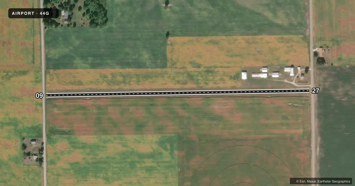
Runways & pattern
Full pagePattern entry · RWY 09
LEFT TRAFFICRunway end performance
| End | TORA | TODA | ASDA | LDA | VGSI | Approach lights | Obstruction |
|---|---|---|---|---|---|---|---|
| 09 | — | — | — | — | — | — | 15', road, 30' from thr, 128' R of cntrln, slope 2 |
| 27 | — | — | — | — | — | — | 17', road, 45' from thr, 129' R of cntrln, slope 2 |
Declared distances in feet. TORA = takeoff run available, TODA = takeoff distance, ASDA = accelerate-stop, LDA = landing distance.
Airport sketch
Runways drawn to scale from FAA survey coordinates, rendered over satellite imagery. Not for navigation.
Approaches & charts
Services on the field
Fuel grades, oxygen, maintenance, ramp storage and lighting — as declared to the FAA by the airport operator.
Fuel & services
- Fuel
- Not available
- Oxygen (bottled)
- Not available
- Oxygen (bulk)
- Not available
- Airframe repair
- Not available
- Power plant repair
- Not available
Ramp & ground
- Transient storage
- Tie-down
- Landing fee
- No fee published
- Customs
- Not available
- Wind indicator
- Yes
- Segmented circle
- No
Fuel & FBOs
Cheapest 100LL and Jet A on the field and nearby. Always confirm with the FBO before taxi.
Airport notes
Surface conditions, obstructions, local procedures, lighting outages and other notes published with each FAA cycle.
General notes
- RWY 09: -3 FT DITCH, 10 FT FM THR.
- FOR CD CTC DETROIT APCH AT 734-955-1404.
- RWY 09/27: +8 FT SEASONAL CROPS IN PRI SFC MAY RSTR VIS TO RWY CONES.
- DEER & LRG BIRDS ON & INVOF ARPT.
Runway surface & condition
- 09/27CLSD WHEN SNOW COVD EXC FOR SKI EQUIPPED ACFT.
Approach & departure obstructions
- 09RWY & DTHR MKD WITH 2 FT YELLOW CONES.
- 27RWY & DTHR MKD WITH 2 FT YELLOW CONES.
- 09APCH RATIO 20:1 TO DTHR.
- 27APCH RATIO 11:1 TO DTHR OVR +26 FT BLDG, 300 FT DIST, 155 FT R.
- 2720 FT MKD PLINE, 375 FT FM THR.
Other notes
- ESTABD BFR 1959.
- 09/27SOFT IN SPRING.
VFR map & nearby airports
VFR sectional. Tap any ICAO chip to open that airport.
Key facts · 44G
Answer card- ICAO
- 44G
- Name
- BETZ
- Location
- BLISSFIELD, MICHIGAN
- Elevation
- 691 ft MSL
- Traffic pattern altitude
- 1,691 ft MSL (1,000 AGL)
- Control tower
- Non-towered (use CTAF)
- Total runways
- 1
- Longest runway
- 09/27 · 2,602 ft
- Published ILS approaches
- 0
- Published frequencies
- 1
- Magnetic variation
- 5°
- Current flight rules
- VFR
- Current wind
- 000° at 6 kt
- Favored runway now
- RWY 09
BETZ Airport (44G) is in Blissfield, Michigan. The field elevation is 691 ft MSL. It has one runway, 09/27, which is 2,602 ft of turf. There is no control tower. CTAF is 122.9. No ILS approaches are published here. Pattern altitude is not published, so use the standard 1,000 ft AGL for light piston aircraft unless the current Chart Supplement says otherwise.
Betz Airport has one on-field FBO listed as Betz Airport. Fuel grades are not reported in the facts, so call the field directly at (517) 499-4860 before you go. The airport sits in open country near the Michigan-Ohio border. Expect local traffic to be working a non-towered pattern. Clearance delivery for IFR release or other clearance needs is handled through Detroit Approach at 734-955-1404.
There are a few runway details worth planning for. Runway 09/27 is marked with yellow cones at the runway and displaced threshold. Runway 09 has a ditch 3 ft below field elevation near the threshold. Runway 27 has a 26 ft building near the threshold plus a marked 20 ft power line farther out. The runway surface is soft in spring. It is also closed when snow covered except for ski-equipped aircraft. Deer, large birds and seasonal crops in the primary surface are part of the picture here. Keep the scan tight on short final and during rollout.