METAR & TAF 22T
22T does not publish a METAR.
Showing the nearest reporting station: KARB (ANN ARBOR MUNI) · 12.8 NM away. Conditions at 22T may differ.
METAR · KARB
Observed 14:53Z
KARB 271453Z RMK AO2 SLPNO $
- Wind
- Calm
- Visibility
- —
- Temp / Dew
- —
- Altimeter
- —
- Clouds
- Clear
- Density alt
- —
- Ceiling
- Unlimited
- Rules
- VFR
Airport info & contacts
Manager on record, flight service, ARTCC, attendance schedule and pattern altitude — published by the FAA and refreshed every 28 days.
Location
- From city
- 4 NM NE
- VFR sectional
- DETROIT
- ARTCC
- ZOB · CLEVELAND
- NOTAM facility
- LAN (NOTAM-D)
Airport manager
- Name
- DANIEL MILLS
- Phone
- 734-476-1517
- Address
- 9398 NEAL RD, MANCHESTER MI 48158-9539
Flight service · Hours
- FSS LAN
- LANSING1-800-WX-BRIEF
- Attendance
- Unattended
Frequencies
Tap any row to copy the frequency to your clipboard.
Runways & pattern
Full pagePattern entry · RWY 13
LEFT TRAFFIC| Runway | Heading (°M) | Length | Surface | Traffic |
|---|---|---|---|---|
| 13/31 | 125° / 305° | 4,278 ft | ASPH | Standard L |
| 07/25 | 63° / 243° | 4,258 ft | ASPH | Standard L |
Runway end performance
| End | TORA | TODA | ASDA | LDA | VGSI | Approach lights | Obstruction |
|---|---|---|---|---|---|---|---|
| 13 | — | — | — | — | — | — | 95', trees, 1549' from thr, 0' R of cntrln, slope 14 |
| 31 | — | — | — | — | — | — | 22', road, 200' from thr, 116' R of cntrln, slope 1 |
| 07 | — | — | — | — | — | — | 17', road, 266' from thr, 131' R of cntrln, slope 3 |
Declared distances in feet. TORA = takeoff run available, TODA = takeoff distance, ASDA = accelerate-stop, LDA = landing distance.
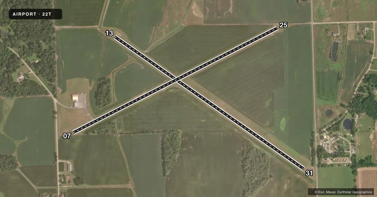
Airport sketch
Runways drawn to scale from FAA survey coordinates, rendered over satellite imagery. Not for navigation.
Approaches & charts
Services on the field
Fuel grades, oxygen, maintenance, ramp storage and lighting — as declared to the FAA by the airport operator.
Fuel & services
- Fuel
- Not available
- Oxygen (bottled)
- Not available
- Oxygen (bulk)
- Not available
- Airframe repair
- Not available
- Power plant repair
- Not available
Ramp & ground
- Transient storage
- Tie-down
- Wind indicator
- Yes
- Segmented circle
- No
Fuel & FBOs
Cheapest 100LL and Jet A on the field and nearby. Always confirm with the FBO before taxi.
Airport notes
Surface conditions, obstructions, local procedures, lighting outages and other notes published with each FAA cycle.
General notes
- FOR CD CTC DETROIT APCH AT 734-955-1404.
- DEER & LRG BIRDS ON & INVOF ARPT.
- CALL AMGR TO VFY FLD CONDS IN WINTER MONTHS.
Approach & departure obstructions
- 07+10 FT SEASONAL CROPS, 0 FT DIST, 125 FT L/R.
- 25+10 FT PVT ROAD, 0 FT DIST, 95 FT R; +6 FT SEASONAL CROPS.
- 31+3 FT FENCE ATOP +9 FT ELEVD TRRN, 145-200 FT DIST, 40-125 FT R.
- 07APCH RATIO 20:1 TO DTHR OVR +83 FT TREE, 1693 FT DIST, 20 FT L.
- 13APCH RATIO 19:1 TO DTHR OVR +99 FT TREE, 1950 FT DIST, 0 FT B.
- 25+27 FT UNMKD PLINE, 650-800 FT DIST; +55 FT MKD PLINE, 1500-1800 FT DIST.
Other notes
- PRVDD ANY OBSTNS REMOVED/LWRD OR THR DSPLCD & CLEARLY MKD TO PRVD A MNM 20:1 APCH SLP SFC CLNC OVR ANY OBSTNS IN THE RWY APCH; THE RWY OFZ IS TO BE FREE OF OBSTNS IN THAT AREA 125 FT EITHER SIDE OF THE RWY CNTRLN & EXTDG 200 FT OFF THE RWY ENDS; THE RWY SAFETY AREA IS TO BE FREE OF OBJECTS & POTENTIALLY HAZUS RUTS, HUMPS, DEPRESSIONS, ETC IN THAT AREA 60 FT EITHER SIDE OF THE RWY CNTRLN & EXTDG 240 FT OFF THE RWY ENDS.
VFR map & nearby airports
VFR sectional. Tap any ICAO chip to open that airport.
Key facts · 22T
Answer card- ICAO
- 22T
- Name
- TECUMSEH MILLS
- Location
- TECUMSEH, MICHIGAN
- Elevation
- 797 ft MSL
- Traffic pattern altitude
- 1,797 ft MSL (1,000 AGL)
- Control tower
- Non-towered (use CTAF)
- Total runways
- 2
- Longest runway
- 13/31 · 4,278 ft
- Published ILS approaches
- 0
- Published frequencies
- 1
- Magnetic variation
- –
- Current flight rules
- VFR
- Current wind
- Calm / unavailable
- Favored runway now
- –
Tecumseh Mills Airport sits in Tecumseh, Michigan. Field elevation is 797 ft MSL. The airport has two asphalt runways. The longest is 4,278 ft on 13/31. Runway 07/25 is 4,258 ft. There is no control tower, so plan on CTAF self-announce work on 122.9. No ILS approaches are published here.
Pattern altitude is not published. Use 1,000 ft AGL as the standard light piston pattern unless local conditions or current guidance say otherwise. That puts the pattern at 1,797 ft MSL based on the field elevation. There are no on-field FBOs listed, so verify services with the airport operator before you go. If you need clearance delivery, Detroit Approach is listed at 734-955-1404.
The published remarks matter here. There are power lines near the runway 25 end. There is also a private road close to that end. Runway 31 has a fence and elevated terrain near the departure end. Runway 13 has a tree on the approach path. Deer and large birds are reported on and near the airport. Winter field conditions should be confirmed with the airport manager before arrival. For a first trip, treat this as a non-towered field with real obstacle awareness on both ends. Check the current FAA Chart Supplement for any updated local procedures or restrictions before you fly in.