METAR & TAF KJXN
Current METAR
Observed 15:56Z
KJXN 271556Z 23011G21KT 10SM FEW010 26/21 A2984 RMK AO2 PRESFR SLP097 T02560206
- Wind
- 230° @ 11G21 kt
- Visibility
- 10 SM
- Temp / Dew
- 26°C / 21°C
- Altimeter
- 29.84 inHg
- Clouds
- FEW
- Density alt
- 2,660 ft
- Ceiling
- Unlimited
- Rules
- VFR
Airport info & contacts
Manager on record, flight service, ARTCC, attendance schedule and pattern altitude — published by the FAA and refreshed every 28 days.
Location
- From city
- 2 NM W
- VFR sectional
- DETROIT
- ARTCC
- ZOB · CLEVELAND
- NOTAM facility
- JXN (NOTAM-D)
Airport manager
- Name
- JUAN ZAPATA
- Phone
- 517-788-4225
- Address
- 3606 WILDWOOD AVE, JACKSON MI 49202-1864
Flight service · Hours
- FSS LAN
- LANSING1-800-WX-BRIEF
- Attendance
- MON-FRI · 0800-1700
- SAT-SUN · 0800-1500
Frequencies
Tap any row to copy the frequency to your clipboard.
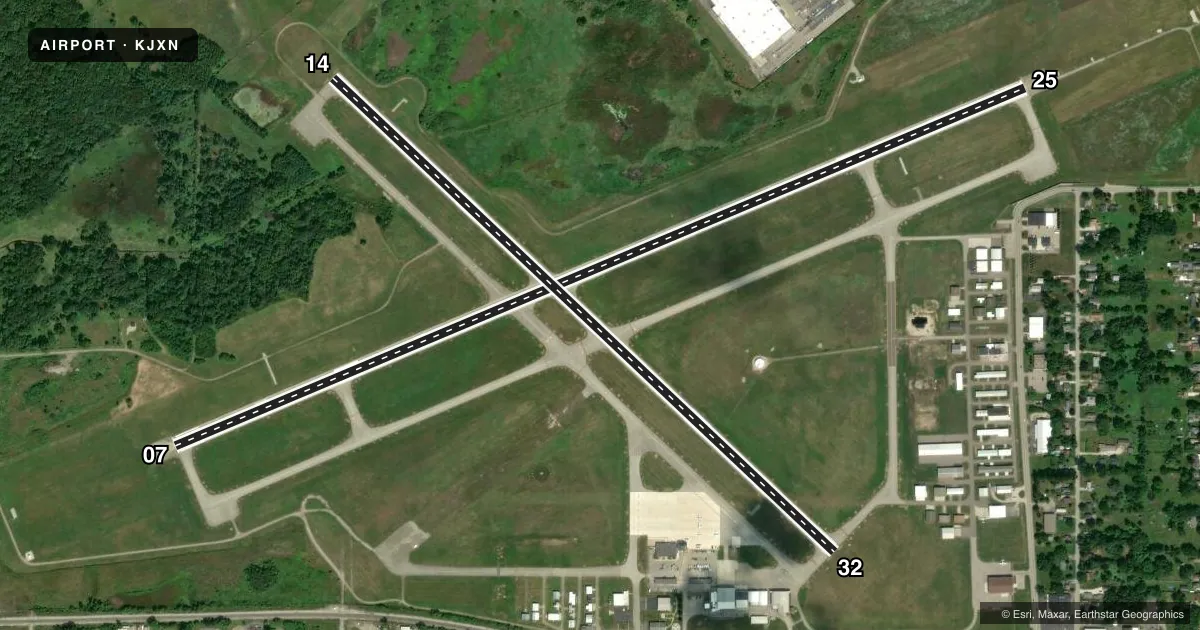
Runways & pattern
Full pagePattern entry · RWY 25
LEFT TRAFFIC| Runway | Heading (°M) | Length | Surface | Traffic |
|---|---|---|---|---|
| 07/25Favored | 60° / 240° | 5,351 ft | ASPH | Standard L |
| 14/32 | 126° / 306° | 4,000 ft | ASPH | Standard L |
Runway end performance
| End | TORA | TODA | ASDA | LDA | VGSI | Approach lights | Obstruction |
|---|---|---|---|---|---|---|---|
| 07 | — | — | — | — | PAPI 4-box left(3°) | — | 72', pline, 1613' from thr, 660' R of cntrln, slope 19 |
| 25 | — | — | — | — | PAPI 4-box left(3°) | MALSR | 94', trees, 2758' from thr, 773' R of cntrln, slope 27 |
| 14 | — | — | — | — | PAPI 4-box left(3°) | — | 20', tree, 438' from thr, 125' R of cntrln, slope 11 |
| 32 | — | — | — | — | PAPI 4-box left(3.5°) | — | 89', tree, 1924' from thr, 100' R of cntrln, slope 19 |
Declared distances in feet. TORA = takeoff run available, TODA = takeoff distance, ASDA = accelerate-stop, LDA = landing distance.
Airport sketch
Runways drawn to scale from FAA survey coordinates, rendered over satellite imagery. Not for navigation.
Approaches & charts
ILS · 1
Services on the field
Fuel grades, oxygen, maintenance, ramp storage and lighting — as declared to the FAA by the airport operator.
Fuel & services
- Fuel
- 100LLA+
- Oxygen (bottled)
- Not available
- Oxygen (bulk)
- Not available
- Airframe repair
- Major
- Power plant repair
- Major
- Other services
- INSTR
Ramp & ground
- Transient storage
- Tie-down
- Hangar
- Landing fee
- No fee published
- Customs
- Not available
- Lighting schedule
- SEE RMK
- Beacon schedule
- SS-SR
- Beacon
- White / Green (civil land)(WG)
- Wind indicator
- Lighted
- Segmented circle
- Yes
Fuel & FBOs
Cheapest 100LL and Jet A on the field and nearby. Always confirm with the FBO before taxi.
Airport notes
Surface conditions, obstructions, local procedures, lighting outages and other notes published with each FAA cycle.
General notes
- DEER & LRG BIRDS ON & INVOF ARPT.
- LOW ALT HEL OPS PROHIBITED INVOF PRISON 4 MI NE.
- WINTER FICONS UNMON WHEN ATCT CLSD.
- ACFT TAXIING UP TWY D COULD POSSLY MISS THE TURN FOR TWY A & VIOLATE THE SAFETY ZONE FOR RWY 07/25.
- FOR CD WHEN ATCT CLSD CTC GREAT LAKES APCH AT 269-459-3345, WHEN APCH CLSD CTC CLEVELAND ARTCC AT 440-774-0224/0490.
Lighting notes
- WHEN ATCT CLSD ACTVT MALSR RWY 25; REIL RWY 07 & 32; PAPI RWY 07, 25, 14 & 32; HIRL RWY 07/25; MIRL RWY 14/32 - CTAF.
Fuel notes
- 100LL100LL & JET A+ AVBL SELF SVC ON MAIN RAMP.
Other notes
- PRVDD SFC APROPLY MKD; IF USED AT NGT RWY APROPLY LGTD INCLG EDGE LGTS; CLEAR FAR PART 77 20:1 APCH SFCS TO BOTH RWY ENDS; 300 FT & ASSOCD EDGE RWY SAFETY AREAS PRVDD; HOLD SHORT LINES PAINTED ON ALL ADJ TWYS; AREA BYD EACH THR MKD AS TWYS NOT DSPLCD THRS; THR COORDS & ELEVS PRVDD TO AGL-200.
VFR map & nearby airports
VFR sectional. Tap any ICAO chip to open that airport.
Key facts · KJXN
Answer card- ICAO
- KJXN
- Name
- JACKSON COUNTY/REYNOLDS FLD
- Location
- JACKSON, MICHIGAN
- Elevation
- 1,000.8 ft MSL
- Traffic pattern altitude
- 2,000.8 ft MSL (1,000 AGL)
- Control tower
- Towered · 0700-2100
- Total runways
- 2
- Longest runway
- 07/25 · 5,351 ft
- Published ILS approaches
- 1
- Published frequencies
- 11
- Magnetic variation
- 7°
- Current flight rules
- VFR
- Current wind
- 230° at 11 kt
- Favored runway now
- RWY 25
Jackson County/Reynolds Fld sits in Jackson, Michigan. Field elevation is 1,000.8 ft MSL. The airport has two asphalt runways. The longest is runway 07/25 at 5,351 ft. The tower is open from 0700 to 2100. One ILS is published for runway 25.
Pattern altitude is not published. Use 1,000 ft AGL as the standard light-piston pattern unless local instructions say otherwise. Skyway Aviation is on the field. It carries 100LL and Jet A. Self-serve fuel is available on the main ramp.
The field has a few things a first-time pilot should plan for. Deer and large birds are reported on and near the airport. Taxiway D can lead crews past the turn for taxiway A. That can put an aircraft near the runway 07/25 safety zone. Low altitude helicopter operations are prohibited near the prison 4 miles northeast. When the tower is closed, lighting is activated on CTAF. Check the current FAA Chart Supplement for any noise or curfew restrictions before flying in. This is a controlled field with published approach support from Great Lakes. Tower hours matter here, so plan your arrival with the current operating status in mind.