METAR & TAF KOEB
Current METAR
Observed 13:36Z
KOEB 271336Z AUTO 22010KT 4SM -DZ BR SCT070 BKN090 OVC110 23/22 A2989 RMK AO2 PRESFR
- Wind
- 220° @ 10 kt
- Visibility
- 4 SM
- Temp / Dew
- 23°C / 22°C
- Altimeter
- 29.89 inHg
- Clouds
- OVC
- Density alt
- 2,185 ft
- Ceiling
- 9,000 ft AGL
- Rules
- MVFR
Airport info & contacts
Manager on record, flight service, ARTCC, attendance schedule and pattern altitude — published by the FAA and refreshed every 28 days.
Location
- From city
- 3 NM W
- VFR sectional
- CHICAGO
- ARTCC
- ZAU · CHICAGO
- NOTAM facility
- OEB (NOTAM-D)
Airport manager
- Name
- JOSEPH J BEST
- Phone
- 269-419-9904
- Address
- 351 AIRPORT DR, COLDWATER MI 49036-9313
Flight service · Hours
- FSS LAN
- LANSING1-800-WX-BRIEF
- Attendance
- MON-FRI · 0900-1700
Frequencies
Tap any row to copy the frequency to your clipboard.
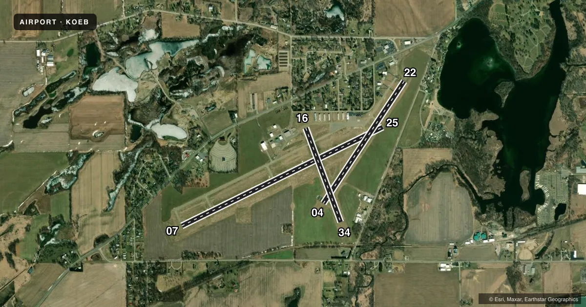
Runways & pattern
Full pagePattern entry · RWY 22
LEFT TRAFFIC| Runway | Heading (°M) | Length | Surface | Traffic |
|---|---|---|---|---|
| 07/25 | 59° / 239° | 5,350 ft | ASPH | Standard L |
| 04/22Favored | 29° / 209° | 3,500 ft | ASPH | Standard L |
| 16/34 | 155° / 335° | 2,399 ft | TURF | Standard L |
Runway end performance
| End | TORA | TODA | ASDA | LDA | VGSI | Approach lights | Obstruction |
|---|---|---|---|---|---|---|---|
| 07 | — | — | — | — | PAPI 2-box left(3°) | — | 40', tree, 1003' from thr, 316' R of cntrln, slope 20 |
| 25 | — | — | — | — | PAPI 2-box left(3°) | — | 15', road, 383' from thr, 268' R of cntrln, slope 12 |
| 16 | — | — | — | — | — | — | 65', trees, 462' from thr, 143' R of cntrln, slope 7 |
| 34 | — | — | — | — | — | — | 71', trees, 1133' from thr, 228' R of cntrln, slope 15 |
Declared distances in feet. TORA = takeoff run available, TODA = takeoff distance, ASDA = accelerate-stop, LDA = landing distance.
Airport sketch
Runways drawn to scale from FAA survey coordinates, rendered over satellite imagery. Not for navigation.
Approaches & charts
Services on the field
Fuel grades, oxygen, maintenance, ramp storage and lighting — as declared to the FAA by the airport operator.
Fuel & services
- Fuel
- 100LLA+
- Oxygen (bottled)
- Not available
- Oxygen (bulk)
- Not available
- Airframe repair
- Major
- Power plant repair
- Major
- Other services
- INSTR,RNTL,SALES
Ramp & ground
- Transient storage
- Tie-down
- Hangar
- Landing fee
- No fee published
- Customs
- Not available
- Lighting schedule
- SEE RMK
- Beacon schedule
- SS-SR
- Beacon
- White / Green (civil land)(WG)
- Wind indicator
- Lighted
- Segmented circle
- Yes
Fuel & FBOs
Cheapest 100LL and Jet A on the field and nearby. Always confirm with the FBO before taxi.
Airport notes
Surface conditions, obstructions, local procedures, lighting outages and other notes published with each FAA cycle.
General notes
- RWY 16/34 NOT PLOWED, CLSD NOV-MAR.
- BIRDS & DEER ON & INVOF ARPT.
- ADMIN BLDG ACES: 1-2-2-7 (CTAF).
- FOR CD CTC GREAT LAKES APCH AT 269-459-3344, WHEN APCH CLSD CTC CHICAGO ARTCC AT 630-906-8921.
Lighting notes
- ACTVT REIL RWY 07 & 25; PAPI RWY 07 & 25; MIRL RWY 07/25 & 04/22 - CTAF.
Fuel notes
- 100LLFUEL AVBL H24 SELF SVC; FOR ATTENDANT AFT HRS & WKENDS CALL 517-677-1888.
Approach & departure obstructions
- 25CALM WIND RWY.
- 16RWY & DTHR MKD WITH 3 FT YELLOW CONES.
- 34RWY & DTHR MKD WITH 3 FT YELLOW CONES.
- 16APCH RATIO 16:1 TO DTHR OVR 65 FT TREES, 1056 FT DIST, 143 FT L.
- 34APCH RATIO 15:1 TO DTHR OVR 52 FT TREES, 780 FT DIST, 135 FT R.
Other notes
- MANAGERAVBL AFT HRS & WKENDS.
VFR map & nearby airports
VFR sectional. Tap any ICAO chip to open that airport.
Key facts · KOEB
Answer card- ICAO
- KOEB
- Name
- BRANCH COUNTY MEML
- Location
- COLDWATER, MICHIGAN
- Elevation
- 958.3 ft MSL
- Traffic pattern altitude
- 1,958.3 ft MSL (1,000 AGL)
- Control tower
- Non-towered (use CTAF)
- Total runways
- 3
- Longest runway
- 07/25 · 5,350 ft
- Published ILS approaches
- 0
- Published frequencies
- 4
- Magnetic variation
- 5°
- Current flight rules
- MVFR
- Current wind
- 220° at 10 kt
- Favored runway now
- RWY 22
Branch County Meml Airport (KOEB) sits in Coldwater, Michigan. Field elevation is 958.3 ft MSL. The airport has 3 runways. The longest is runway 07/25 at 5,350 ft. There is no control tower. Traffic pattern altitude is not published, so light piston pilots should plan on the standard 1,000 ft AGL unless the current Chart Supplement says otherwise.
No ILS approaches are published here. Runway 07 and runway 25 have runway end identifier lights. Precision approach path indicators are installed on 07 and 25. Medium intensity runway lights are installed on 07/25 and 04/22. They are controlled by the CTAF. Runway 25 is listed as the calm wind runway. Runway 16/34 is not plowed and is closed from November through March. That matters in winter. Runway 34 and its displaced threshold are marked with 3-foot yellow cones. Runway 16 has the same cone marking. Trees are noted near the approach paths for 16 and 34, so brief the displaced thresholds before you arrive.
Elite Air Service is on the field. It carries 100LL and Jet A Prist. 100LL is available 24 hours a day by self-serve. Airport management is available after hours and on weekends. Birds and deer are present on and near the airport. Keep a sharp scan on taxi, takeoff and final.