METAR & TAF KIRS
Current METAR
Observed 13:35Z
KIRS 271335Z AUTO 23004KT 1 3/4SM -RA BR OVC004 23/22 A2991 RMK AO2 PRESFR
- Wind
- 230° @ 4 kt
- Visibility
- 0.75 SM
- Temp / Dew
- 23°C / 22°C
- Altimeter
- 29.91 inHg
- Clouds
- OVC
- Density alt
- 2,119 ft
- Ceiling
- 400 ft AGL
- Rules
- LIFR
Airport info & contacts
Manager on record, flight service, ARTCC, attendance schedule and pattern altitude — published by the FAA and refreshed every 28 days.
Location
- From city
- 1 NM NW
- VFR sectional
- CHICAGO
- ARTCC
- ZAU · CHICAGO
- NOTAM facility
- IRS (NOTAM-D)
Airport manager
- Name
- THOMAS SIKORSKI
- Phone
- 269-659-7286
- Address
- 130 N NOTTAWA ST, PO BOX 280, STURGIS MI 49091-1197
Flight service · Hours
- FSS LAN
- LANSING1-800-WX-BRIEF
- Attendance
- MON-FRI · 0800-1700
Frequencies
Tap any row to copy the frequency to your clipboard.
Runways & pattern
Full pagePattern entry · RWY 24
LEFT TRAFFIC| Runway | Heading (°M) | Length | Surface | Traffic |
|---|---|---|---|---|
| 01/19 | 354° / 174° | 5,201 ft | ASPH | Standard L |
| 06/24Favored | 53° / 233° | 3,601 ft | ASPH | Standard L |
Runway end performance
| End | TORA | TODA | ASDA | LDA | VGSI | Approach lights | Obstruction |
|---|---|---|---|---|---|---|---|
| 01 | — | — | — | — | PAPI 4-box left(3°) | — | 56', trees, 1600' from thr, 125' R of cntrln, slope 25 |
| 19 | — | — | — | — | PAPI 4-box left(3°) | — | — |
| 24 | — | — | — | — | PAPI 2-box left(4°) | — | 59', trees, 831' from thr, 305' R of cntrln, slope 10 |
Declared distances in feet. TORA = takeoff run available, TODA = takeoff distance, ASDA = accelerate-stop, LDA = landing distance.
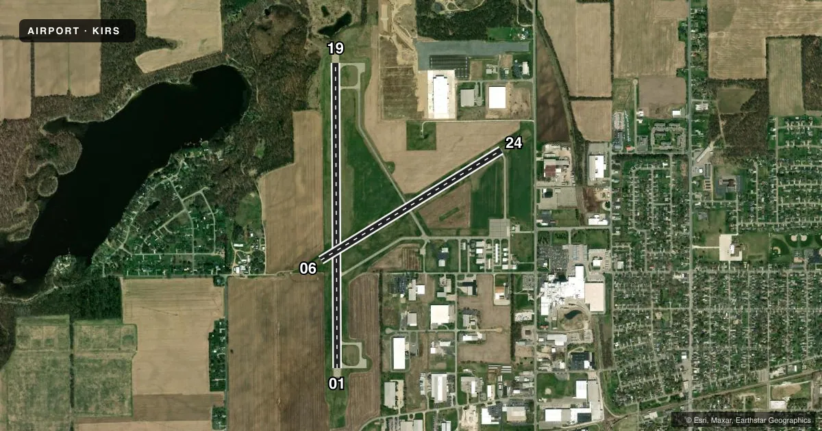
Airport sketch
Runways drawn to scale from FAA survey coordinates, rendered over satellite imagery. Not for navigation.
Approaches & charts
Services on the field
Fuel grades, oxygen, maintenance, ramp storage and lighting — as declared to the FAA by the airport operator.
Fuel & services
- Fuel
- 100LLA+
- Oxygen (bottled)
- Low pressure
- Airframe repair
- Major
- Power plant repair
- Major
- Other services
- CHTR,SALES
Ramp & ground
- Transient storage
- Tie-down
- Hangar
- Landing fee
- No fee published
- Customs
- Not available
- Lighting schedule
- SEE RMK
- Beacon schedule
- SS-SR
- Beacon
- White / Green (civil land)(WG)
- Wind indicator
- Lighted
- Segmented circle
- No
Fuel & FBOs
Cheapest 100LL and Jet A on the field and nearby. Always confirm with the FBO before taxi.
Airport notes
Surface conditions, obstructions, local procedures, lighting outages and other notes published with each FAA cycle.
General notes
- FOR CD CTC GREAT LAKES APCH AT 269-459-3344, WHEN APCH CLSD CTC CHICAGO ARTCC AT 630-906-8921.
- CALL AWOS FOR SNOW REMOVAL INFO & RWY COND RPRT.
- DEER, BIRDS, & WILDLIFE ON & INVOF ARPT.
Lighting notes
- ACTVT REIL RWY 24, 01, & 19; PAPI RWY 24, 01, & 19; MIRL RWY 06/24 & 01/19 - CTAF.
Other notes
- MANAGERFBO.
VFR map & nearby airports
VFR sectional. Tap any ICAO chip to open that airport.
Key facts · KIRS
Answer card- ICAO
- KIRS
- Name
- KIRSCH MUNI
- Location
- STURGIS, MICHIGAN
- Elevation
- 924.8 ft MSL
- Traffic pattern altitude
- 1,924.8 ft MSL (1,000 AGL)
- Control tower
- Non-towered (use CTAF)
- Total runways
- 2
- Longest runway
- 01/19 · 5,201 ft
- Published ILS approaches
- 0
- Published frequencies
- 4
- Magnetic variation
- 6°
- Current flight rules
- LIFR
- Current wind
- 230° at 4 kt
- Favored runway now
- RWY 24
Kirsch Muni is in Sturgis, Michigan. Field elevation is 924.8 ft MSL. The airport has two asphalt runways. The longest is 5,201 ft on runway 01/19. There is no control tower. CTAF and UNICOM are both 123.05. Great Lakes Approach handles clearance delivery. Published approach frequencies are 121.2 and 239.25. No ILS approaches are published here.
The published pattern altitude is not listed, so use the standard 1,000 ft AGL for light piston operations unless current local guidance says otherwise. That puts the traffic pattern at about 1,925 ft MSL based on the field elevation. Kirsch Municipal Airport is the on-field FBO. It carries AVGAS 100LL. Call ahead at (269) 651-2821 if you need current fuel or ramp details.
A few operational notes matter here. Runway 24 markings are faded. Runway 06 markings are faded too. Runway end identifier lights, PAPI and medium intensity runway lights are published on both runways, so night ops are supported. The Chart Supplement also notes deer and birds on and near the runways. Call for snow removal information and a runway condition report before winter arrivals. If approach is closed, contact Chicago ARTCC for clearance delivery.