METAR & TAF KHAI
Current METAR
Observed 12:35Z
KHAI 261235Z AUTO 22003KT 10SM SCT010 21/20 A2995 RMK AO2
- Wind
- 220° @ 3 kt
- Visibility
- 10 SM
- Temp / Dew
- 21°C / 20°C
- Altimeter
- 29.95 inHg
- Clouds
- SCT
- Density alt
- 1,703 ft
- Ceiling
- Unlimited
- Rules
- VFR
Airport info & contacts
Manager on record, flight service, ARTCC, attendance schedule and pattern altitude — published by the FAA and refreshed every 28 days.
Location
- From city
- 2 NM NE
- VFR sectional
- CHICAGO
- Pattern altitude
- 1,000 ft AGL · 1,823 ft MSL
- ARTCC
- ZAU · CHICAGO
- NOTAM facility
- HAI (NOTAM-D)
Airport manager
- Name
- DAN MILLER
- Phone
- 269-273-1845
- Address
- 333 W MICHIGAN AVE, THREE RIVERS MI 49093-2193
Flight service · Hours
- FSS LAN
- LANSING1-800-WX-BRIEF
- Attendance
- Unattended
Frequencies
Tap any row to copy the frequency to your clipboard.
Runways & pattern
Full pagePattern entry · RWY 23
LEFT TRAFFIC| Runway | Heading (°M) | Length | Surface | Traffic |
|---|---|---|---|---|
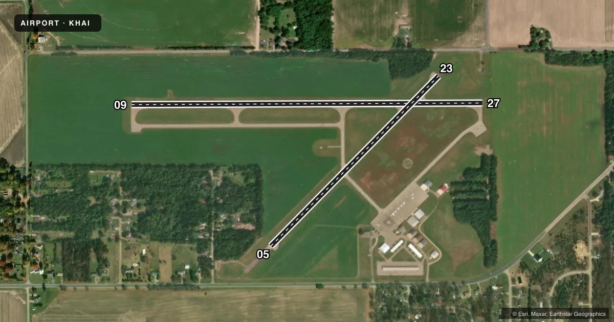
| 09/27 | 86° / 266° | 4,000 ft | ASPH | Standard L |
| 05/23Favored | 41° / 221° | 2,719 ft | ASPH | Standard L |
Runway end performance
| End | TORA | TODA | ASDA | LDA | VGSI | Approach lights | Obstruction |
|---|---|---|---|---|---|---|---|
| 09 | — | — | — | — | PAPI 4-box left(3°) | — | 90', trees, 3778' from thr, 0' R of cntrln, slope 39 |
| 27 | — | — | — | — | PAPI 4-box left(4°) | — | 75', trees, 1442' from thr, 0' R of cntrln, slope 17 |
| 05 | — | — | — | — | — | — | 16', road, 450' from thr, 150' R of cntrln, slope 15 |
| 23 | — | — | — | — | — | — | 13', road, 275' from thr, 130' R of cntrln, slope 5 |
Declared distances in feet. TORA = takeoff run available, TODA = takeoff distance, ASDA = accelerate-stop, LDA = landing distance.
Airport sketch
Runways drawn to scale from FAA survey coordinates, rendered over satellite imagery. Not for navigation.
Approaches & charts
Services on the field
Fuel grades, oxygen, maintenance, ramp storage and lighting — as declared to the FAA by the airport operator.
Fuel & services
- Fuel
- 100LLA
- Oxygen (bottled)
- Not available
- Oxygen (bulk)
- Not available
- Airframe repair
- Major
- Power plant repair
- Major
- Other services
- INSTR,RNTL
Ramp & ground
- Transient storage
- Tie-down
- Landing fee
- No fee published
- Customs
- Not available
- Lighting schedule
- SEE RMK
- Beacon schedule
- SS-SR
- Beacon
- White / Green (civil land)(WG)
- Wind indicator
- Lighted
- Segmented circle
- Yes
Fuel & FBOs
Cheapest 100LL and Jet A on the field and nearby. Always confirm with the FBO before taxi.
Airport notes
Surface conditions, obstructions, local procedures, lighting outages and other notes published with each FAA cycle.
General notes
- PSBL OF CROP IRRIGATION EQUIP OPERG NE APCH TO RWY 23.
- RWY 23 15 FT VERT CLNC OVR ROAD IS WAIVED BY FAA.
- RDO CTLD ACFT OPERATE .5 MI NW OF RWY 09.
- RWY 5 15 FT VERT CLNC OVR ROAD WAIVED BY FAA (10/06/2009 ALP APVL LTR).
- SNOW PLOWING SRY PRIORITY, CALL 269-273-1845 AMGR TO CFM CONDS.
- DEER & LARGE BIRDS ON & INVOF ARPT.
- ADMIN BLDG ACCESS, 5-3-2-1, OR 1-2-0-0.
- FOR CD CTC GREAT LAKES APCH AT 269-459-3344, WHEN APCH CLSD CTC CHICAGO ARTCC AT 630-906-8921.
Lighting notes
- ACTVT REIL RWY 09 & 27; PAPI RWY 09 & 27; MIRL RWY 05/23 & 09/27 - CTAF.
Other notes
- MANAGERCELL 269-506-3878.
VFR map & nearby airports
VFR sectional. Tap any ICAO chip to open that airport.
Key facts · KHAI
Answer card- ICAO
- KHAI
- Name
- THREE RIVERS MUNI/DR HAINES
- Location
- THREE RIVERS, MICHIGAN
- Elevation
- 822.7 ft MSL
- Traffic pattern altitude
- 1,822.7 ft MSL (1,000 AGL)
- Control tower
- Non-towered (use CTAF)
- Total runways
- 2
- Longest runway
- 09/27 · 4,000 ft
- Published ILS approaches
- 0
- Published frequencies
- 4
- Magnetic variation
- 4°
- Current flight rules
- VFR
- Current wind
- 220° at 3 kt
- Favored runway now
- RWY 23
Three Rivers Muni/Dr Haines is in Three Rivers, Michigan. Field elevation is 822.7 ft MSL. The airport has two asphalt runways. The longest is 4,000 ft on 09/27. There is no control tower. Pattern altitude is 1,000 ft AGL, which is 1,822.7 ft MSL.
No ILS approaches are published here. That matters if you are planning an IFR arrival. Check the current FAA Chart Supplement for the latest approach and airport notes before you go. Great Lakes Approach handles clearance delivery by phone when needed. CTAF and UNICOM are both 122.8.
The on-field FBO is Three Rivers Municipal Airport. It carries 100LL. Call the field directly at (269) 273-1845 for current services. The published remarks also note runway end identifier lights and PAPI on 09 and 27. Medium intensity runway lights are on 05/23 and 09/27. They are controlled by CTAF.
A first-time pilot should plan for wildlife and crop activity near the field. Deer and large birds are reported on and near the airport. Crop irrigation equipment may be near the approach to runway 23. Snow removal is a low priority, so call ahead if conditions matter. Runway 5 and runway 23 have FAA-waived road clearance notes, so review the current Chart Supplement before arrival.