METAR & TAF KHHG
Current METAR
Observed 07:35Z
KHHG 270735Z AUTO 00000KT 10SM CLR 21/21 A2988 RMK AO2 T02070207
- Wind
- 000° @ 0 kt
- Visibility
- 10 SM
- Temp / Dew
- 21°C / 21°C
- Altimeter
- 29.88 inHg
- Clouds
- CLR
- Density alt
- 1,769 ft
- Ceiling
- Unlimited
- Rules
- VFR
Airport info & contacts
Manager on record, flight service, ARTCC, attendance schedule and pattern altitude — published by the FAA and refreshed every 28 days.
Location
- From city
- 3 NM SE
- VFR sectional
- CHICAGO
- ARTCC
- ZAU · CHICAGO
- NOTAM facility
- HUF (NOTAM-D)
Airport manager
- Name
- SCOTT NICOLA
- Phone
- 260-356-8515
- Address
- 1365 WARREN RD, HUNTINGTON IN 46750
Flight service · Hours
- FSS HUF
- TERRE HAUTE1-800-WX-BRIEF
- Attendance
- MON - SAT · 0800-1700
- SUN · 1200-1700
Frequencies
Tap any row to copy the frequency to your clipboard.
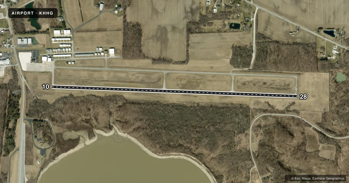
Runways & pattern
Full pagePattern entry · RWY 10
LEFT TRAFFICRunway end performance
| End | TORA | TODA | ASDA | LDA | VGSI | Approach lights | Obstruction |
|---|---|---|---|---|---|---|---|
| 10 | — | — | — | — | PAPI 2-box left(3°) | — | 33', trees, 300' from thr, 240' R of cntrln, slope 3 |
| 28 | — | — | — | — | PAPI 2-box left(3°) | — | 55', trees, 1100' from thr, 0' R of cntrln, slope 16 |
Declared distances in feet. TORA = takeoff run available, TODA = takeoff distance, ASDA = accelerate-stop, LDA = landing distance.
Airport sketch
Runways drawn to scale from FAA survey coordinates, rendered over satellite imagery. Not for navigation.
Approaches & charts
Services on the field
Fuel grades, oxygen, maintenance, ramp storage and lighting — as declared to the FAA by the airport operator.
Fuel & services
- Fuel
- 100LLA
- Oxygen (bottled)
- Not available
- Oxygen (bulk)
- Not available
- Airframe repair
- Major
- Power plant repair
- Major
- Other services
- INSTR,RNTL,SALES
Ramp & ground
- Transient storage
- Tie-down
- Hangar
- Landing fee
- No fee published
- Customs
- Not available
- Lighting schedule
- SEE RMK
- Beacon schedule
- SS-SR
- Beacon
- White / Green (civil land)(WG)
- Wind indicator
- Lighted
- Segmented circle
- No
Fuel & FBOs
Cheapest 100LL and Jet A on the field and nearby. Always confirm with the FBO before taxi.
Airport notes
Surface conditions, obstructions, local procedures, lighting outages and other notes published with each FAA cycle.
General notes
- DEER ON & INVOF ARPT SPCLY MORNING & EVE.
- FOR CD CTC CHICAGO ARTCC AT 630-906-8921.
Lighting notes
- ACTVT REIL RWY 10 & 28; MIRL RWY 1028 - CTAF. MIRL RWY 10/28 PRESET LOW INTST; INCR INTST - CTAF.
Fuel notes
- 100LLSELF SVC AVBL.
Other notes
- THIS AIRPORT HAS BEEN SURVEYED BY THE NATIONAL GEODETIC SURVEY.
- 1UNATNDD HOLIDAYS.
VFR map & nearby airports
VFR sectional. Tap any ICAO chip to open that airport.
Key facts · KHHG
Answer card- ICAO
- KHHG
- Name
- HUNTINGTON MUNI
- Location
- HUNTINGTON, INDIANA
- Elevation
- 805.7 ft MSL
- Traffic pattern altitude
- 1,805.7 ft MSL (1,000 AGL)
- Control tower
- Non-towered (use CTAF)
- Total runways
- 1
- Longest runway
- 10/28 · 5,003 ft
- Published ILS approaches
- 0
- Published frequencies
- 4
- Magnetic variation
- 6°
- Current flight rules
- VFR
- Current wind
- 000° at 0 kt
- Favored runway now
- –
HUNTINGTON MUNI sits in Huntington, Indiana. Field elevation is 805.7 ft MSL. The airport has one runway, 10/28, which is 5,003 ft long. It is a non-towered field. CTAF and UNICOM are both 122.8. Approach and departure service is listed on 127.2 and 284.6 through Fort Wayne. No ILS approaches are published here.
Pattern altitude is not published. Use 1,000 ft AGL for light piston traffic unless the current Chart Supplement says otherwise. Patriot Aviation is on the field. It carries 100LL and Jet A Prist. Self-service 100LL is available. The airport is unattended on holidays. Deer are reported on and near the airport, especially in the morning and evening. That matters here more than at most small fields.
For a first-time arrival, plan for a simple non-towered pattern and keep a sharp lookout for wildlife. The field is not towered, so standard CTAF discipline matters. If you need clearance delivery, contact Chicago ARTCC at 630-906-8921. Check the current Chart Supplement for any published noise or curfew restrictions before flying into the field.