METAR & TAF KGEO
KGEO does not publish a METAR.
Showing the nearest reporting station: KFGX (FLEMING-MASON) · 21.4 NM away. Conditions at KGEO may differ.
METAR · KFGX
Observed 12:15Z
KFGX 271215Z AUTO 00000KT 1 1/4SM BR OVC002 19/19 A2997 RMK AO2 T01900187
- Wind
- 000° @ 0 kt
- Visibility
- 0.25 SM
- Temp / Dew
- 19°C / 19°C
- Altimeter
- 29.97 inHg
- Clouds
- OVC
- Density alt
- 1,605 ft
- Ceiling
- 200 ft AGL
- Rules
- LIFR
Airport info & contacts
Manager on record, flight service, ARTCC, attendance schedule and pattern altitude — published by the FAA and refreshed every 28 days.
Location
- From city
- 1 NM NE
- VFR sectional
- CINCINNATI
- ARTCC
- ZID · INDIANAPOLIS
- NOTAM facility
- DAY (NOTAM-D)
Airport manager
- Name
- STEVE & SANDY MCKINNEY
- Phone
- 937-483-6212
- Address
- 8862 AIRPORT RD, GEORGETOWN OH 45121-8404
Flight service · Hours
- FSS DAY
- DAYTON1-800-WX-BRIEF
- Attendance
- Unattended
Frequencies
Tap any row to copy the frequency to your clipboard.
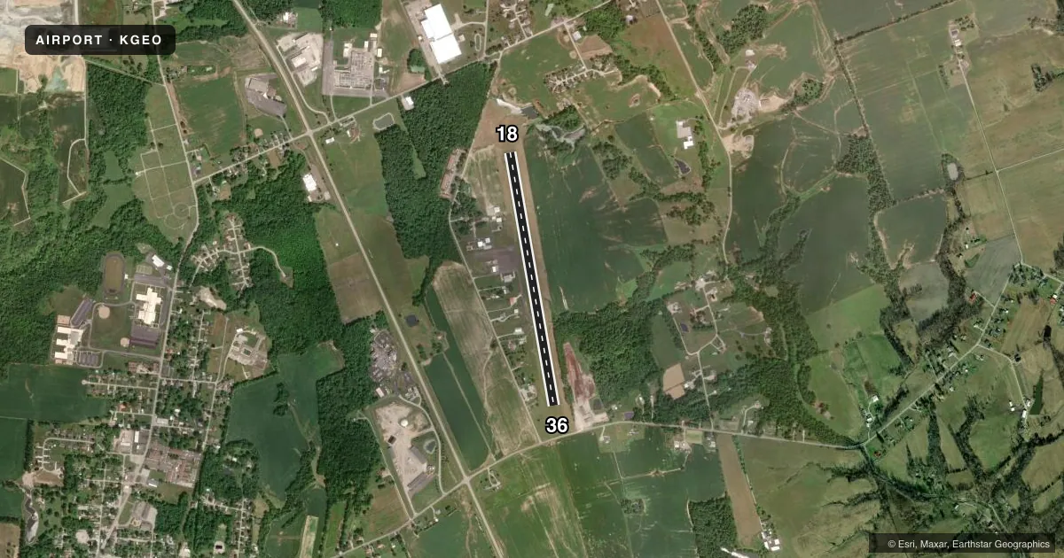
Runways & pattern
Full pagePattern entry · RWY 18
LEFT TRAFFICRunway end performance
| End | TORA | TODA | ASDA | LDA | VGSI | Approach lights | Obstruction |
|---|---|---|---|---|---|---|---|
| 18 | — | — | — | — | PAPI 4-box left(3.03°) | — | 100', trees, 1295' from thr, 215' R of cntrln, slope 10 |
| 36 | — | — | — | — | PAPI 4-box left(3.03°) | — | 45', tree, 260' from thr, 245' R of cntrln, slope 1 |
Declared distances in feet. TORA = takeoff run available, TODA = takeoff distance, ASDA = accelerate-stop, LDA = landing distance.
Airport sketch
Runways drawn to scale from FAA survey coordinates, rendered over satellite imagery. Not for navigation.
Approaches & charts
Services on the field
Fuel grades, oxygen, maintenance, ramp storage and lighting — as declared to the FAA by the airport operator.
Fuel & services
- Fuel
- 100LLUL94
- Oxygen (bottled)
- Not available
- Oxygen (bulk)
- Not available
- Airframe repair
- Minor
- Power plant repair
- Minor
Ramp & ground
- Transient storage
- Tie-down
- Hangar
- Landing fee
- No fee published
- Customs
- Not available
- Lighting schedule
- SEE RMK
- Beacon schedule
- SS-SR
- Beacon
- White / Green (civil land)(WG)
- Wind indicator
- Lighted
- Segmented circle
- No
Fuel & FBOs
Cheapest 100LL and Jet A on the field and nearby. Always confirm with the FBO before taxi.
Airport notes
Surface conditions, obstructions, local procedures, lighting outages and other notes published with each FAA cycle.
General notes
- FOR CD CTC INDIANAPOLIS ARTCC AT 317-247-2411.
Lighting notes
- ACTVT REIL RWY 18 & 36; MIRL RWY 18/36 - CTAF.
Fuel notes
- 100LLFUEL AVBL H24 SELF SVC VIA CREDIT CARD.
Approach & departure obstructions
- 183 FT CROPS, 145 FT DIST, 200 FT L TO 180 FT R.
- 3645-70 FT TREES, 200 FT DIST, 245 FT R.
- 18FADED.
- 36FADED.
- 18ALSO 10 FT ROAD, 300 FT DIST, 0 FT B, APCH RATIO 10:1.
Other notes
- FOR AIRFRAME & POWERPLANT REPAIRS PHONE 937-379-1055.
- THIS AIRPORT HAS BEEN SURVEYED BY THE NATIONAL GEODETIC SURVEY.
- PRIOR CDN RQRD FOR TSNT HNGR.
- ROPES NOT PRVDD.
- MANAGERADNL CTC: HOME 937-379-1634; BUS 937-379-1055; SPMCKINNEY53@GMAIL.COM.
VFR map & nearby airports
VFR sectional. Tap any ICAO chip to open that airport.
Key facts · KGEO
Answer card- ICAO
- KGEO
- Name
- BROWN COUNTY
- Location
- GEORGETOWN, OHIO
- Elevation
- 957.6 ft MSL
- Traffic pattern altitude
- 1,957.6 ft MSL (1,000 AGL)
- Control tower
- Non-towered (use CTAF)
- Total runways
- 1
- Longest runway
- 18/36 · 3,530 ft
- Published ILS approaches
- 0
- Published frequencies
- 1
- Magnetic variation
- 5°
- Current flight rules
- LIFR
- Current wind
- 000° at 0 kt
- Favored runway now
- –
Brown County Airport (KGEO) sits in Georgetown, Ohio at 957.6 ft MSL. It has one asphalt runway, 18/36, at 3,530 ft. There is no control tower. CTAF is 122.9. No ILS approaches are published, so plan with the current chart and weather brief before you go. Pattern altitude is not published. Use the standard 1,000 ft AGL pattern unless local procedures or current guidance say otherwise.
The Brown County Pilots Association is on the field. It carries 100LL and UL94. Self-serve 100LL is available 24 hours with a credit card. Transient hangar use needs prior coordination. Tiedown space is available, but no ropes are provided. The field also has runway end identifier lights on 18 and 36. Medium intensity runway lights are on 18/36 and are controlled by CTAF.
There is a published obstruction note near runway 18. A 10-foot road obstruction sits 300 feet from the threshold, left of centerline. That makes the 18 end worth a close look on departure and arrival. For clearance delivery, contact Indianapolis ARTCC. This is a non-towered airport, so expect self-announce traffic and keep your scan active. If you are planning a first stop here, check the current FAA Chart Supplement for any updates before flight.