METAR & TAF KFGX
Current METAR
Observed 08:15Z
KFGX 270815Z AUTO 00000KT 1 1/4SM BR SCT002 19/19 A2993 RMK AO2 T01890186
- Wind
- 000° @ 0 kt
- Visibility
- 0.25 SM
- Temp / Dew
- 19°C / 19°C
- Altimeter
- 29.93 inHg
- Clouds
- SCT
- Density alt
- 1,600 ft
- Ceiling
- Unlimited
- Rules
- LIFR
Airport info & contacts
Manager on record, flight service, ARTCC, attendance schedule and pattern altitude — published by the FAA and refreshed every 28 days.
Location
- From city
- 7 NM N
- VFR sectional
- CINCINNATI
- ARTCC
- ZID · INDIANAPOLIS
- NOTAM facility
- LOU (NOTAM-D)
Airport manager
- Name
- DERON MULLIKIN
- Phone
- 606-742-2411
- Address
- 7079 AIRPORT RD., MAYSVILLE KY 41056
Flight service · Hours
- FSS LOU
- LOUISVILLE1-800-WX-BRIEF
- Attendance
- MON-FRI · 0800-1700
- SAT · 1000-1600
- SUN · 1100-1600
Frequencies
Tap any row to copy the frequency to your clipboard.
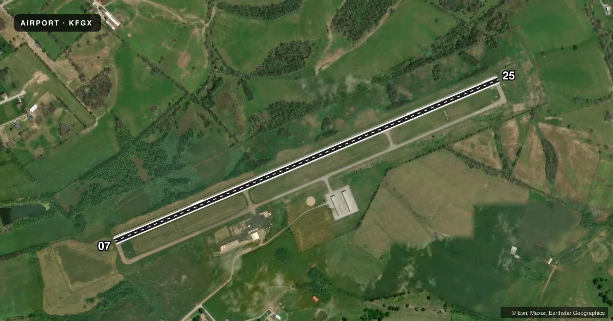
Runways & pattern
Full pagePattern entry · RWY 07
LEFT TRAFFICRunway end performance
| End | TORA | TODA | ASDA | LDA | VGSI | Approach lights | Obstruction |
|---|---|---|---|---|---|---|---|
| 07 | 5,002' | 5,002' | 5,002' | 4,703' | PAPI 4-box right(3°) | — | — |
| 25 | 5,002' | 5,002' | 4,703' | 4,703' | PAPI 4-box left(3°) | — | — |
Declared distances in feet. TORA = takeoff run available, TODA = takeoff distance, ASDA = accelerate-stop, LDA = landing distance.
Airport sketch
Runways drawn to scale from FAA survey coordinates, rendered over satellite imagery. Not for navigation.
Approaches & charts
Services on the field
Fuel grades, oxygen, maintenance, ramp storage and lighting — as declared to the FAA by the airport operator.
Fuel & services
- Fuel
- 100LLA+
- Airframe repair
- Minor
- Power plant repair
- Minor
- Other services
- INSTR,RNTL
Ramp & ground
- Transient storage
- Tie-down
- Hangar
- Landing fee
- No fee published
- Customs
- Not available
- Lighting schedule
- SEE RMK
- Beacon schedule
- SS-SR
- Beacon
- White / Green (civil land)(WG)
- Wind indicator
- Lighted
- Segmented circle
- Yes
Fuel & FBOs
Cheapest 100LL and Jet A on the field and nearby. Always confirm with the FBO before taxi.
Airport notes
Surface conditions, obstructions, local procedures, lighting outages and other notes published with each FAA cycle.
General notes
- FOR CD CTC INDIANAPOLIS ARTCC AT 317-247-2411.
Lighting notes
- ACTVT REIL RWY 07 & 25; PAPI RWY 07 & 25; MIRL RWY 07/25 - CTAF.
Approach & departure obstructions
- 07MARKINGS FADED.
- 25MARKINGS FADED.
Other notes
- 1SVC AFT HR - 606-748-7170.
- OWNERDAVID MAHER
- MANAGERMANAGER'S CELL (606) 541-2957
- OWNERBOARD CHAIR
VFR map & nearby airports
VFR sectional. Tap any ICAO chip to open that airport.
Key facts · KFGX
Answer card- ICAO
- KFGX
- Name
- FLEMING-MASON
- Location
- FLEMINGSBURG, KENTUCKY
- Elevation
- 913.3 ft MSL
- Traffic pattern altitude
- 1,913.3 ft MSL (1,000 AGL)
- Control tower
- Non-towered (use CTAF)
- Total runways
- 1
- Longest runway
- 07/25 · 5,002 ft
- Published ILS approaches
- 0
- Published frequencies
- 2
- Magnetic variation
- 5°
- Current flight rules
- LIFR
- Current wind
- 000° at 0 kt
- Favored runway now
- –
Fleming-Mason Airport (KFGX) sits in Flemingsburg, Kentucky. Field elevation is 913.3 ft MSL. The airport has one runway. Runway 07/25 is 5,002 ft long with an asphalt surface. There is no control tower. CTAF and UNICOM are both 123.0. No ILS approaches are published here.
Pattern altitude is not published. Use the standard 1,000 ft AGL pattern unless the current Chart Supplement or local procedures say otherwise. The published runway lighting includes medium intensity runway lights. Runway end identifier lights and precision approach path indicators are also listed for both ends. Runway markings on 07 and 25 are reported as faded, so plan for a careful visual scan on rollout and lineup.
Fleming-Mason Aviation is on the field. It carries 100LL and Jet A Prist. After-hours service is available by phone. For clearance delivery, the published contact is Indianapolis Center. This is a non-towered airport, so expect self-announce traffic and keep a close ear on CTAF. The runway length is workable for a lot of light aircraft. Still, check density altitude, winds and performance before you go. If you need current operating details, verify them with the airport operator or the FBO directly by phone.