METAR & TAF K62
Current METAR
Observed 11:15Z
KK62 271115Z AUTO 00000KT 7SM CLR 18/17 A2994 RMK AO2
- Wind
- 000° @ 0 kt
- Visibility
- 7 SM
- Temp / Dew
- 18°C / 17°C
- Altimeter
- 29.94 inHg
- Clouds
- CLR
- Density alt
- 1,451 ft
- Ceiling
- Unlimited
- Rules
- VFR
Airport info & contacts
Manager on record, flight service, ARTCC, attendance schedule and pattern altitude — published by the FAA and refreshed every 28 days.
Location
- From city
- 4 NM NW
- VFR sectional
- CINCINNATI
- ARTCC
- ZID · INDIANAPOLIS
- NOTAM facility
- LOU (NOTAM-D)
Airport manager
- Name
- DAN BELL
- Phone
- 859-654-1200
- Address
- 400 GENE SNYDER AIRPORT DRIVE, FALMOUTH KY 41040
Flight service · Hours
- FSS LOU
- LOUISVILLE1-800-WX-BRIEF
- Attendance
- Unattended
Frequencies
Tap any row to copy the frequency to your clipboard.
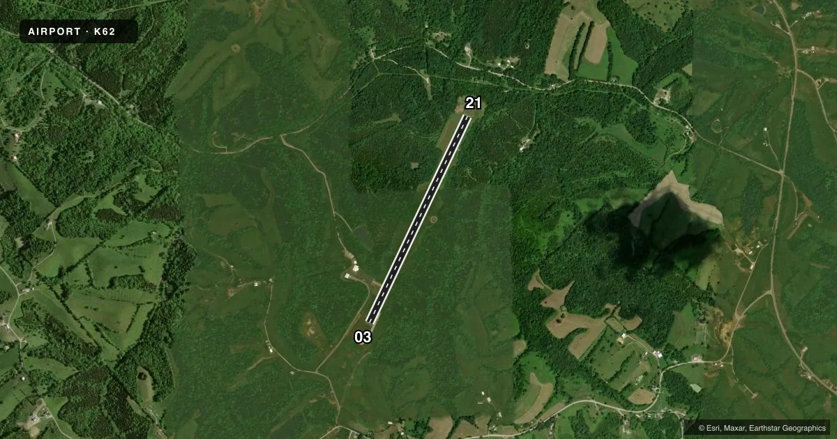
Runways & pattern
Full pagePattern entry · RWY 03
LEFT TRAFFICRunway end performance
| End | TORA | TODA | ASDA | LDA | VGSI | Approach lights | Obstruction |
|---|---|---|---|---|---|---|---|
| 03 | 4,002' | 4,002' | 4,002' | 4,002' | PAPI 2-box left(3°) | — | 51', trees, 655' from thr, 290' R of cntrln, slope 8 |
| 21 | 4,002' | 4,002' | 4,002' | 4,002' | PAPI 2-box left(3.5°) | — | 21', trees, 353' from thr, 243' R of cntrln, slope 7 |
Declared distances in feet. TORA = takeoff run available, TODA = takeoff distance, ASDA = accelerate-stop, LDA = landing distance.
Airport sketch
Runways drawn to scale from FAA survey coordinates, rendered over satellite imagery. Not for navigation.
Approaches & charts
Services on the field
Fuel grades, oxygen, maintenance, ramp storage and lighting — as declared to the FAA by the airport operator.
Fuel & services
- Fuel
- 100LL
- Other services
- INSTR,RNTL
Ramp & ground
- Transient storage
- Tie-down
- Landing fee
- No fee published
- Lighting schedule
- SEE RMK
- Beacon schedule
- SS-SR
- Beacon
- White / Green (civil land)(WG)
- Wind indicator
- Lighted
- Segmented circle
- Yes
Fuel & FBOs
Cheapest 100LL and Jet A on the field and nearby. Always confirm with the FBO before taxi.
Airport notes
Surface conditions, obstructions, local procedures, lighting outages and other notes published with each FAA cycle.
General notes
- FOR CD CTC CINCINNATI APCH AT 859-372-6440
Lighting notes
- ACTVT REIL RWY 03 & 21; PAPI RWY 03 & 21; MIRL RWY 03/21 - CTAF.
Approach & departure obstructions
- 21+8 TREES AT RWY END 155 FT R OF CNTRLN.
- 21PAPI UNUSBL BYD 8 DEGS LEFT & 6 DEGS RIGHT OF CNTRLN.
VFR map & nearby airports
VFR sectional. Tap any ICAO chip to open that airport.
Key facts · K62
Answer card- ICAO
- K62
- Name
- GENE SNYDER
- Location
- FALMOUTH, KENTUCKY
- Elevation
- 899.7 ft MSL
- Traffic pattern altitude
- 1,899.7 ft MSL (1,000 AGL)
- Control tower
- Non-towered (use CTAF)
- Total runways
- 1
- Longest runway
- 03/21 · 4,002 ft
- Published ILS approaches
- 0
- Published frequencies
- 4
- Magnetic variation
- 6°
- Current flight rules
- VFR
- Current wind
- 000° at 0 kt
- Favored runway now
- –
Gene Snyder Airport sits in Falmouth, Kentucky. The field elevation is 899.7 ft MSL. It has one runway, 03/21, which is 4,002 ft long. There is no control tower. Pattern altitude is not published, so use the standard 1,000 ft AGL for light piston operations unless the current Chart Supplement says otherwise.
No ILS approaches are published here. Clearance delivery is handled through Cincinnati Approach. The published approach frequencies are 121.0 and 254.25 MHz. CTAF and UNICOM are both 122.7. The on-field FBO is Gene Snyder Airport. It carries 100LL. Call (859) 654-1200 before you go if you need current service details.
A few published remarks matter on a first visit. The PAPI on runway 21 is only usable close to centerline. There are 8-foot trees near the runway end on the right side of runway 21. Runway end identifier lights are installed on both ends. Medium intensity runway lights are available on runway 03/21 and are controlled by CTAF. This is an untowered field, so expect self-announce traffic and stay sharp on the radio. Check the current Chart Supplement for any updated procedures before flying in.