METAR & TAF 8GK
8GK does not publish a METAR.
Showing the nearest reporting station: KCVG (CINCINNATI/NORTHERN KENTUCKY INTL) · 25.3 NM away. Conditions at 8GK may differ.
METAR · KCVG
Observed 04:52Z
KCVG 270452Z 00000KT 10SM FEW060 SCT250 22/20 A2993 RMK AO2 SLP126 T02220200 402720194
- Wind
- 000° @ 0 kt
- Visibility
- 10 SM
- Temp / Dew
- 22°C / 20°C
- Altimeter
- 29.93 inHg
- Clouds
- SCT
- Density alt
- 1,857 ft
- Ceiling
- Unlimited
- Rules
- VFR
Airport info & contacts
Manager on record, flight service, ARTCC, attendance schedule and pattern altitude — published by the FAA and refreshed every 28 days.
Location
- From city
- 1 NM N
- VFR sectional
- CINCINNATI
- ARTCC
- ZID · INDIANAPOLIS
- NOTAM facility
- 8GK
Airport manager
- Name
- JON MORRIS
- Phone
- 859-206-3722
- Address
- PO BOX 144, WARSAW KY 41095
Flight service · Hours
- FSS LOU
- LOUISVILLE1-800-WX-BRIEF
Frequencies
Tap any row to copy the frequency to your clipboard.
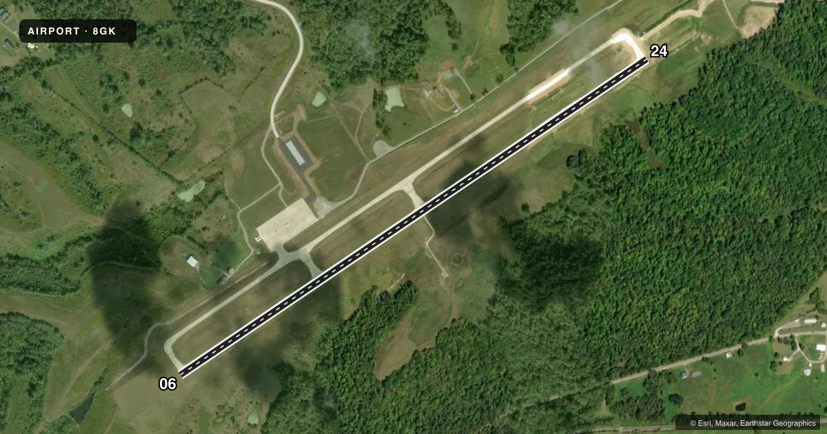
Runways & pattern
Full pagePattern entry · RWY 06
LEFT TRAFFICAirport sketch
Runways drawn to scale from FAA survey coordinates, rendered over satellite imagery. Not for navigation.
Approaches & charts
Services on the field
Fuel grades, oxygen, maintenance, ramp storage and lighting — as declared to the FAA by the airport operator.
Fuel & services
- Fuel
- 100LLA
Ramp & ground
- Transient storage
- Not published
- Beacon
- White / Green (civil land)(WG)
- Wind indicator
- Yes
- Segmented circle
- Yes
Fuel & FBOs
Cheapest 100LL and Jet A on the field and nearby. Always confirm with the FBO before taxi.
Airport notes
Surface conditions, obstructions, local procedures, lighting outages and other notes published with each FAA cycle.
Runway surface & condition
- 06/24PCR VALUE: 310/R/C/W/T
Other notes
- OWNERCO JUDGE LANDLINE.
VFR map & nearby airports
VFR sectional. Tap any ICAO chip to open that airport.
Key facts · 8GK
Answer card- ICAO
- 8GK
- Name
- GALLATIN COUNTY
- Location
- SPARTA, KENTUCKY
- Elevation
- 830.4 ft MSL
- Traffic pattern altitude
- 1,830.4 ft MSL (1,000 AGL)
- Control tower
- Non-towered (use CTAF)
- Total runways
- 1
- Longest runway
- 06/24 · 5,000 ft
- Published ILS approaches
- 0
- Published frequencies
- 1
- Magnetic variation
- –
- Current flight rules
- VFR
- Current wind
- 000° at 0 kt
- Favored runway now
- –
Gallatin County Airport (8GK) is in Sparta, Kentucky. The field elevation is 830.4 ft MSL. It has one runway. Runway 06/24 is 5,000 ft long with concrete pavement. This is an untowered field, so plan to self-announce on CTAF 122.9 and keep your scan sharp in the pattern.
No ILS approaches are published here. The pattern altitude is not published in the facts, so use the current FAA Chart Supplement before you go. For runway 06/24, the published notes include a pavement classification number of 310 rigid, commercial, with tire. The remarks also point to the county judge landline for the owner contact. That is useful if you need airport-specific coordination before arrival.
There are no on-field FBOs listed in the facts. Verify fuel and services with the airport operator or call the field directly before departure. For a first-time arrival, the main things to know are the single runway layout, the lack of tower services and the need to confirm current pattern and local procedures in the Chart Supplement. The airport sits in northern Kentucky, so review the current chart for any airspace or traffic considerations before flying in.