METAR & TAF KFFT
Current METAR
Observed 12:53Z
KFFT 271253Z AUTO A2995 RMK AO2 SLPNO PWINO PNO $
- Wind
- Calm
- Visibility
- —
- Temp / Dew
- —
- Altimeter
- 29.95 inHg
- Clouds
- Clear
- Density alt
- —
- Ceiling
- Unlimited
- Rules
- VFR
Airport info & contacts
Manager on record, flight service, ARTCC, attendance schedule and pattern altitude — published by the FAA and refreshed every 28 days.
Location
- From city
- 1 NM SW
- VFR sectional
- CINCINNATI
- ARTCC
- ZID · INDIANAPOLIS
- NOTAM facility
- FFT (NOTAM-D)
Airport manager
- Name
- DREW UNDERWOOD
- Phone
- 502-564-0339
- Address
- 88 AIRPORT ROAD, FRANKFORT KY 40601
Flight service · Hours
- FSS LOU
- LOUISVILLE1-800-WX-BRIEF
- Attendance
- MON-FRI · 0700-2000
- SAT-SUN · 0900-1800
Frequencies
Tap any row to copy the frequency to your clipboard.
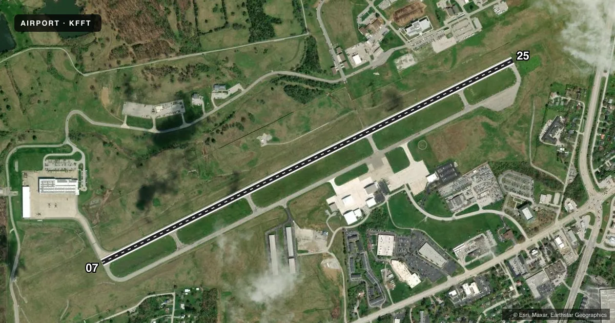
Runways & pattern
Full pagePattern entry · RWY 07
LEFT TRAFFICRunway end performance
| End | TORA | TODA | ASDA | LDA | VGSI | Approach lights | Obstruction |
|---|---|---|---|---|---|---|---|
| 07 | — | — | — | — | PAPI 4-box left(3°) | — | 58', tree, 1684' from thr, 472' R of cntrln, slope 25 |
| 25 | — | — | — | — | PAPI 4-box left(3.5°) | — | 50', tree, 1721' from thr, 355' R of cntrln, slope 30 |
Declared distances in feet. TORA = takeoff run available, TODA = takeoff distance, ASDA = accelerate-stop, LDA = landing distance.
Airport sketch
Runways drawn to scale from FAA survey coordinates, rendered over satellite imagery. Not for navigation.
Approaches & charts
ILS · 1
Services on the field
Fuel grades, oxygen, maintenance, ramp storage and lighting — as declared to the FAA by the airport operator.
Fuel & services
- Fuel
- 100LLA+
- Airframe repair
- Major
- Power plant repair
- Major
- Other services
- INSTR
Ramp & ground
- Transient storage
- Tie-down
- Hangar
- Landing fee
- No fee published
- Customs
- Not available
- Lighting schedule
- SEE RMK
- Beacon schedule
- SS-SR
- Beacon
- White / Green (civil land)(WG)
- Wind indicator
- Yes
- Segmented circle
- Yes
Fuel & FBOs
Cheapest 100LL and Jet A on the field and nearby. Always confirm with the FBO before taxi.
Airport notes
Surface conditions, obstructions, local procedures, lighting outages and other notes published with each FAA cycle.
General notes
- CAUTION: DANIEL BOONE HELI 1/2 NM N OF RWY 25 THR; MIL HEL TFC OPS N OF RWY.
- DEER & BIRDS ON & INVOF ARPT.
- MIL HEL USE RIGHT BASE TO RWY 25.
- PVT AP WITH TURF RWY LCTD 3/4 NM NW OF RWY 07 THR.
- NOISE ABATEMENT PROCS: RWY 7 DEPG ACFT MNTN RWY HDG TO 1800 FT MSL BFR TURNING.
- MILITARY: ARNG OPS - UHF FREQ 226.55
- CTC ANG OPS 42.25/139.35/226.6.
Lighting notes
- ACTVT REIL RWY 07 & 25; PAPI RWY 07 & 25; MIRL RWY 07/25 - CTAF.
Approach & departure obstructions
- 25PAPI RWY 25 UNUSBL BYD 8 DEGS RIGHT OF CNTRLN.
Other notes
- MANAGERMANAGER'S CELL (502) 545-8111
VFR map & nearby airports
VFR sectional. Tap any ICAO chip to open that airport.
Key facts · KFFT
Answer card- ICAO
- KFFT
- Name
- CAPITAL CITY
- Location
- FRANKFORT, KENTUCKY
- Elevation
- 812.5 ft MSL
- Traffic pattern altitude
- 1,812.5 ft MSL (1,000 AGL)
- Control tower
- Non-towered (use CTAF)
- Total runways
- 1
- Longest runway
- 07/25 · 5,506 ft
- Published ILS approaches
- 1
- Published frequencies
- 5
- Magnetic variation
- 5°
- Current flight rules
- VFR
- Current wind
- Calm / unavailable
- Favored runway now
- –
Capital City Airport is in Frankfort, Kentucky. The field elevation is 812.5 ft MSL. It has one runway, 07/25, which is 5,506 ft long. There is no control tower, so use CTAF 122.8 for self-announced traffic. The airport has one ILS approach to runway 25. Pattern altitude is not published in the facts, so plan on the standard 1,000 ft AGL for light piston operations unless the current FAA Chart Supplement says otherwise.
The on-field FBO is Capital City Airport. It carries 100LL and Jet A with Prist. Call (502) 564-3714 for current service details before you go. Published remarks matter here. Departures from runway 07 need to stay on runway heading to 1,800 ft MSL before turning. The runway 25 PAPI is unusable more than 8 degrees right of centerline. Military helicopter traffic works north of the runway. Deer and birds are also reported on and near the field.
This is an uncontrolled airport with mixed traffic, so keep your scan up. Expect helicopter activity near the north side. If you need current noise or operating restrictions, check the current FAA Chart Supplement before flying in.