METAR & TAF KBRY
Current METAR
Observed 12:55Z
KBRY 271255Z AUTO 18004KT 10SM SCT003 BKN050 23/23 A2992 RMK AO2 T02290229 $
- Wind
- 180° @ 4 kt
- Visibility
- 10 SM
- Temp / Dew
- 23°C / 23°C
- Altimeter
- 29.92 inHg
- Clouds
- BKN
- Density alt
- 1,790 ft
- Ceiling
- 5,000 ft AGL
- Rules
- VFR
Airport info & contacts
Manager on record, flight service, ARTCC, attendance schedule and pattern altitude — published by the FAA and refreshed every 28 days.
Location
- From city
- 2 NM W
- VFR sectional
- ST LOUIS
- ARTCC
- ZID · INDIANAPOLIS
- NOTAM facility
- BRY (NOTAM-D)
Airport manager
- Name
- REX HOUCK
- Phone
- 502-348-7858
- Address
- 1924 BOSTON ROAD, BARDSTOWN KY 40004
Flight service · Hours
- FSS LOU
- LOUISVILLE1-800-WX-BRIEF
- Attendance
- MON-SAT · 0800-1700
- SUN · Unattended
Frequencies
Tap any row to copy the frequency to your clipboard.
Runways & pattern
Full pagePattern entry · RWY 21
LEFT TRAFFICRunway end performance
| End | TORA | TODA | ASDA | LDA | VGSI | Approach lights | Obstruction |
|---|---|---|---|---|---|---|---|
| 03 | — | — | — | — | PAPI 2-box left(3.5°) | — | 11', pole, 251' from thr, 251' R of cntrln, slope 4 |
| 21 | — | — | — | — | PAPI 2-box left(3°) | — | 70', tree, 2354' from thr, 322' R of cntrln, slope 30 |
Declared distances in feet. TORA = takeoff run available, TODA = takeoff distance, ASDA = accelerate-stop, LDA = landing distance.
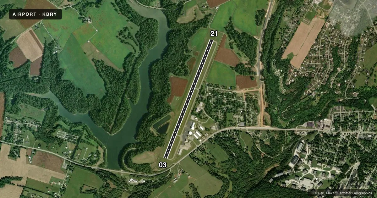
Airport sketch
Runways drawn to scale from FAA survey coordinates, rendered over satellite imagery. Not for navigation.
Approaches & charts
Services on the field
Fuel grades, oxygen, maintenance, ramp storage and lighting — as declared to the FAA by the airport operator.
Fuel & services
- Fuel
- 100LLA+
- Oxygen (bulk)
- Not available
- Airframe repair
- Minor
- Power plant repair
- Minor
- Other services
- AVNCS,CARGO,INSTR,RNTL
Ramp & ground
- Transient storage
- Tie-down
- Hangar
- Landing fee
- No fee published
- Customs
- Not available
- Lighting schedule
- SEE RMK
- Beacon schedule
- SS-SR
- Beacon
- White / Green (civil land)(WG)
- Wind indicator
- Lighted
- Segmented circle
- Yes
Fuel & FBOs
Cheapest 100LL and Jet A on the field and nearby. Always confirm with the FBO before taxi.
Airport notes
Surface conditions, obstructions, local procedures, lighting outages and other notes published with each FAA cycle.
General notes
- FOR CD CTC LOUISVILLE APCH AT 502-375-7499
Lighting notes
- ACTVT REIL RWY 03 & 21; PAPI RWY 03 & 21; MIRL RWY 3/21 - CTAF.
Other notes
- 4CALL OUT AVBL - 502-348-7858 (LANDLINE; RINGS OVER TO CELL).
- OWNERDAVID MATTINGLY
- MANAGERLANDLINE.
VFR map & nearby airports
VFR sectional. Tap any ICAO chip to open that airport.
Key facts · KBRY
Answer card- ICAO
- KBRY
- Name
- SAMUELS FLD
- Location
- BARDSTOWN, KENTUCKY
- Elevation
- 669.3 ft MSL
- Traffic pattern altitude
- 1,669.3 ft MSL (1,000 AGL)
- Control tower
- Non-towered (use CTAF)
- Total runways
- 1
- Longest runway
- 03/21 · 5,003 ft
- Published ILS approaches
- 0
- Published frequencies
- 4
- Magnetic variation
- 5°
- Current flight rules
- VFR
- Current wind
- 180° at 4 kt
- Favored runway now
- RWY 21
Samuels Fld is in Bardstown, Kentucky. The field elevation is 668.8 ft MSL. It has one runway, 03/21, which is 5,003 ft long. There is no control tower. Pattern altitude is not published, so use the standard 1,000 ft AGL for light piston operations unless the current Chart Supplement says otherwise.
No ILS approaches are published here. Runway 03/21 has medium intensity runway lights, runway end identifier lights and PAPI on both ends. The lights are controlled by CTAF. CTAF and UNICOM are both 122.8. Louisville Approach handles approach and departure services on 132.075 and 327.0. For clearance delivery, the published contact is Louisville Approach at 502-375-7499.
Samuels Field Aviation is on the field. It carries 100LL and Jet A. The published remarks also list David Mattingly as the owner. The call-out number is 502-348-7858. That number rings over to a cell phone.
For a first-time arrival, the main things to plan for are the non-towered pattern, the published lighting setup and the lack of ILS. Check the current FAA Chart Supplement for any changes before you go. If you need current field details, call the airport operator or Samuels Field Aviation directly by phone.