METAR & TAF KDVK
Current METAR
Observed 22:50Z
KDVK 262250Z AUTO 32003KT 10SM BKN023 OVC034 27/22 A2994 RMK AO2
- Wind
- 320° @ 3 kt
- Visibility
- 10 SM
- Temp / Dew
- 27°C / 22°C
- Altimeter
- 29.94 inHg
- Clouds
- OVC
- Density alt
- 2,682 ft
- Ceiling
- 2,300 ft AGL
- Rules
- MVFR
Airport info & contacts
Manager on record, flight service, ARTCC, attendance schedule and pattern altitude — published by the FAA and refreshed every 28 days.
Location
- From city
- 3 NM S
- VFR sectional
- CINCINNATI
- ARTCC
- ZID · INDIANAPOLIS
- NOTAM facility
- LOU (NOTAM-D)
Airport manager
- Name
- CHRISTIAN BARKER
- Phone
- 859-854-5994
- Address
- 420 AIRPORT ROAD, DANVILLE KY 40422-9424
Flight service · Hours
- FSS LOU
- LOUISVILLE1-800-WX-BRIEF
- Attendance
- 0700-1800
Frequencies
Tap any row to copy the frequency to your clipboard.
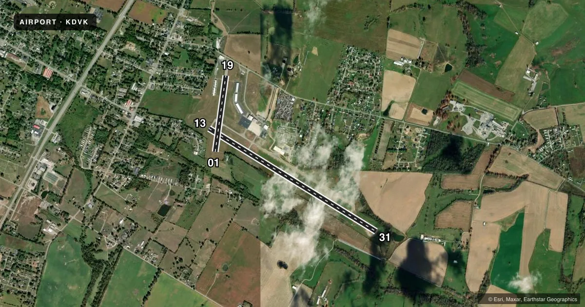
Runways & pattern
Full pagePattern entry · RWY 31
LEFT TRAFFIC| Runway | Heading (°M) | Length | Surface | Traffic |
|---|---|---|---|---|
| 13/31Favored | 119° / 299° | 5,000 ft | ASPH | Standard L |
| 01/19 | 5° / 185° | 1,956 ft | ASPH | Standard L |
Runway end performance
| End | TORA | TODA | ASDA | LDA | VGSI | Approach lights | Obstruction |
|---|---|---|---|---|---|---|---|
| 13 | — | — | — | — | PAPI 4-box left(3°) | — | 38', trees, 355' from thr, 248' R of cntrln, slope 4 |
| 31 | — | — | — | — | PAPI 4-box left(3°) | — | — |
| 01 | — | — | — | — | — | — | 64', trees, 671' from thr, 136' R of cntrln, slope 7 |
| 19 | — | — | — | — | — | — | 27', hangar, 429' from thr, 107' R of cntrln, slope 8 |
Declared distances in feet. TORA = takeoff run available, TODA = takeoff distance, ASDA = accelerate-stop, LDA = landing distance.
Airport sketch
Runways drawn to scale from FAA survey coordinates, rendered over satellite imagery. Not for navigation.
Approaches & charts
ILS · 1
Services on the field
Fuel grades, oxygen, maintenance, ramp storage and lighting — as declared to the FAA by the airport operator.
Fuel & services
- Fuel
- 100LLA+
- Airframe repair
- Major
- Power plant repair
- Major
- Other services
- AMB,CARGO,CHTR,INSTR,RNTL
Ramp & ground
- Transient storage
- Tie-down
- Hangar
- Landing fee
- No fee published
- Customs
- Not available
- Lighting schedule
- SEE RMK
- Beacon schedule
- SS-SR
- Beacon
- White / Green (civil land)(WG)
- Wind indicator
- Lighted
- Segmented circle
- Yes
Fuel & FBOs
Cheapest 100LL and Jet A on the field and nearby. Always confirm with the FBO before taxi.
Airport notes
Surface conditions, obstructions, local procedures, lighting outages and other notes published with each FAA cycle.
General notes
- FOR CD CTC LEXINGTON APPROACH AT 859-514-7890.
Lighting notes
- ACTVT REIL RWY 31; PAPI RWY 13 & 31; MIRL RWY 13/31 - CTAF.
Approach & departure obstructions
- 016 FT FENCE 196 FT FM THR.
- 13TREE 184 FT FM RWY END 247 FT R OF CNTRLN.
- 31TREES WI 200 FT R OF RWY END.
- 1920:1 TO DTHR.
Other notes
- MANAGERNICK BARKER 859-853-1701
- OWNERROB CALDWELL 859-319-9414.
VFR map & nearby airports
VFR sectional. Tap any ICAO chip to open that airport.
Key facts · KDVK
Answer card- ICAO
- KDVK
- Name
- STUART POWELL FLD
- Location
- DANVILLE, KENTUCKY
- Elevation
- 1,021.4 ft MSL
- Traffic pattern altitude
- 2,021.4 ft MSL (1,000 AGL)
- Control tower
- Non-towered (use CTAF)
- Total runways
- 2
- Longest runway
- 13/31 · 5,000 ft
- Published ILS approaches
- 1
- Published frequencies
- 4
- Magnetic variation
- 3°
- Current flight rules
- MVFR
- Current wind
- 320° at 3 kt
- Favored runway now
- RWY 31
Stuart Powell Fld is in Danville, Kentucky. The field elevation is 1,021.4 ft MSL. It has two asphalt runways. The longest is runway 13/31 at 5,000 ft. There is no control tower. CTAF and UNICOM are both 122.8. Lexington Approach handles approach and departure on 120.15 and 259.3.
Runway 31 has the ILS. Runways 13 and 31 have PAPI. Runway 31 also has runway end identifier lights. The published pattern altitude is not listed, so use the standard 1,000 ft AGL for light piston traffic unless the current FAA Chart Supplement says otherwise. That puts the pattern at about 2,021.4 ft MSL based on the field elevation.
Danville Boyle County Airport is on the field. It carries 100LL and Jet A with Prist. Call the FBO directly at (859) 854-5994 for current service details. The remarks also note a tree near the departure end of runway 13. They note a fence near the threshold of runway 01. Trees near the right side of runway 31 are also published. Runway 19 has a 20 to 1 obstacle clearance slope to the displaced threshold. For clearance delivery, contact Lexington Approach. First-time arrivals should plan for a non-towered field with published lighting on 13/31. Pay close attention to the obstacle notes on the shorter runway ends.