METAR & TAF KSME
Current METAR
Observed 17:55Z
KSME 261755Z AUTO VRB07KT 210V280 10SM SCT025 BKN034 29/26 A2997 RMK AO2
- Wind
- VAR @ 7 kt
- Visibility
- 10 SM
- Temp / Dew
- 29°C / 26°C
- Altimeter
- 29.97 inHg
- Clouds
- BKN
- Density alt
- 2,768 ft
- Ceiling
- 3,400 ft AGL
- Rules
- VFR
Airport info & contacts
Manager on record, flight service, ARTCC, attendance schedule and pattern altitude — published by the FAA and refreshed every 28 days.
Location
- From city
- 3 NM S
- VFR sectional
- CINCINNATI
- ARTCC
- ZID · INDIANAPOLIS
- NOTAM facility
- SME (NOTAM-D)
Airport manager
- Name
- KELLIE BAKER
- Phone
- 606-679-7908
- Address
- 500 W.O. NEWELL DRIVE, SOMERSET KY 42501
Flight service · Hours
- FSS LOU
- LOUISVILLE1-800-WX-BRIEF
- Attendance
- MON-FRI · 0700-1800
- SAT-SUN · 0800-1800
Frequencies
Tap any row to copy the frequency to your clipboard.
Runways & pattern
Full pagePattern entry · RWY 05
LEFT TRAFFICRunway end performance
| End | TORA | TODA | ASDA | LDA | VGSI | Approach lights | Obstruction |
|---|---|---|---|---|---|---|---|
| 05 | 5,800' | 5,800' | 5,800' | 5,287' | PAPI 2-box right(3°) | — | 13', tree, 289' from thr, 32' R of cntrln, slope 6 |
| 23 | 5,800' | 5,800' | 5,800' | 5,500' | PAPI 2-box left(3°) | — | 17', tree, 281' from thr, 317' R of cntrln, slope 4 |
Declared distances in feet. TORA = takeoff run available, TODA = takeoff distance, ASDA = accelerate-stop, LDA = landing distance.
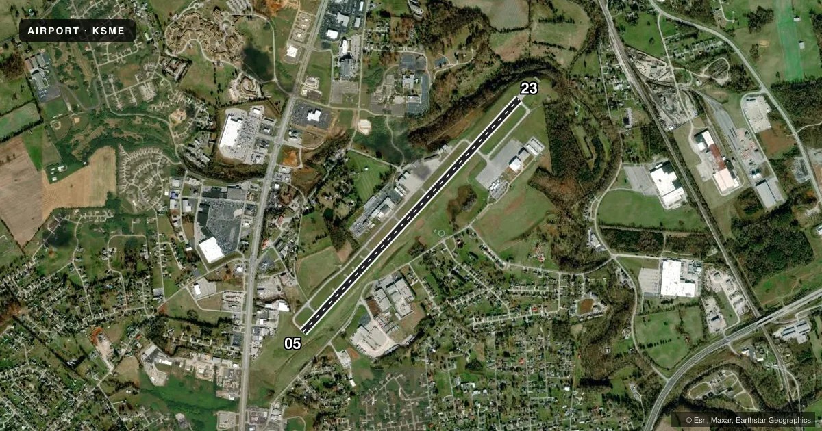
Airport sketch
Runways drawn to scale from FAA survey coordinates, rendered over satellite imagery. Not for navigation.
Approaches & charts
ILS · 1
Services on the field
Fuel grades, oxygen, maintenance, ramp storage and lighting — as declared to the FAA by the airport operator.
Fuel & services
- Fuel
- 100LLA+
- Airframe repair
- Minor
- Power plant repair
- Minor
- Other services
- AMB
Ramp & ground
- Transient storage
- Tie-down
- Hangar
- Landing fee
- No fee published
- Customs
- Not available
- Lighting schedule
- SEE RMK
- Beacon schedule
- SS-SR
- Beacon
- White / Green (civil land)(WG)
- Wind indicator
- Lighted
- Segmented circle
- Yes
Fuel & FBOs
Cheapest 100LL and Jet A on the field and nearby. Always confirm with the FBO before taxi.
Airport notes
Surface conditions, obstructions, local procedures, lighting outages and other notes published with each FAA cycle.
General notes
- FOR CD CTC INDIANAPOLIS ARTCC AT 317-247-2411.
Lighting notes
- ACTVT REIL RWY 05 & 23; PAPI RWY 05 & 23; MIRL RWY 05/23 - CTAF.
Approach & departure obstructions
- 05APCH RATIO 18:1 TO DTHR.
- 23APCH RATIO 8:1 TO DTHR.
Other notes
- INDEX A ARFF EQUIP AVBL ON REQ. CLSD TO UNSKED ACR OPS MORE THAN 30 PAX SEATS.
VFR map & nearby airports
VFR sectional. Tap any ICAO chip to open that airport.
Key facts · KSME
Answer card- ICAO
- KSME
- Name
- LAKE CUMBERLAND RGNL
- Location
- SOMERSET, KENTUCKY
- Elevation
- 927.3 ft MSL
- Traffic pattern altitude
- 1,927.3 ft MSL (1,000 AGL)
- Control tower
- Non-towered (use CTAF)
- Total runways
- 1
- Longest runway
- 05/23 · 5,801 ft
- Published ILS approaches
- 1
- Published frequencies
- 2
- Magnetic variation
- 5°
- Current flight rules
- VFR
- Current wind
- 000° at 7 kt
- Favored runway now
- RWY 05
Lake Cumberland Rgnl sits in Somerset, Kentucky. The field elevation is 927.3 ft MSL. It has one runway. Runway 05/23 is 5,801 ft long and asphalt. The airport is not towered. CTAF and UNICOM are both 122.8. The published ILS is for runway 05.
Pattern altitude is not published. Use the standard 1,000 ft AGL pattern unless the current Chart Supplement says otherwise. That puts the light piston pattern at about 1,927.3 ft MSL. The on-field FBO is Lake Cumberland Regional Airport. It carries 100LL and Jet A. Call the FBO directly at (606) 679-7908 for current services.
A few published remarks matter here. Runway end identifier lights and PAPI are installed on both runway ends. Medium intensity runway lighting is controlled on CTAF. The airport also notes ARFF equipment is available on request. The field is closed to unscheduled air carrier operations with more than 30 passenger seats. For clearance delivery, contact Indianapolis ARTCC. The runway 05 and 23 approach slope notes also suggest you should pay attention to threshold and approach path clearance on both ends. Check the current Chart Supplement before arrival for any local operating notes.