METAR & TAF K24
Current METAR
Observed 06:15Z
KK24 270615Z AUTO 00000KT 7SM CLR 22/21 A2993 RMK AO2 T02220211
- Wind
- 000° @ 0 kt
- Visibility
- 7 SM
- Temp / Dew
- 22°C / 21°C
- Altimeter
- 29.93 inHg
- Clouds
- CLR
- Density alt
- 2,080 ft
- Ceiling
- Unlimited
- Rules
- VFR
Airport info & contacts
Manager on record, flight service, ARTCC, attendance schedule and pattern altitude — published by the FAA and refreshed every 28 days.
Location
- From city
- 2 NM NW
- VFR sectional
- ST LOUIS
- ARTCC
- ZID · INDIANAPOLIS
- NOTAM facility
- LOU (NOTAM-D)
Airport manager
- Name
- BRAXTON SMITH
- Phone
- 270-566-6010
- Address
- 628 C SMITH ROAD, RUSSELL SPRINGS KY 42629
Flight service · Hours
- FSS LOU
- LOUISVILLE1-800-WX-BRIEF
- Attendance
- 0900-1700
Frequencies
Tap any row to copy the frequency to your clipboard.
Runways & pattern
Full pagePattern entry · RWY 17
LEFT TRAFFICRunway end performance
| End | TORA | TODA | ASDA | LDA | VGSI | Approach lights | Obstruction |
|---|---|---|---|---|---|---|---|
| 17 | — | — | — | — | PAPI 4-box left(3°) | — | 118', trees, 3883' from thr, 69' R of cntrln, slope 31 |
| 35 | — | — | — | — | PAPI 4-box left(3°) | — | 60', trees, 1801' from thr, 457' R of cntrln, slope 26 |
Declared distances in feet. TORA = takeoff run available, TODA = takeoff distance, ASDA = accelerate-stop, LDA = landing distance.
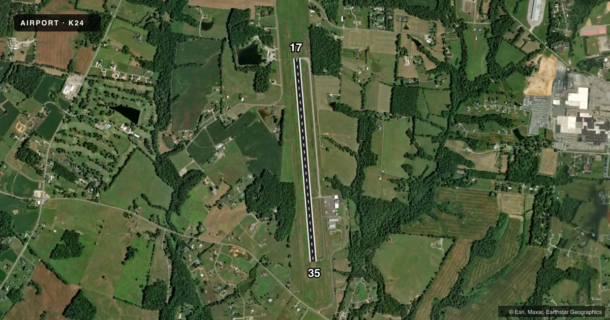
Airport sketch
Runways drawn to scale from FAA survey coordinates, rendered over satellite imagery. Not for navigation.
Approaches & charts
Services on the field
Fuel grades, oxygen, maintenance, ramp storage and lighting — as declared to the FAA by the airport operator.
Fuel & services
- Fuel
- 100LLA+
Ramp & ground
- Transient storage
- Tie-down
- Lighting schedule
- SEE RMK
- Beacon schedule
- SS-SR
- Beacon
- White / Green (civil land)(WG)
- Wind indicator
- Lighted
- Segmented circle
- Yes
Fuel & FBOs
Cheapest 100LL and Jet A on the field and nearby. Always confirm with the FBO before taxi.
Airport notes
Surface conditions, obstructions, local procedures, lighting outages and other notes published with each FAA cycle.
General notes
- CTN: DRAG STRIP 1 MI NE MAY BE MISTAKEN FOR RWY.
- FOR CD CTC INDIANAPOLIS ARTCC AT 317-247-2411.
Lighting notes
- ACTVT REIL RWY 17 & 35; PAPI RWY 17 & 35; MIRL RWY 17/35 - CTAF.
Fuel notes
- 100LLAVBL H24 WITH CREDIT CARD.
Other notes
- PROVIDED VFR ONLY; CLEAR 20:1 APCH SLOPE FOR EACH RY; RUSSEL COUNTY ARPT RUSSELL SPRINGS KY CLOSED CONCURRENTLY; ARPT DESIGNED IAW AC 150/4300-13.
VFR map & nearby airports
VFR sectional. Tap any ICAO chip to open that airport.
Key facts · K24
Answer card- ICAO
- K24
- Name
- RUSSELL COUNTY
- Location
- JAMESTOWN, KENTUCKY
- Elevation
- 1,010.3 ft MSL
- Traffic pattern altitude
- 2,010.3 ft MSL (1,000 AGL)
- Control tower
- Non-towered (use CTAF)
- Total runways
- 1
- Longest runway
- 17/35 · 5,010 ft
- Published ILS approaches
- 0
- Published frequencies
- 2
- Magnetic variation
- 4°
- Current flight rules
- VFR
- Current wind
- 000° at 0 kt
- Favored runway now
- –
Russell County Airport sits in Jamestown, Kentucky at 1,010.3 ft MSL. It has one runway. Runway 17/35 is 5,010 ft long with an asphalt surface. There is no control tower. CTAF and UNICOM are both 123.0.
No ILS approaches are published here. The field is set up for VFR use only. Pattern altitude is not published, so use the standard 1,000 ft AGL for light piston traffic unless the current Chart Supplement says otherwise. The runway lighting setup is useful to know. Runway end identifier lights are installed on 17 and 35. PAPI is also installed on both ends. Medium intensity runway lights are on runway 17/35 and are controlled by the common traffic advisory frequency.
Russell County Airport is home to Russell County Airport FBO. It carries 100LL and Jet A. 100LL is available 24 hours a day with a credit card. One operational note matters here. Clear a 20 to 1 approach slope for each runway. A drag strip sits about 1 mile northeast and may be mistaken for the runway. For clearance delivery, contact Indianapolis ARTCC at 317-247-2411. The airport is in a non-towered environment, so keep your radio calls tight and watch for local traffic.