METAR & TAF KEKQ
Current METAR
Observed 10:30Z
KEKQ 271030Z AUTO 00000KT 1/4SM FG OVC002 21/ A2997 RMK AO2 RVRNO PNO $
- Wind
- 000° @ 0 kt
- Visibility
- 0.25 SM
- Temp / Dew
- —
- Altimeter
- 29.97 inHg
- Clouds
- OVC
- Density alt
- —
- Ceiling
- 200 ft AGL
- Rules
- LIFR
Airport info & contacts
Manager on record, flight service, ARTCC, attendance schedule and pattern altitude — published by the FAA and refreshed every 28 days.
Location
- From city
- 2 NM N
- VFR sectional
- CINCINNATI
- ARTCC
- ZID · INDIANAPOLIS
- NOTAM facility
- LOU (NOTAM-D)
Airport manager
- Name
- JERRY HAMPTON
- Phone
- (661) 205-6415
- Address
- 519 AIRPORT ROAD, MONTICELLO KY 42633
Flight service · Hours
- FSS LOU
- LOUISVILLE1-800-WX-BRIEF
- Attendance
- MON-SAT · 0830-1730
- SUN · Unattended
Frequencies
Tap any row to copy the frequency to your clipboard.
Runways & pattern
Full pagePattern entry · RWY 03
LEFT TRAFFICRunway end performance
| End | TORA | TODA | ASDA | LDA | VGSI | Approach lights | Obstruction |
|---|---|---|---|---|---|---|---|
| 03 | — | — | — | — | PAPI 4-box left(3°) | — | 22', fence, 206' from thr, 249' R of cntrln, slope 1 |
| 21 | — | — | — | — | PAPI 4-box left(3°) | — | 82', tree, 1677' from thr, 340' R of cntrln, slope 18 |
Declared distances in feet. TORA = takeoff run available, TODA = takeoff distance, ASDA = accelerate-stop, LDA = landing distance.
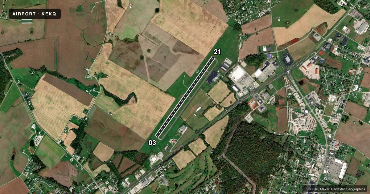
Airport sketch
Runways drawn to scale from FAA survey coordinates, rendered over satellite imagery. Not for navigation.
Approaches & charts
Services on the field
Fuel grades, oxygen, maintenance, ramp storage and lighting — as declared to the FAA by the airport operator.
Fuel & services
- Fuel
- 100LLA+
- Oxygen (bottled)
- Not available
- Oxygen (bulk)
- Not available
- Airframe repair
- Major
- Power plant repair
- Major
- Other services
- AMB,INSTR
Ramp & ground
- Transient storage
- Tie-down
- Hangar
- Landing fee
- No fee published
- Customs
- Not available
- Lighting schedule
- SEE RMK
- Beacon schedule
- SS-SR
- Beacon
- White / Green (civil land)(WG)
- Wind indicator
- Lighted
- Segmented circle
- Yes
Fuel & FBOs
Cheapest 100LL and Jet A on the field and nearby. Always confirm with the FBO before taxi.
Airport notes
Surface conditions, obstructions, local procedures, lighting outages and other notes published with each FAA cycle.
General notes
- FOR CD CTC INDIANAPOLIS ARTCC AT 317-247-2411.
Lighting notes
- ACTVT REIL RWY 21; PAPI RWY 03/21; MIRL RWY 03/21 - CTAF. LTG PRESET LOW INTST; INCR INTST - CTAF.
Fuel notes
- 100LLFUEL AVBL 24/7 WITH CC.
Approach & departure obstructions
- 03FENCE 249.5 FT L PARALLEL TO RWY.
- 03FADED & ALGAE COVERED
- 21FADED & ALGAE COVERED
Other notes
- VFR ONLY.
- MANAGERJERRY CELLPHONE
- OWNERWAYNE CO. JUDGE EXECUTIVE / NANCY ALLEN AIRPORT BOARD SEC. (606-348-4241) LANDLINE
VFR map & nearby airports
VFR sectional. Tap any ICAO chip to open that airport.
Key facts · KEKQ
Answer card- ICAO
- KEKQ
- Name
- WAYNE COUNTY
- Location
- MONTICELLO, KENTUCKY
- Elevation
- 962.6 ft MSL
- Traffic pattern altitude
- 1,962.6 ft MSL (1,000 AGL)
- Control tower
- Non-towered (use CTAF)
- Total runways
- 1
- Longest runway
- 03/21 · 4,000 ft
- Published ILS approaches
- 0
- Published frequencies
- 2
- Magnetic variation
- 3°
- Current flight rules
- LIFR
- Current wind
- 000° at 0 kt
- Favored runway now
- –
Wayne County Airport sits in Monticello, Kentucky. Field elevation is 962.6 ft MSL. The airport has one asphalt runway, 03/21, at 4,000 ft. It is a non-towered field. CTAF and UNICOM are both 122.8. No ILS approaches are published here.
Pattern altitude is not published. Use the standard 1,000 ft AGL for light piston traffic unless the current Chart Supplement says otherwise. The field is VFR only. That matters here because you should plan the arrival with visual conditions in mind and verify the latest airport notes before departure.
Wayne County Airport is on the field. It carries AVGAS 100LL and Jet A. 100LL is available 24 hours a day with a credit card. Published remarks also note faded runway markings on both ends. Runway 21 markings are reported as faded and covered with algae. Runway 03 markings are also faded and covered with algae. There is a fence about 249.5 ft left of runway 03. Runway 03 and runway 21 have PAPI and medium intensity runway lights. Lighting is preset to low intensity and increases on CTAF. If you need clearance delivery, contact Indianapolis ARTCC at 317-247-2411.