METAR & TAF 2A1
2A1 does not publish a METAR.
Showing the nearest reporting station: KSCX (SCOTT MUNI) · 18.6 NM away. Conditions at 2A1 may differ.
METAR · KSCX
Observed 06:15Z
KSCX 270615Z AUTO 15003KT 5SM BR 22/22 A2995 RMK A01
- Wind
- 150° @ 3 kt
- Visibility
- 5 SM
- Temp / Dew
- 22°C / 22°C
- Altimeter
- 29.95 inHg
- Clouds
- Clear
- Density alt
- 2,904 ft
- Ceiling
- Unlimited
- Rules
- MVFR
Airport info & contacts
Manager on record, flight service, ARTCC, attendance schedule and pattern altitude — published by the FAA and refreshed every 28 days.
Location
- From city
- 5 NM S
- VFR sectional
- CINCINNATI
- ARTCC
- ZID · INDIANAPOLIS
- NOTAM facility
- BNA (NOTAM-D)
Airport manager
- Name
- ROB LOWER
- Phone
- 931-260-5871
- Address
- 125 AIRPORT RD, JAMESTOWN TN 38556
Flight service · Hours
- FSS BNA
- NASHVILLE1-800-WX-BRIEF
- Attendance
- MON-SUN · 0800-1600
Frequencies
Tap any row to copy the frequency to your clipboard.
Runways & pattern
Full pagePattern entry · RWY 19
LEFT TRAFFICRunway end performance
| End | TORA | TODA | ASDA | LDA | VGSI | Approach lights | Obstruction |
|---|---|---|---|---|---|---|---|
| 01 | — | — | — | — | PAPI 4-box left(3°) | — | 88', tree, 1528' from thr, 419' R of cntrln, slope 15 |
| 19 | — | — | — | — | PAPI 4-box left(3.55°) | — | 55', tree, 1277' from thr, 170' R of cntrln, slope 19 |
Declared distances in feet. TORA = takeoff run available, TODA = takeoff distance, ASDA = accelerate-stop, LDA = landing distance.
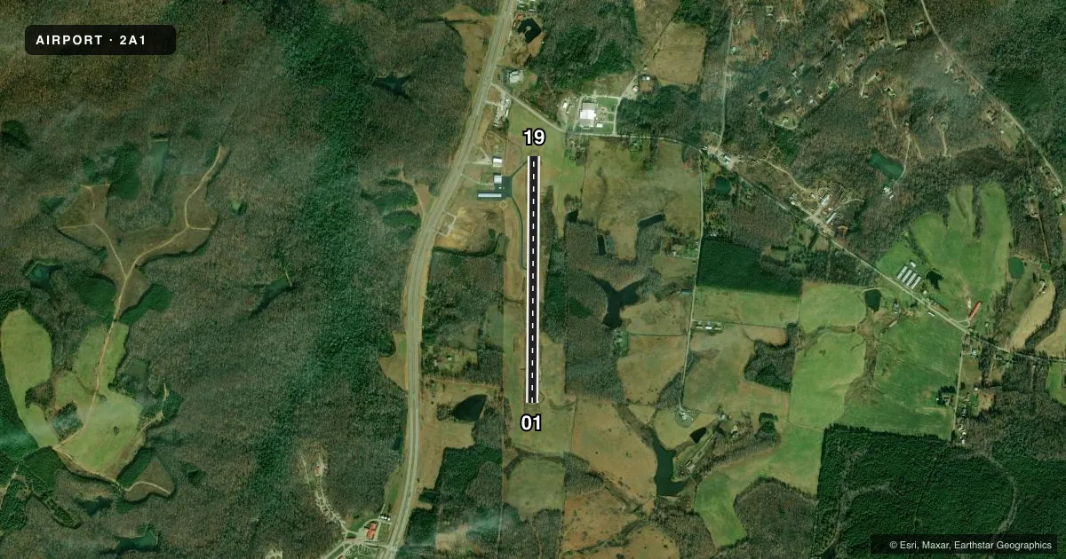
Airport sketch
Runways drawn to scale from FAA survey coordinates, rendered over satellite imagery. Not for navigation.
Approaches & charts
Services on the field
Fuel grades, oxygen, maintenance, ramp storage and lighting — as declared to the FAA by the airport operator.
Fuel & services
- Fuel
- 100LL
- Airframe repair
- Not available
- Power plant repair
- Not available
Ramp & ground
- Transient storage
- Tie-down
- Landing fee
- No fee published
- Customs
- Not available
- Lighting schedule
- SEE RMK
- Beacon schedule
- SS-SR
- Beacon
- White / Green (civil land)(WG)
- Wind indicator
- Lighted
- Segmented circle
- Yes
Fuel & FBOs
Cheapest 100LL and Jet A on the field and nearby. Always confirm with the FBO before taxi.
Airport notes
Surface conditions, obstructions, local procedures, lighting outages and other notes published with each FAA cycle.
General notes
- FOR CD CTC INDIANAPOLIS ARTCC AT 317-247-2411.
Lighting notes
- ACTVT REIL RWY 01 & 19; MIRL 01/19 - CTAF. MIRL 01/19 INCR INTST - CTAF. PAPI RWY 01 & 19 ON CONSLY.
Other notes
- VFR OPS ONLY.
- MANAGERAFT HRS CALL 931-260-5871.
VFR map & nearby airports
VFR sectional. Tap any ICAO chip to open that airport.
Key facts · 2A1
Answer card- ICAO
- 2A1
- Name
- JAMESTOWN MUNI
- Location
- JAMESTOWN, TENNESSEE
- Elevation
- 1,694.3 ft MSL
- Traffic pattern altitude
- 2,694.3 ft MSL (1,000 AGL)
- Control tower
- Non-towered (use CTAF)
- Total runways
- 1
- Longest runway
- 01/19 · 3,498 ft
- Published ILS approaches
- 0
- Published frequencies
- 2
- Magnetic variation
- 5°
- Current flight rules
- MVFR
- Current wind
- 150° at 3 kt
- Favored runway now
- RWY 19
Jamestown Muni sits in Jamestown, Tennessee. The field elevation is 1,694.3 ft MSL. It has one runway, 01/19, at 3,498 ft of concrete. This is a non-towered field. CTAF and UNICOM are both 122.8. No ILS approaches are published here. The airport is VFR only.
Pattern altitude is not published. Use the standard 1,000 ft AGL pattern unless the current FAA Chart Supplement says otherwise. That puts the light piston pattern at about 2,694.3 ft MSL based on the field elevation. Runway lighting is pilot-controlled on 01 and 19. The runway end identifier lights are active too. PAPI is available on both ends. The field has one on-site FBO, Jamestown Municipal Airport. It carries 100LL. For after-hours help, the published manager number is 931-260-5871.
This is a higher-elevation Tennessee strip, so performance planning matters. Check density altitude before departure, especially on warm days. If you need clearance delivery, contact Indianapolis Center at 317-247-2411. For any current noise, lighting, or operating changes, verify the latest FAA Chart Supplement before you go.