METAR & TAF KSCX
Current METAR
Observed 11:35Z
KSCX 271135Z AUTO 00000KT 4SM BR 21/21 A2997 RMK A01
- Wind
- 000° @ 0 kt
- Visibility
- 4 SM
- Temp / Dew
- 21°C / 21°C
- Altimeter
- 29.97 inHg
- Clouds
- Clear
- Density alt
- 2,574 ft
- Ceiling
- Unlimited
- Rules
- MVFR
Airport info & contacts
Manager on record, flight service, ARTCC, attendance schedule and pattern altitude — published by the FAA and refreshed every 28 days.
Location
- From city
- 4 NM SW
- VFR sectional
- CINCINNATI
- ARTCC
- ZID · INDIANAPOLIS
- NOTAM facility
- BNA (NOTAM-D)
Airport manager
- Name
- HANK DUVALL
- Phone
- 423-569-8270
- Address
- 2263 AIRPORT RD, ONEIDA TN 37841
Flight service · Hours
- FSS BNA
- NASHVILLE1-800-WX-BRIEF
- Attendance
- MON-SAT · 0800-1800
- SUN · 1230-1800
Frequencies
Tap any row to copy the frequency to your clipboard.
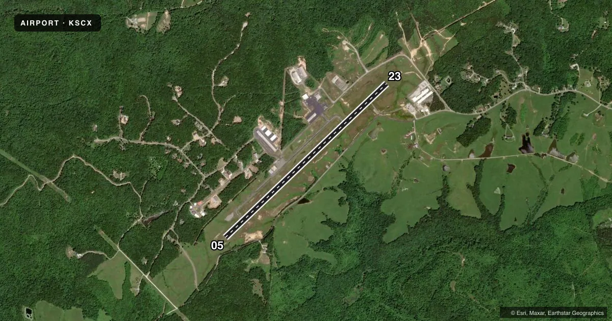
Runways & pattern
Full pagePattern entry · RWY 05
LEFT TRAFFICRunway end performance
| End | TORA | TODA | ASDA | LDA | VGSI | Approach lights | Obstruction |
|---|---|---|---|---|---|---|---|
| 05 | — | — | — | — | PAPI 4-box left(3.5°) | — | 88', trees, 2063' from thr, 486' R of cntrln, slope 21 |
| 23 | — | — | — | — | PAPI 4-box left(3°) | ODALS | 125', trees, 3240' from thr, 703' R of cntrln, slope 24 |
Declared distances in feet. TORA = takeoff run available, TODA = takeoff distance, ASDA = accelerate-stop, LDA = landing distance.
Airport sketch
Runways drawn to scale from FAA survey coordinates, rendered over satellite imagery. Not for navigation.
Approaches & charts
Services on the field
Fuel grades, oxygen, maintenance, ramp storage and lighting — as declared to the FAA by the airport operator.
Fuel & services
- Fuel
- 100LLA+
- Oxygen (bottled)
- Low pressure
- Oxygen (bulk)
- High pressure
- Airframe repair
- Major
- Power plant repair
- Major
Ramp & ground
- Transient storage
- Tie-down
- Hangar
- Landing fee
- No fee published
- Customs
- Not available
- Lighting schedule
- SEE RMK
- Beacon schedule
- SS-SR
- Beacon
- White / Green (civil land)(WG)
- Wind indicator
- Lighted
- Segmented circle
- Yes
Fuel & FBOs
Cheapest 100LL and Jet A on the field and nearby. Always confirm with the FBO before taxi.
Airport notes
Surface conditions, obstructions, local procedures, lighting outages and other notes published with each FAA cycle.
General notes
- WILDLIFE ON & INVOF ARPT.
- FOR CD CTC INDIANAPOLIS ARTCC AT 317-247-2411.
Lighting notes
- ACTVT ODALS RWY 23; REIL RWY 5 & 23; MIRL RWY 05/23 - CTAF. MIRL RWY 05/23 PRESET LOW INTST; INCR INTST - CTAF. PAPI RWY 05 & 23 OPR CONSLY.
Fuel notes
- 100LLFUEL 24 HR CREDIT CARD SVC AVBL.
Other notes
- 1UNATNDD THANKSGIVING & CHRISTMAS.
- 1AFT HR - 423-223-4331.
VFR map & nearby airports
VFR sectional. Tap any ICAO chip to open that airport.
Key facts · KSCX
Answer card- ICAO
- KSCX
- Name
- SCOTT MUNI
- Location
- ONEIDA, TENNESSEE
- Elevation
- 1,544.8 ft MSL
- Traffic pattern altitude
- 2,544.8 ft MSL (1,000 AGL)
- Control tower
- Non-towered (use CTAF)
- Total runways
- 1
- Longest runway
- 05/23 · 5,505 ft
- Published ILS approaches
- 0
- Published frequencies
- 2
- Magnetic variation
- 5°
- Current flight rules
- MVFR
- Current wind
- 000° at 0 kt
- Favored runway now
- –
Scott Muni sits in Oneida, Tennessee. The field elevation is 1,544.8 ft MSL. It has one runway. Runway 05/23 is 5,505 ft long with an asphalt surface. The airport is non-towered. CTAF and UNICOM are both 122.8. No ILS approaches are published here.
Pattern altitude is not published. Use the standard 1,000 ft AGL pattern for light piston aircraft unless the current Chart Supplement or local procedures say otherwise. Runway lighting is pilot-controlled on CTAF. Runway 23 has ODALs. Runway end identifier lights are installed on both ends. PAPI operates continuously on runways 05 and 23. Fuel is available 24 hours with credit card service. The on-field FBO is Scott County Airport. It carries 100LL and Jet A Prist. Call ahead at (423) 569-8270 if you need current service details. The airport is unattended on Thanksgiving and Christmas.
This is a high-elevation field, so performance planning matters. Wildlife is also reported on and near the airport. If you are filing IFR, clearance delivery is handled through Indianapolis ARTCC at 317-247-2411. Check the current FAA Chart Supplement before departure for any updates, then verify local conditions with the airport operator if needed.