METAR & TAF KBYL
Current METAR
Observed 16:35Z
KBYL 261635Z AUTO 02003KT 10SM SCT023 BKN031 27/22 A3002 RMK AO2 T02670219
- Wind
- 020° @ 3 kt
- Visibility
- 10 SM
- Temp / Dew
- 27°C / 22°C
- Altimeter
- 30.02 inHg
- Clouds
- BKN
- Density alt
- 2,776 ft
- Ceiling
- 3,100 ft AGL
- Rules
- VFR
Airport info & contacts
Manager on record, flight service, ARTCC, attendance schedule and pattern altitude — published by the FAA and refreshed every 28 days.
Location
- From city
- 4 NM NNW
- VFR sectional
- CINCINNATI
- ARTCC
- ZID · INDIANAPOLIS
- NOTAM facility
- LOU (NOTAM-D)
Airport manager
- Name
- DON STRICKLIN
- Phone
- 606-549-2688
- Address
- 1000 AVIATION BOULEVARD, WILLIAMSBURG KY 40769
Flight service · Hours
- FSS LOU
- LOUISVILLE1-800-WX-BRIEF
- Attendance
- MON-SAT · 0900-1800
- SUN · 1200-1600
Frequencies
Tap any row to copy the frequency to your clipboard.
Runways & pattern
Full pagePattern entry · RWY 02
LEFT TRAFFICRunway end performance
| End | TORA | TODA | ASDA | LDA | VGSI | Approach lights | Obstruction |
|---|---|---|---|---|---|---|---|
| 02 | — | — | — | — | PAPI 4-box left(3.17°) | — | — |
| 20 | — | — | — | — | PAPI 4-box left(3.17°) | — | 15', trees, 252' from thr, 244' R of cntrln, slope 3 |
Declared distances in feet. TORA = takeoff run available, TODA = takeoff distance, ASDA = accelerate-stop, LDA = landing distance.
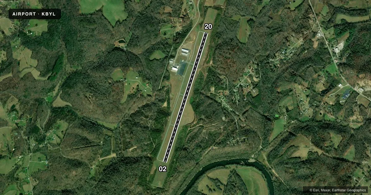
Airport sketch
Runways drawn to scale from FAA survey coordinates, rendered over satellite imagery. Not for navigation.
Approaches & charts
ILS · 1
Services on the field
Fuel grades, oxygen, maintenance, ramp storage and lighting — as declared to the FAA by the airport operator.
Fuel & services
- Fuel
- 100LLA+
- Other services
- CARGO,INSTR
Ramp & ground
- Transient storage
- Tie-down
- Hangar
- Lighting schedule
- SEE RMK
- Beacon schedule
- SS-SR
- Beacon
- White / Green (civil land)(WG)
- Wind indicator
- Lighted
- Segmented circle
- Yes
Fuel & FBOs
Cheapest 100LL and Jet A on the field and nearby. Always confirm with the FBO before taxi.
Airport notes
Surface conditions, obstructions, local procedures, lighting outages and other notes published with each FAA cycle.
General notes
- COLD TEMPERATURE AIRPORT. ALTITUDE CORRECTION REQUIRED AT OR BELOW -16C.
- FOR CD CTC INDIANAPOLIS ARTCC AT 317-247-2411.
Lighting notes
- ACTVT REIL RWY 02/20; PAPI RWY 02/20; MIRL RWY 02/20 - CTAF.
Approach & departure obstructions
- 02FADED & ALGAE COVERED.
- 20FADED & ALGAE COVERED.
Other notes
- 1TRML 24/7.
- MANAGERHARVEY ALDER
VFR map & nearby airports
VFR sectional. Tap any ICAO chip to open that airport.
Key facts · KBYL
Answer card- ICAO
- KBYL
- Name
- WILLIAMSBURG-WHITLEY COUNTY
- Location
- WILLIAMSBURG, KENTUCKY
- Elevation
- 1,177.7 ft MSL
- Traffic pattern altitude
- 2,177.7 ft MSL (1,000 AGL)
- Control tower
- Non-towered (use CTAF)
- Total runways
- 1
- Longest runway
- 02/20 · 5,499 ft
- Published ILS approaches
- 1
- Published frequencies
- 2
- Magnetic variation
- 5°
- Current flight rules
- VFR
- Current wind
- 020° at 3 kt
- Favored runway now
- RWY 02
Williamsburg-Whitley County Airport is in Williamsburg, Kentucky. The field elevation is 1,177.7 ft MSL. It has one runway, 02/20, which is 5,499 ft long. There is no control tower. CTAF and UNICOM are both 122.7. The airport has one ILS approach. It serves runway 20.
Pattern altitude is not published. Use the standard 1,000 ft AGL for light piston operations unless the current Chart Supplement says otherwise. This field sits in a higher-elevation part of Kentucky, so take density altitude into account on warm days. The published remarks also note cold temperature corrections at or below minus 16 degrees Celsius. Runway end identifier lights are active on 02/20. Medium intensity runway lights are installed on 02/20 and are controlled by CTAF. Precision approach path indicators are installed on the runway.
The on-field FBO is Williamsburg-Whitley County Airport. It carries AVGAS 100LL and Jet A Prist. The terminal is open 24 hours a day. Published remarks also say runway markings on both ends are faded and covered with algae. For clearance delivery, contact Indianapolis ARTCC at 317-247-2411. If you are planning a first visit, verify current runway condition and lighting use with the airport operator or the FBO directly by phone before arrival.