METAR & TAF 0VG
Current METAR
Observed 12:55Z
K0VG 271255Z AUTO 9SM SCT003 OVC020 22/22 A2998 RMK AO2
- Wind
- Calm
- Visibility
- 9 SM
- Temp / Dew
- 22°C / 22°C
- Altimeter
- 29.98 inHg
- Clouds
- OVC
- Density alt
- 2,515 ft
- Ceiling
- 2,000 ft AGL
- Rules
- MVFR
Airport info & contacts
Manager on record, flight service, ARTCC, attendance schedule and pattern altitude — published by the FAA and refreshed every 28 days.
Location
- From city
- 5 NM SW
- VFR sectional
- CINCINNATI
- ARTCC
- ZTL · ATLANTA
- NOTAM facility
- DCA (NOTAM-D)
Airport manager
- Name
- CLINT CARTER
- Phone
- 276-346-7714
- Address
- 33640 MAIN ST, JONESVILLE VA 24263
Flight service · Hours
- FSS DCA
- LEESBURG1-800-WX-BRIEF
- Attendance
- Unattended
Frequencies
Tap any row to copy the frequency to your clipboard.
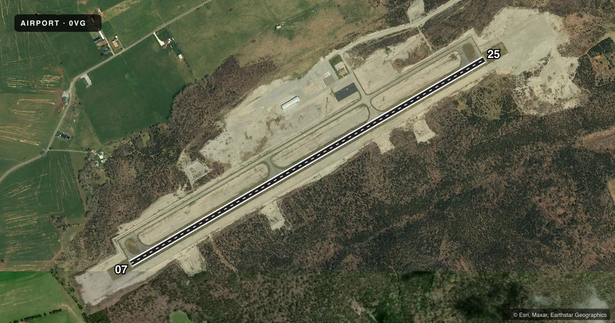
Runways & pattern
Full pagePattern entry · RWY 07
LEFT TRAFFICRunway end performance
| End | TORA | TODA | ASDA | LDA | VGSI | Approach lights | Obstruction |
|---|---|---|---|---|---|---|---|
| 07 | — | — | — | — | PAPI 4-box left(3°) | — | 67', tree, 2367' from thr, 477' R of cntrln, slope 32 |
| 25 | — | — | — | — | PAPI 4-box right(3.25°) | — | 15', tree, 495' from thr, 201' R of cntrln, slope 19 |
Declared distances in feet. TORA = takeoff run available, TODA = takeoff distance, ASDA = accelerate-stop, LDA = landing distance.
Airport sketch
Runways drawn to scale from FAA survey coordinates, rendered over satellite imagery. Not for navigation.
Approaches & charts
Services on the field
Fuel grades, oxygen, maintenance, ramp storage and lighting — as declared to the FAA by the airport operator.
Fuel & services
- Fuel
- 100LLA+
Ramp & ground
- Transient storage
- Tie-down
- Lighting schedule
- SEE RMK
- Beacon schedule
- SS-SR
- Beacon
- White / Green (civil land)(WG)
- Wind indicator
- Lighted
- Segmented circle
- Yes
Fuel & FBOs
Cheapest 100LL and Jet A on the field and nearby. Always confirm with the FBO before taxi.
Airport notes
Surface conditions, obstructions, local procedures, lighting outages and other notes published with each FAA cycle.
General notes
- FOR CD CTC ATLANTA ARTCC AT 770-210-7692.
Lighting notes
- ACTVT REIL RWY 07 & 25; PAPI RWY 07 & 25; MIRL RWY 07/25 - CTAF.
Approach & departure obstructions
- 073 FT TREE 108 FT FRM THLD, 198 FT L OF CNTRLN ON APCH.
Other notes
- MANAGERCOUNTY ADMINISTRATOR.
VFR map & nearby airports
VFR sectional. Tap any ICAO chip to open that airport.
Key facts · 0VG
Answer card- ICAO
- 0VG
- Name
- LEE COUNTY
- Location
- JONESVILLE, VIRGINIA
- Elevation
- 1,410.9 ft MSL
- Traffic pattern altitude
- 2,410.9 ft MSL (1,000 AGL)
- Control tower
- Non-towered (use CTAF)
- Total runways
- 1
- Longest runway
- 07/25 · 5,003 ft
- Published ILS approaches
- 0
- Published frequencies
- 1
- Magnetic variation
- 6°
- Current flight rules
- MVFR
- Current wind
- Calm / unavailable
- Favored runway now
- –
Lee County Airport (0VG) sits in Jonesville, Virginia. Field elevation is 1,410.9 ft MSL. The airport has one runway. Runway 07/25 is 5,003 ft long with asphalt pavement. There is no control tower, so use CTAF 122.9 for local traffic calls.
No ILS approaches are published here. Runway 07 and 25 both have runway end identifier lights. Precision approach path indicators are installed on both ends. Medium intensity runway lights are installed on runway 07/25. The published pattern altitude is not listed, so use standard 1,000 ft AGL unless the current FAA Chart Supplement says otherwise. That puts the light piston pattern at about 2,411 ft MSL based on the field elevation.
On-field fuel is available from Lee County Airport. They carry AVGAS 100LL and JET A. Call (276) 346-7714 before arrival for current services. One published obstacle note matters on short final to runway 07. There is a 3-foot tree 108 ft from the threshold and 198 ft left of centerline. Clearance delivery is handled through Atlanta ARTCC at 770-210-7692. This is a non-towered field in terrain that deserves a normal mountain-country scan for performance, winds and density altitude.