METAR & TAF KLNP
Current METAR
Observed 09:55Z
KLNP 270955Z AUTO 27004KT 3/4SM BR BKN003 18/18 A3000 RMK AO2
- Wind
- 270° @ 4 kt
- Visibility
- 0.75 SM
- Temp / Dew
- 18°C / 18°C
- Altimeter
- 30.00 inHg
- Clouds
- BKN
- Density alt
- 3,590 ft
- Ceiling
- 300 ft AGL
- Rules
- LIFR
Airport info & contacts
Manager on record, flight service, ARTCC, attendance schedule and pattern altitude — published by the FAA and refreshed every 28 days.
Location
- From city
- 3 NM NE
- VFR sectional
- CINCINNATI
- ARTCC
- ZID · INDIANAPOLIS
- NOTAM facility
- LNP (NOTAM-D)
Airport manager
- Name
- JOSEPH TEAGUE
- Phone
- 276-328-5300
- Address
- 6225 AIRPORT RD., WISE VA 24293
Flight service · Hours
- FSS DCA
- LEESBURG1-800-WX-BRIEF
- Attendance
- MON-SAT · 0900-1800
Frequencies
Tap any row to copy the frequency to your clipboard.
Runways & pattern
Full pagePattern entry · RWY 24
LEFT TRAFFICRunway end performance
| End | TORA | TODA | ASDA | LDA | VGSI | Approach lights | Obstruction |
|---|---|---|---|---|---|---|---|
| 06 | — | — | — | — | PAPI 4-box left(3°) | — | 54', trees, 1185' from thr, 240' R of cntrln, slope 18 |
| 24 | — | — | — | — | PAPI 4-box right(3°) | ODALS | 38', tree, 926' from thr, 350' R of cntrln, slope 19 |
Declared distances in feet. TORA = takeoff run available, TODA = takeoff distance, ASDA = accelerate-stop, LDA = landing distance.
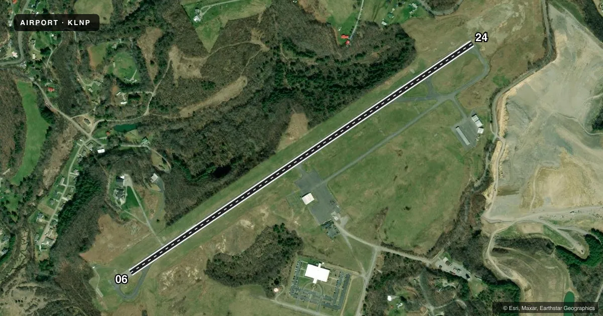
Airport sketch
Runways drawn to scale from FAA survey coordinates, rendered over satellite imagery. Not for navigation.
Approaches & charts
ILS · 1
Services on the field
Fuel grades, oxygen, maintenance, ramp storage and lighting — as declared to the FAA by the airport operator.
Fuel & services
- Fuel
- 100LLA+
- Oxygen (bottled)
- Not available
- Oxygen (bulk)
- Not available
- Other services
- INSTR,RNTL,SURV
Ramp & ground
- Transient storage
- Tie-down
- Hangar
- Landing fee
- No fee published
- Customs
- Not available
- Lighting schedule
- SEE RMK
- Beacon schedule
- SS-SR
- Beacon
- White / Green (civil land)(WG)
- Wind indicator
- Lighted
- Segmented circle
- Yes
Fuel & FBOs
Cheapest 100LL and Jet A on the field and nearby. Always confirm with the FBO before taxi.
Airport notes
Surface conditions, obstructions, local procedures, lighting outages and other notes published with each FAA cycle.
General notes
- WILDLIFE ON/INVOF AIRPORT.
- UNATTENDED SUNDAY.
- FOR CD CTC INDIANAPOLIS ARTCC AT 317-247-2411.
Lighting notes
- ACTVT ODALS RWY 24; REIL RWY 06; MIRL 06/24 - CTAF.
Approach & departure obstructions
- 24NSTD ODALS; 3 LGT CONFIGN.
Other notes
- OWNERDONNIE ROSE, CHAIRMAN.
- MANAGERAFT HRS CTC 276-455-4481 OR 276-219-9807.
VFR map & nearby airports
VFR sectional. Tap any ICAO chip to open that airport.
Key facts · KLNP
Answer card- ICAO
- KLNP
- Name
- LONESOME PINE
- Location
- WISE, VIRGINIA
- Elevation
- 2,684.8 ft MSL
- Traffic pattern altitude
- 3,684.8 ft MSL (1,000 AGL)
- Control tower
- Non-towered (use CTAF)
- Total runways
- 1
- Longest runway
- 06/24 · 5,131 ft
- Published ILS approaches
- 1
- Published frequencies
- 2
- Magnetic variation
- 6°
- Current flight rules
- LIFR
- Current wind
- 270° at 4 kt
- Favored runway now
- RWY 24
Lonesome Pine Airport sits in Wise, Virginia at 2,684.8 ft MSL. It has one runway, 06/24 and the longest runway is 5,131 ft of asphalt. The field is unattended on Sunday. There is no control tower. CTAF and UNICOM are both 123.0. Clearance delivery is handled through Indianapolis ARTCC at 317-247-2411 when needed.
The published pattern altitude is not listed, so use the standard 1,000 ft AGL unless the current Chart Supplement says otherwise. That puts the light-piston pattern at 3,684.8 ft MSL based on the field elevation. Runway 24 has an ILS approach. Runway 24 also has a nonstandard omnidirectional approach lighting system with a three-light configuration. Runway 06 has runway end identifier lights. Medium intensity runway lights are on both ends. They are controlled by the CTAF.
Cumberland Airport Commission is the on-field FBO. It carries 100LL and Jet A. Call the field directly at (276) 328-5300 for current service details. Wildlife is present on and near the airport, so plan your taxi and departure with that in mind. This is a higher-elevation field in southwest Virginia, so performance planning matters, especially on warm days.