METAR & TAF KTRI
Current METAR
Observed 12:53Z
KTRI 271253Z 27004KT 2 1/2SM BR SCT006 OVC019 22/22 A2998 RMK AO2 SFC VIS 6 SLP125 T02220217 $
- Wind
- 270° @ 4 kt
- Visibility
- 0.5 SM
- Temp / Dew
- 22°C / 22°C
- Altimeter
- 29.98 inHg
- Clouds
- OVC
- Density alt
- 2,649 ft
- Ceiling
- 1,900 ft AGL
- Rules
- LIFR
Airport info & contacts
Manager on record, flight service, ARTCC, attendance schedule and pattern altitude — published by the FAA and refreshed every 28 days.
Location
- From city
- 12 NM SW
- VFR sectional
- CINCINNATI
- ARTCC
- ZTL · ATLANTA
- NOTAM facility
- TRI (NOTAM-D)
Airport manager
- Name
- GENE COSSEY
- Phone
- (423) 325-6001
- Address
- 2525 HWY 75, SUITE 301, BLOUNTVILLE TN 37617
Flight service · Hours
- FSS BNA
- NASHVILLE1-800-WX-BRIEF
- Attendance
- ALL
Frequencies
Tap any row to copy the frequency to your clipboard.
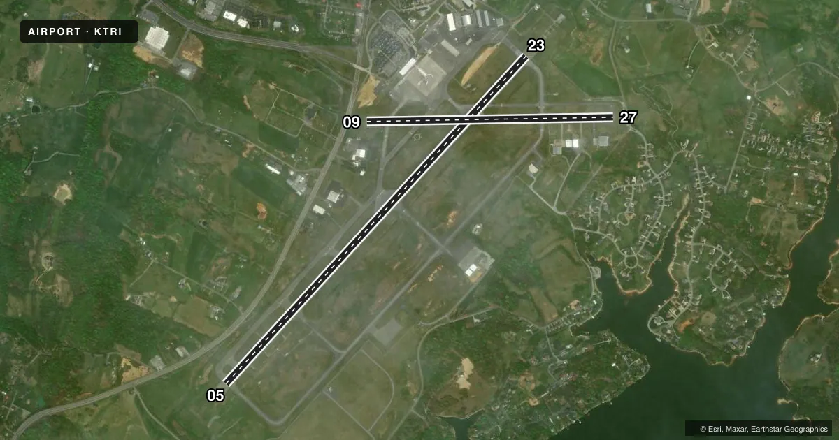
Runways & pattern
Full pagePattern entry · RWY 27
LEFT TRAFFIC| Runway | Heading (°M) | Length | Surface | Traffic |
|---|---|---|---|---|
| 05/23 | 36° / 216° | 8,000 ft | ASPH | Standard L |
| 09/27Favored | 82° / 262° | 4,443 ft | ASPH | Standard L |
Runway end performance
| End | TORA | TODA | ASDA | LDA | VGSI | Approach lights | Obstruction |
|---|---|---|---|---|---|---|---|
| 05 | 8,000' | 8,000' | 8,000' | 8,000' | PAPI 4-box left(3°) | — | 142', trees, 5040' from thr, 1037' R of cntrln, slope 34 |
| 23 | 8,000' | 8,000' | 8,000' | 8,000' | PAPI 4-box right(3°) | ALSF2 | 47', trees, 1900' from thr, 650' R of cntrln, slope 40 |
| 09 | 4,443' | 4,443' | 4,321' | 4,321' | — | — | — |
| 27 | 4,443' | 4,443' | 4,184' | 4,057' | PAPI 4-box left(3°) | — | — |
Declared distances in feet. TORA = takeoff run available, TODA = takeoff distance, ASDA = accelerate-stop, LDA = landing distance.
Airport sketch
Runways drawn to scale from FAA survey coordinates, rendered over satellite imagery. Not for navigation.
Approaches & charts
ILS · 2
Services on the field
Fuel grades, oxygen, maintenance, ramp storage and lighting — as declared to the FAA by the airport operator.
Fuel & services
- Fuel
- 100LLA
- Oxygen (bottled)
- Not available
- Oxygen (bulk)
- HIGH/LOW
- Airframe repair
- Major
- Power plant repair
- Major
- Other services
- AFRT,AVNCS,CARGO,CHTR,INSTR,RNTL
Ramp & ground
- Transient storage
- Tie-down
- Hangar
- Landing fee
- No fee published
- Customs
- Not available
- Lighting schedule
- SS-SR
- Beacon schedule
- SS-SR
- Beacon
- White / Green (civil land)(WG)
- Wind indicator
- Lighted
- Segmented circle
- Yes
Fuel & FBOs
Cheapest 100LL and Jet A on the field and nearby. Always confirm with the FBO before taxi.
Airport notes
Surface conditions, obstructions, local procedures, lighting outages and other notes published with each FAA cycle.
General notes
- FOR CD IF UNA TO CTC ON FSS FREQ, CTC ATLANTA ARTCC AT 770-210-7692.
- RWY 09/27 UNAVBL WHEN TWR CLOSED.
- ACFT WITH WINGSPAN MORE THAN 79 FT ARE RSTRD FROM USING TWY A BTN TWY Y AND APCH END RWY 05 WHEN ACFT WITH WINGSPAN MORE THAN 79 FT USING RWY 05/23.
- BIRDS ON & INVOF THE APRT.
Runway surface & condition
- 05/23PCR VALUE: 560/F/B/X/T
- 09/27PCR VALUE: 380/F/C/X/T
Other notes
- US CUSTOMS USER FEE ARPT.
- OWNERCITIES OF BRISTOL, TN; BRISTOL, VA; JOHNSON CITY & KINGSPORT, TN; COUNTIES OF WASHINGTON & SULLIVAN. TRI CITIES AIRPORT AUTHORITY SETS POLICY AND HAS FINANCIAL AUTHORITY FOR THE AIRPORT.
VFR map & nearby airports
VFR sectional. Tap any ICAO chip to open that airport.
Key facts · KTRI
Answer card- ICAO
- KTRI
- Name
- TRI-CITIES
- Location
- BRISTOL/JOHNSON/KINGSPORT, TENNESSEE
- Elevation
- 1,518.6 ft MSL
- Traffic pattern altitude
- 2,518.6 ft MSL (1,000 AGL)
- Control tower
- Towered · 0600-0000
- Total runways
- 2
- Longest runway
- 05/23 · 8,000 ft
- Published ILS approaches
- 2
- Published frequencies
- 18
- Magnetic variation
- 7°
- Current flight rules
- LIFR
- Current wind
- 270° at 4 kt
- Favored runway now
- RWY 27
Tri-Cities Airport sits in Bristol, Johnson City and Kingsport, Tennessee. Field elevation is 1,518.6 ft MSL. The airport has two asphalt runways. The longest is 05/23 at 8,000 ft. Runway 09/27 is 4,443 ft. The tower is open from 0600 to 0000. Two ILS approaches are published for runway ends 05 and 23.
Pattern altitude is not published in the facts. Use 1,000 ft AGL for light piston traffic unless the current Chart Supplement says otherwise. That puts the common pattern reference near 2,519 ft MSL. Tri-Cities is a U.S. Customs user fee airport. Birds are reported on and in the vicinity of the airport, so keep a sharp scan on departure and arrival. Runway 09/27 is unavailable when the tower is closed.
Tri-City Aviation is on the field. It carries 100LL and Jet A with Prist support. For clearance delivery, if you cannot reach Flight Service on the published frequency, contact Atlanta ARTCC at 770-210-7692. Large aircraft crews should note the published taxiway restriction near runway 05. Check the current FAA Chart Supplement for any noise or operating notes before you go.