METAR & TAF 7A8
7A8 does not publish a METAR.
Showing the nearest reporting station: KMRN (FOOTHILLS RGNL) · 20.2 NM away. Conditions at 7A8 may differ.
METAR · KMRN
Observed 12:35Z
KMRN 271235Z AUTO 00000KT 10SM SCT002 22/22 A2994 RMK AO2 T02240221
- Wind
- 000° @ 0 kt
- Visibility
- 10 SM
- Temp / Dew
- 22°C / 22°C
- Altimeter
- 29.94 inHg
- Clouds
- SCT
- Density alt
- 4,219 ft
- Ceiling
- Unlimited
- Rules
- VFR
Airport info & contacts
Manager on record, flight service, ARTCC, attendance schedule and pattern altitude — published by the FAA and refreshed every 28 days.
Location
- From city
- 4 NM NE
- VFR sectional
- ATLANTA
- ARTCC
- ZTL · ATLANTA
- NOTAM facility
- RDU (NOTAM-D)
Airport manager
- Name
- DEAN HARRIS
- Phone
- 828-260-3668
- Address
- 400 BRUSHY CREEK ROAD, SPRUCE PINE NC 28777
Flight service · Hours
- FSS RDU
- RALEIGH1-800-WX-BRIEF
- Attendance
- UNATTENDED
Frequencies
Tap any row to copy the frequency to your clipboard.
Runways & pattern
Full pagePattern entry · RWY 17
RIGHT TRAFFICRunway end performance
| End | TORA | TODA | ASDA | LDA | VGSI | Approach lights | Obstruction |
|---|---|---|---|---|---|---|---|
| 17 | — | — | — | — | — | — | 11', brush, 206' from thr, 50' R of cntrln, slope 0 |
| 35 | — | — | — | — | — | — | 59', trees, 1098' from thr, 205' R of cntrln, slope 15 |
Declared distances in feet. TORA = takeoff run available, TODA = takeoff distance, ASDA = accelerate-stop, LDA = landing distance.
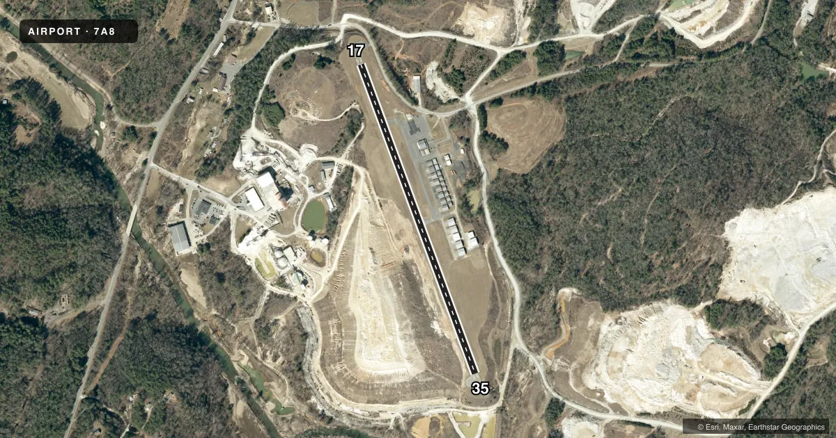
Airport sketch
Runways drawn to scale from FAA survey coordinates, rendered over satellite imagery. Not for navigation.
Approaches & charts
Services on the field
Fuel grades, oxygen, maintenance, ramp storage and lighting — as declared to the FAA by the airport operator.
Fuel & services
- Fuel
- 100LLA1+
- Oxygen (bottled)
- Not available
- Oxygen (bulk)
- Not available
- Airframe repair
- Not available
- Power plant repair
- Not available
- Other services
- AMB
Ramp & ground
- Transient storage
- Tie-down
- Landing fee
- No fee published
- Customs
- Not available
- Wind indicator
- Yes
- Segmented circle
- No
Fuel & FBOs
Cheapest 100LL and Jet A on the field and nearby. Always confirm with the FBO before taxi.
Airport notes
Surface conditions, obstructions, local procedures, lighting outages and other notes published with each FAA cycle.
General notes
- VFR OPS ONLY.
- RWY 35 MTUS TRRN 6000 FT FM RWY END AND 650 FT ABV RWY ELEV ON CNTRLN.
- RWY 35 HAS 60 FT DROP-OFF 250 FT FROM THR AND 50 RIGHT OF CNTRLN. RWY 17 HAS 40 FT DROP-OFF 300 FT FROM THR.
- HIGH TRRN ALL QUADS, DALGT VFR OPS ONLY, RWY 35 UPHILL GRADE, RWY 17 RGT TFC PREF FOR TKOF.
- MIL OPS ON AND INVOF ARPT.
- WILDLIFE ON AND INVOF ARPT.
- GRAVEL MINING OPS WEST OF AND ADJ TO RWY WITH DIRT BANK RANGING 26-48 FT HIGH LCTD 300-500 FT FROM RWY CNTRLN.
- RWY 35 HAS 220+ FT TREES AND MTUS TRRN 2200FT FM THLD OFFSET 400 FT RIGHT OF CNTRLN.
- FOR CD CTC ATLANTA ARTCC AT 770-210-7692.
- ONGOING CONST ACT WITH MEN AND EQUIP ON AND INVOF RWY 17/35.
- GRASS LDG AREA FOR JAARS TRNG ONLY; SIMUL LDGS ON GRASS AND ON RWY PROHIBITED.
Fuel notes
- 100LL24 HR 100LL & JET A FUEL SVC AVBL WITH CREDIT CARD.
Runway surface & condition
- 17/35RWY 17/35 RWY 17 PREF FOR TKOFS - RWY 35 PREF FOR LDGS.
Approach & departure obstructions
- 17HAS 9 FT TREES 0-100 FT FR THR OFFSET 120 FT LEFT OF CNTRLN. AND 14 FT TREES 197 FT FR THR OFFSET 97 FT RIGHT OF CNTRLN
- 17CTLNG OBSTN EXCEEDS A 45 DEG SLP.
Other notes
- AUTOMATED UNICOM.
VFR map & nearby airports
VFR sectional. Tap any ICAO chip to open that airport.
Key facts · 7A8
Answer card- ICAO
- 7A8
- Name
- AVERY COUNTY/MORRISON FLD
- Location
- SPRUCE PINE, NORTH CAROLINA
- Elevation
- 2,745.2 ft MSL
- Traffic pattern altitude
- 3,745.2 ft MSL (1,000 AGL)
- Control tower
- Non-towered (use CTAF)
- Total runways
- 1
- Longest runway
- 17/35 · 3,001 ft
- Published ILS approaches
- 0
- Published frequencies
- 2
- Magnetic variation
- 6°
- Current flight rules
- VFR
- Current wind
- 000° at 0 kt
- Favored runway now
- –
Avery County/Morrison Fld (7A8) sits in Spruce Pine, North Carolina. Field elevation is 2,745.2 ft MSL. The airport has one runway. Runway 17/35 is 3,001 ft long and paved with asphalt. There is no control tower. CTAF and UNICOM are both 123.0, with automated UNICOM published. No ILS approaches are published here.
The field is VFR only. Pattern altitude is not published. Use the standard 1,000 ft AGL pattern for light piston operations unless the current Chart Supplement or local procedures say otherwise. On-field fuel is available from Avery County Airport. It carries 100LL and Jet A Prist. Twenty-four hour fuel service is published with credit card access.
This is a mountain airport. High terrain surrounds the field in all quadrants. Runway 35 has trees and mountainous terrain near the threshold. It also has an uphill grade. Runway 35 is preferred for landings. Runway 17 is preferred for takeoffs. Runway 17 right traffic is preferred for takeoff. There is ongoing construction activity on and near the runway. Wildlife and military operations are also published concerns. Grass use is for JAARS training only. Simulated landings on the grass and on the runway are prohibited. Check the current Chart Supplement before departure for any changes or local restrictions.