METAR & TAF KMRN
Current METAR
Observed 12:35Z
KMRN 271235Z AUTO 00000KT 10SM SCT002 22/22 A2994 RMK AO2 T02240221
- Wind
- 000° @ 0 kt
- Visibility
- 10 SM
- Temp / Dew
- 22°C / 22°C
- Altimeter
- 29.94 inHg
- Clouds
- SCT
- Density alt
- 2,390 ft
- Ceiling
- Unlimited
- Rules
- VFR
Airport info & contacts
Manager on record, flight service, ARTCC, attendance schedule and pattern altitude — published by the FAA and refreshed every 28 days.
Location
- From city
- 6 NM NE
- VFR sectional
- CHARLOTTE
- ARTCC
- ZTL · ATLANTA
- NOTAM facility
- MRN (NOTAM-D)
Airport manager
- Name
- BRENT BRINKLEY
- Phone
- 828-757-0099
- Address
- 3566 FOOTHILLS AIRPORT RD, MORGANTON NC 28655
Flight service · Hours
- FSS RDU
- RALEIGH1-800-WX-BRIEF
- Attendance
- MON-SAT · 0800-1700
- SUN · 0900-1700
Frequencies
Tap any row to copy the frequency to your clipboard.
Runways & pattern
Full pagePattern entry · RWY 03
LEFT TRAFFICRunway end performance
| End | TORA | TODA | ASDA | LDA | VGSI | Approach lights | Obstruction |
|---|---|---|---|---|---|---|---|
| 03 | — | — | — | — | PAPI 4-box left(3°) | — | 19', trees, 729' from thr, 210' R of cntrln, slope 27 |
| 21 | — | — | — | — | PAPI 4-box right(3.5°) | — | 26', trees, 458' from thr, 243' R of cntrln, slope 9 |
Declared distances in feet. TORA = takeoff run available, TODA = takeoff distance, ASDA = accelerate-stop, LDA = landing distance.
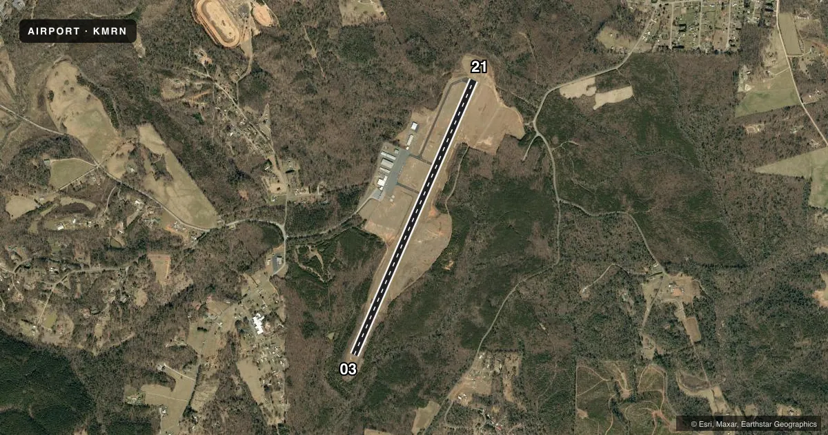
Airport sketch
Runways drawn to scale from FAA survey coordinates, rendered over satellite imagery. Not for navigation.
Approaches & charts
ILS · 1
Services on the field
Fuel grades, oxygen, maintenance, ramp storage and lighting — as declared to the FAA by the airport operator.
Fuel & services
- Fuel
- 100LLA1+
- Oxygen (bottled)
- Low pressure
- Oxygen (bulk)
- High pressure
- Airframe repair
- Major
- Power plant repair
- Major
- Other services
- AFRT,CARGO,GLD,INSTR,RNTL,SALES,TOW
Ramp & ground
- Transient storage
- Tie-down
- Landing fee
- No fee published
- Customs
- Not available
- Lighting schedule
- SEE RMK
- Beacon schedule
- SS-SR
- Beacon
- White / Green (civil land)(WG)
- Wind indicator
- Lighted
- Segmented circle
- Yes
Fuel & FBOs
Cheapest 100LL and Jet A on the field and nearby. Always confirm with the FBO before taxi.
Airport notes
Surface conditions, obstructions, local procedures, lighting outages and other notes published with each FAA cycle.
General notes
- RY 03, 100 FT DROPOFF 330 FT FM THLD AND 80 FT BOTH SIDES OF CNTRLN ALONG FIRST 1000 FT OF RY.
- RY 21, 30 FT DROPOFF 400 FT FM THLD BOTH SIDES AND 10 FT DROPOFF 50 FT FM THLD AND 150 FT RIGHT OF CNTRLN.
- HANG GLIDER ACT DALGT HRS - EAST SIDE OF RWY 03/21 IN RWY SAFETY AREA.
- DEER & COYOTE ON & INVOF ARPT.
- FOR CD CTC ATLANTA ARTCC AT 770-210-7692.
- APRON TIE DOWN SPACE LTD.
Lighting notes
- ACTVT REILS RWY 03 & 21; PAPI RWY 03 & 21; MIRL RWY 03/21 - CTAF.
Fuel notes
- 100LLAFTER HOURS FUEL OR SERVICE CALL 828-757-0099
VFR map & nearby airports
VFR sectional. Tap any ICAO chip to open that airport.
Key facts · KMRN
Answer card- ICAO
- KMRN
- Name
- FOOTHILLS RGNL
- Location
- MORGANTON, NORTH CAROLINA
- Elevation
- 1,269.9 ft MSL
- Traffic pattern altitude
- 2,269.9 ft MSL (1,000 AGL)
- Control tower
- Non-towered (use CTAF)
- Total runways
- 1
- Longest runway
- 03/21 · 5,500 ft
- Published ILS approaches
- 1
- Published frequencies
- 2
- Magnetic variation
- 7°
- Current flight rules
- VFR
- Current wind
- 000° at 0 kt
- Favored runway now
- –
Foothills Regional is in Morganton, North Carolina. The field elevation is 1,269.9 ft MSL. It has one runway. The longest runway is 5,500 ft of asphalt. There is no control tower. CTAF and UNICOM are both 122.7. The airport has one ILS approach. It is for runway 03.
Pattern altitude is not published, so use the standard 1,000 ft AGL for light piston traffic unless the current Chart Supplement says otherwise. Runway 03 has REILs, PAPI and medium intensity runway lights. Runway 21 has the same lighting setup. Published remarks call out significant dropoffs near both runway ends. Pay close attention on takeoff and landing. Hang glider activity also occurs in daylight on the east side of runway 03/21 in the runway safety area. Deer and coyotes are reported on and near the airport. Expect wildlife on the surface at any time.
Foothills Regional Aviation is on the field. It carries 100LL, JET A and JET A PRIST. For after-hours fuel or service, call the FBO directly at (828) 757-0099. Apron tie-down space is limited. Plan ahead if you are stopping overnight.