METAR & TAF KIPJ
Current METAR
Observed 07:35Z
KIPJ 270735Z AUTO 00000KT 1 3/4SM BR SCT002 21/21 A2990 RMK AO2 T02110209
- Wind
- 000° @ 0 kt
- Visibility
- 0.75 SM
- Temp / Dew
- 21°C / 21°C
- Altimeter
- 29.90 inHg
- Clouds
- SCT
- Density alt
- 1,833 ft
- Ceiling
- Unlimited
- Rules
- LIFR
Airport info & contacts
Manager on record, flight service, ARTCC, attendance schedule and pattern altitude — published by the FAA and refreshed every 28 days.
Location
- From city
- 5 NM E
- VFR sectional
- CHARLOTTE
- ARTCC
- ZTL · ATLANTA
- NOTAM facility
- IPJ (NOTAM-D)
Airport manager
- Name
- SCOTT MAHLER
- Phone
- 704-764-1100
- Address
- 714 JACK DELLINGER DRIVE, IRON STATION NC 28080
Flight service · Hours
- FSS RDU
- RALEIGH1-800-WX-BRIEF
- Attendance
- APR-OCT · 0800-1900
- NOV-MAR · 0800-1700
Frequencies
Tap any row to copy the frequency to your clipboard.
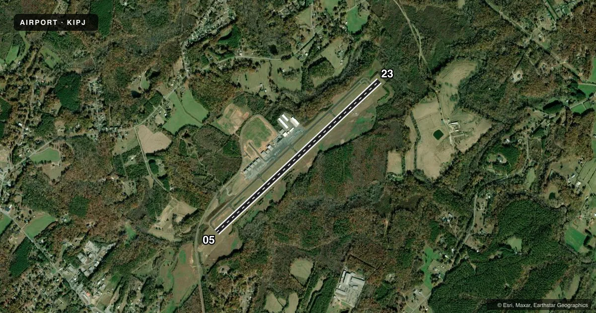
Runways & pattern
Full pagePattern entry · RWY 05
LEFT TRAFFICRunway end performance
| End | TORA | TODA | ASDA | LDA | VGSI | Approach lights | Obstruction |
|---|---|---|---|---|---|---|---|
| 05 | — | — | — | — | PAPI 2-box left(3.4°) | — | 110', trees, 2468' from thr, 386' R of cntrln, slope 20 |
| 23 | — | — | — | — | PAPI 2-box left(3°) | — | 30', trees, 1327' from thr, 449' R of cntrln, slope 37 |
Declared distances in feet. TORA = takeoff run available, TODA = takeoff distance, ASDA = accelerate-stop, LDA = landing distance.
Airport sketch
Runways drawn to scale from FAA survey coordinates, rendered over satellite imagery. Not for navigation.
Approaches & charts
ILS · 1
Services on the field
Fuel grades, oxygen, maintenance, ramp storage and lighting — as declared to the FAA by the airport operator.
Fuel & services
- Fuel
- 100LLA1+
- Oxygen (bottled)
- Low pressure
- Oxygen (bulk)
- Low pressure
- Airframe repair
- Major
- Power plant repair
- Major
- Other services
- INSTR,RNTL,SALES
Ramp & ground
- Transient storage
- Tie-down
- Landing fee
- No fee published
- Lighting schedule
- SEE RMK
- Beacon schedule
- SS-SR
- Beacon
- White / Green (civil land)(WG)
- Wind indicator
- Lighted
- Segmented circle
- Yes
Fuel & FBOs
Cheapest 100LL and Jet A on the field and nearby. Always confirm with the FBO before taxi.
Airport notes
Surface conditions, obstructions, local procedures, lighting outages and other notes published with each FAA cycle.
General notes
- RWY 23 HAS A 90 FT DROP-OFF 100 FT FM PVMT END AND 90 FT DROP-OFF FIRST 200 FT 160 FT BOTH SIDES OF CNTRLN.
- ARPT PHONE NR 704-735-0602.
- DEER, COYOTE & BIRDS ON & INVOF ARPT.
- FOR CD IF UNA VIA GCO CTC CHARLOTTE APCH AT 704-359-0241.
- GCO AVBL ON FREQ 124.900 THRU CHARLOTTE APCH; KEY MIKE 4 TIMES SLOWLY, WAIT FOR DIAL TONE AND RING.
Lighting notes
- TO ACTVT REIL RWY 05 & 23 DUSK-DAWN - CTAF; TO ACTVT PAPI RWY 05 & 23 - CTAF. MIRL RWY 05/23 DUSK TO 2200 PRESET LOW INTST; TO INCR INTST DUSK TO 2200 AND TO ACTVT MIRL RWY 05/23 BETWEEN 2200-DAWN - CTAF.
Runway surface & condition
- 05/23200 FT SWY SW END HAS BEEN REMARKED AS 200 FT DSPLCD THR FOR RWY 5.
Approach & departure obstructions
- 23DUE TO 11 FT BRUSH 104 FT FR RWY END OFFSET 10-173 FT RIGHT OF CNTRLN; DUE TO 13 FT BRUSH 31-115 FT FR RWY END OFFSET 143-164 FT LEFT OF CNTRLN.
- 05APCH SLOPE 18:1 AT DSPLCD THR.
- 23APCH SLOPE 31:1 AT DSPLCD THR.
Other notes
- 2UNATNDD THANKSGIVING AND CHRISTMAS DAY.
VFR map & nearby airports
VFR sectional. Tap any ICAO chip to open that airport.
Key facts · KIPJ
Answer card- ICAO
- KIPJ
- Name
- LINCOLN COUNTY RGNL
- Location
- LINCOLNTON, NORTH CAROLINA
- Elevation
- 877.9 ft MSL
- Traffic pattern altitude
- 1,877.9 ft MSL (1,000 AGL)
- Control tower
- Non-towered (use CTAF)
- Total runways
- 1
- Longest runway
- 05/23 · 5,700 ft
- Published ILS approaches
- 1
- Published frequencies
- 5
- Magnetic variation
- 6°
- Current flight rules
- LIFR
- Current wind
- 000° at 0 kt
- Favored runway now
- –
Lincoln County Rgnl sits in Lincolnton, North Carolina. The field elevation is 877.9 ft MSL. It has one runway, 05/23, at 5,700 ft. There is no control tower. Pattern altitude is not published, so use the standard 1,000 ft AGL for light piston operations unless the current FAA Chart Supplement says otherwise. That puts the pattern at about 1,877.9 ft MSL.
Runway 23 has the published ILS approach. The airport also has CTAF and UNICOM on 123.05. For clearance delivery, use 124.9 through the ground communications outlet when available, or contact Charlotte Approach if needed. The on-field FBO is Lincolnton-Lincoln County Regional Airport. It carries 100LL and Jet A. Call (704) 735-0602 before you go if you need current ramp or fuel availability.
The published remarks matter here. Runway lighting is pilot-controlled on the CTAF. The runway end identifier lights and PAPI for 05 and 23 are also activated that way. Runway 23 has brush and drop-off issues near the end, so treat the departure and arrival end with care. Deer, coyote and birds are reported on and near the airport. This is a non-towered field near Charlotte airspace, so expect to self-announce early and stay sharp on sequencing.