METAR & TAF KSVH
Current METAR
Observed 04:55Z
KSVH 270455Z AUTO 00000KT 10SM SCT065 23/23 A2995 RMK AO2 T02300228 402950217
- Wind
- 000° @ 0 kt
- Visibility
- 10 SM
- Temp / Dew
- 23°C / 23°C
- Altimeter
- 29.95 inHg
- Clouds
- SCT
- Density alt
- 2,123 ft
- Ceiling
- Unlimited
- Rules
- VFR
Airport info & contacts
Manager on record, flight service, ARTCC, attendance schedule and pattern altitude — published by the FAA and refreshed every 28 days.
Location
- From city
- 3 NM SW
- VFR sectional
- CHARLOTTE
- ARTCC
- ZTL · ATLANTA
- NOTAM facility
- SVH (NOTAM-D)
Airport manager
- Name
- JOHN M. FERGUSON
- Phone
- 704-873-1111
- Address
- 238 AIRPORT ROAD, STATESVILLE NC 28677
Flight service · Hours
- FSS RDU
- RALEIGH1-800-WX-BRIEF
- Attendance
- MON-FRI · 0700-2000
- SAT-SUN · 0800-2000
Frequencies
Tap any row to copy the frequency to your clipboard.
Runways & pattern
Full pagePattern entry · RWY 10
LEFT TRAFFICRunway end performance
| End | TORA | TODA | ASDA | LDA | VGSI | Approach lights | Obstruction |
|---|---|---|---|---|---|---|---|
| 10 | 7,003' | 7,003' | 6,453' | 6,453' | PAPI 4-box left(3°) | — | 49', trees, 671' from thr, 468' R of cntrln, slope 9 |
| 28 | 7,003' | 8,003' | 7,003' | 6,453' | PAPI 4-box left(3°) | MALSR | 46', trees, 1170' from thr, 560' R of cntrln, slope 21 |
Declared distances in feet. TORA = takeoff run available, TODA = takeoff distance, ASDA = accelerate-stop, LDA = landing distance.
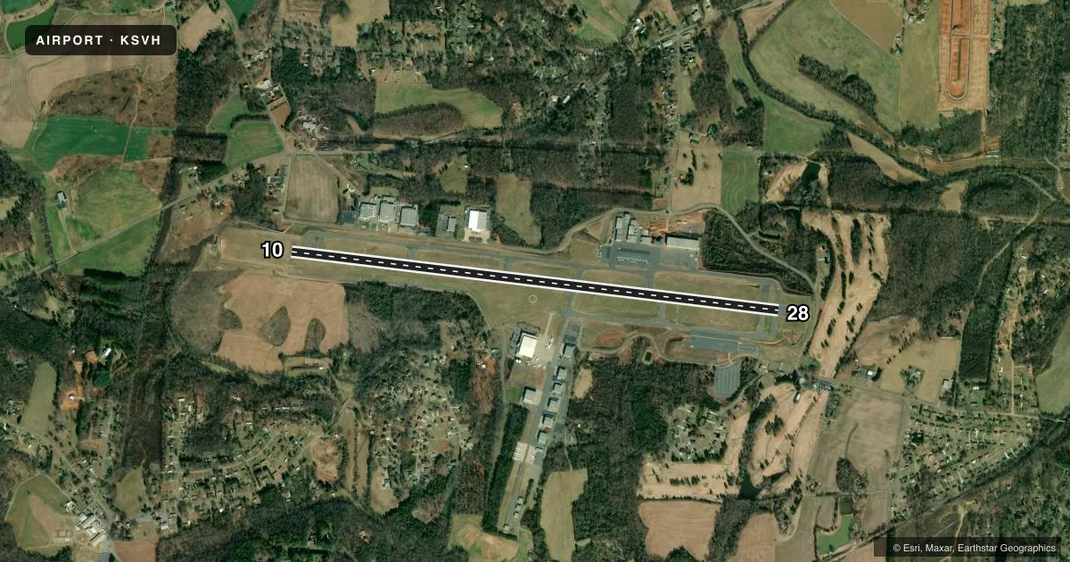
Airport sketch
Runways drawn to scale from FAA survey coordinates, rendered over satellite imagery. Not for navigation.
Approaches & charts
ILS · 1
Services on the field
Fuel grades, oxygen, maintenance, ramp storage and lighting — as declared to the FAA by the airport operator.
Fuel & services
- Fuel
- 100LLAA1+
- Oxygen (bottled)
- High pressure
- Oxygen (bulk)
- High pressure
- Airframe repair
- Major
- Power plant repair
- Major
- Other services
- AFRT,AMB,CHTR,INSTR,RNTL
Ramp & ground
- Transient storage
- Tie-down
- Hangar
- Landing fee
- No fee published
- Lighting schedule
- SEE RMK
- Beacon schedule
- SS-SR
- Beacon
- White / Green (civil land)(WG)
- Wind indicator
- Lighted
- Segmented circle
- Yes
Fuel & FBOs
Cheapest 100LL and Jet A on the field and nearby. Always confirm with the FBO before taxi.
Airport notes
Surface conditions, obstructions, local procedures, lighting outages and other notes published with each FAA cycle.
General notes
- RWY 28 HAS 100 FT DROP-OFF 250 FT RIGHT OF CNTRLN.
- NO LINE OF SIGHT BTN RWYS.
- FOR AFTER HRS NAVL/LGT FAILURE CALL 704-880-6897.
- FOR CD CTC ATLANTA ARTCC AT 770-210-7692.
- TWY A AT BOTH RWY ENDS HAS 80 FT TO 100 FT DROP-OFF 50 FT FM TWY CNTRLN.
Lighting notes
- ACTVT MALSR RWY 28; REIL RWY 10; PAPI RWY 10 & 28; HIRL RWY 10/28 - CTAF.
Approach & departure obstructions
- 28APCH SLP 34:1 AT DSPLCD THR DUE TO +43 FT TREES 1696 FT FM DSPLCD THR AND 617 FT LEFT OF CNTRLN.
Other notes
- EXISTED BEFORE 1959.
- 1FOR AFT HRS SVC CALL (704) 437-6617 OR (704) 880-6897.
VFR map & nearby airports
VFR sectional. Tap any ICAO chip to open that airport.
Key facts · KSVH
Answer card- ICAO
- KSVH
- Name
- STATESVILLE RGNL
- Location
- STATESVILLE, NORTH CAROLINA
- Elevation
- 967.8 ft MSL
- Traffic pattern altitude
- 1,967.8 ft MSL (1,000 AGL)
- Control tower
- Non-towered (use CTAF)
- Total runways
- 1
- Longest runway
- 10/28 · 7,003 ft
- Published ILS approaches
- 1
- Published frequencies
- 2
- Magnetic variation
- 8°
- Current flight rules
- VFR
- Current wind
- 000° at 0 kt
- Favored runway now
- –
Statesville Regional Airport sits in Statesville, North Carolina. Field elevation is 967.8 ft MSL. The airport has one runway, 10/28, which is 7,003 ft long. It is an untowered field. CTAF and UNICOM are both 123.075.
For instrument work, the field has one ILS approach to runway 28. Runway 28 also has MALSR lighting. Runway 10 has REIL. Both runway ends have PAPI. Both runways have high intensity runway lighting. Published remarks also note a 34 to 1 approach slope at the displaced threshold for runway 28 because of trees near the approach path. Taxiway A has steep drop-offs near both runway ends. Runway 28 also has a drop-off right of centerline. Use extra caution on taxi and on rollout.
Pattern altitude is not published. Use standard 1,000 ft AGL for light piston operations unless the current FAA Chart Supplement says otherwise. The on-field FBO is Statesville Regional Airport. It carries AVGAS 100LL and Jet A Prist. For after-hours service or lighting issues, the published remarks list phone numbers for assistance. If you are new to the field, review the current Chart Supplement before departure. The airport has no tower, so expect self-announce traffic and coordinate carefully on CTAF.