METAR & TAF KRUQ
Current METAR
Observed 05:15Z
KRUQ 270515Z AUTO 20005KT 10SM CLR 24/22 RMK AO2 T02360224
- Wind
- 200° @ 5 kt
- Visibility
- 10 SM
- Temp / Dew
- 24°C / 22°C
- Altimeter
- —
- Clouds
- CLR
- Density alt
- 2,038 ft
- Ceiling
- Unlimited
- Rules
- VFR
Airport info & contacts
Manager on record, flight service, ARTCC, attendance schedule and pattern altitude — published by the FAA and refreshed every 28 days.
Location
- From city
- 3 NM SW
- VFR sectional
- CHARLOTTE
- ARTCC
- ZTL · ATLANTA
- NOTAM facility
- RUQ (NOTAM-D)
Airport manager
- Name
- VALERIE STEELE
- Phone
- 704-216-7753
- Address
- 3670 AIRPORT LOOP, SALISBURY NC 28147-8921
Flight service · Hours
- FSS RDU
- RALEIGH1-800-WX-BRIEF
- Attendance
- 0800-2000
Frequencies
Tap any row to copy the frequency to your clipboard.
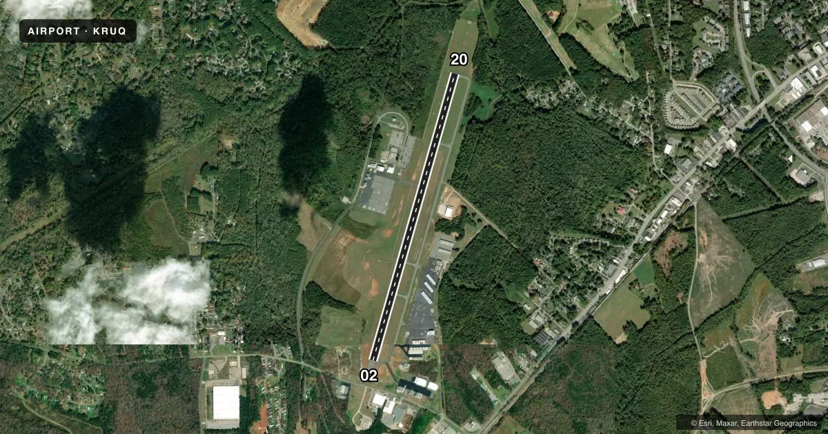
Runways & pattern
Full pagePattern entry · RWY 20
LEFT TRAFFICRunway end performance
| End | TORA | TODA | ASDA | LDA | VGSI | Approach lights | Obstruction |
|---|---|---|---|---|---|---|---|
| 02 | — | — | — | — | PAPI 2-box left(3°) | — | 35', trees, 814' from thr, 356' R of cntrln, slope 17 |
| 20 | — | — | — | — | PAPI 2-box left(3°) | MALSR | 23', trees, 231' from thr, 297' R of cntrln, slope 1 |
Declared distances in feet. TORA = takeoff run available, TODA = takeoff distance, ASDA = accelerate-stop, LDA = landing distance.
Airport sketch
Runways drawn to scale from FAA survey coordinates, rendered over satellite imagery. Not for navigation.
Approaches & charts
ILS · 1
Services on the field
Fuel grades, oxygen, maintenance, ramp storage and lighting — as declared to the FAA by the airport operator.
Fuel & services
- Fuel
- 100LLA1+
- Oxygen (bottled)
- Low pressure
- Oxygen (bulk)
- Not available
- Airframe repair
- Major
- Power plant repair
- Major
- Other services
- AFRT,AVNCS,CHTR,INSTR,PAJA,RNTL
Ramp & ground
- Transient storage
- Tie-down
- Hangar
- Landing fee
- No fee published
- Customs
- Not available
- Lighting schedule
- SEE RMK
- Beacon schedule
- SS-SR
- Beacon
- White / Green (civil land)(WG)
- Wind indicator
- Lighted
- Segmented circle
- Yes
Fuel & FBOs
Cheapest 100LL and Jet A on the field and nearby. Always confirm with the FBO before taxi.
Airport notes
Surface conditions, obstructions, local procedures, lighting outages and other notes published with each FAA cycle.
General notes
- ADDNL OBSTNS FOR RWY 02; 20 FT BLDG 1100 FT FM THR 100 FT R OF CNTRLN.
- 24 HR SVC BY REQ. FOR AFT HRS SVC CALL 980-892-2840.
- TRANSIT MIL FUEL.
- RMK: ARNG; LTD PRK RAMP CLSD TO ALL TFC EXC MIL ACFT WITH PPR. OPR 1200-2030Z++ MON-FRI EXC HOL.
- SKY DIVING OPS OVR ARPT; DO NOT OVERFLY ARPT DRG SKY DIVING OPS.
- MAIN TRML APRON GRASS AREA ADJ TO FUEL PUMPS CLSD TO HELS.
- BE ALERT FOR MIL ROTOR WING TFC. RNG RAMP LCTD W OF RWY. FRQ NGT OPS.
- CTC KILLDEVIL OPS 10 MIN PRIOR TO LDG. RNG OPS FREQ - 40.700, 126.100, 293.000.
- FOR CD CTC CHARLOTTE APCH AT 704-359-0241.
Lighting notes
- ACTVT MALSR RWY 20; REIL RWY 02 & 20; PAPI RWY 02 & 20; MIRL RWY 02/20 - CTAF.
Fuel notes
- 100LL24 SELF SERVICE AVBL FOR 100LL WITH CREDIT CARD.
- A1+MIL FUEL A+ CTC KILLDEVIL OPS 24 HR PPR, C 984-661-6506/6507/6557.
Approach & departure obstructions
- 2015 FT TREES 0-200 FT FM THR OFFSET 325 FT LEFT OF CNTRLN.
- 02APCH RATIO 22:1 AT DSPLCD DUE TO 41 FT TREES 1123 FT FM THR OFFSET 418 LEFT OF CNTRLN.
Other notes
- 2UNATNDD THANKSGIVING AND CHRISTMAS DAY. TO SKED AFT HRS OR HOLIDAY SVC CALL 980-892-2840.
VFR map & nearby airports
VFR sectional. Tap any ICAO chip to open that airport.
Key facts · KRUQ
Answer card- ICAO
- KRUQ
- Name
- MID-CAROLINA RGNL
- Location
- SALISBURY, NORTH CAROLINA
- Elevation
- 772.3 ft MSL
- Traffic pattern altitude
- 1,772.3 ft MSL (1,000 AGL)
- Control tower
- Non-towered (use CTAF)
- Total runways
- 1
- Longest runway
- 02/20 · 5,501 ft
- Published ILS approaches
- 1
- Published frequencies
- 5
- Magnetic variation
- 6°
- Current flight rules
- VFR
- Current wind
- 200° at 5 kt
- Favored runway now
- RWY 20
Mid-Carolina Regional Airport sits in Salisbury, North Carolina. Field elevation is 772.3 ft MSL. The airport has one runway. Runway 02/20 is 5,501 ft long with asphalt pavement. There is no control tower. The published pattern altitude is not given, so use the current FAA Chart Supplement before you fly. The airport has one ILS approach to runway 20. Runway 20 also has MALSR, REIL and PAPI. Runway 02 has REIL and PAPI.
The on-field FBO is Mid-Carolina Regional Airport. It carries 100LL and Jet A. Call ahead if you need service. Published remarks say operations run from 1200 to 2030 Zulu Monday through Friday except holidays. They also note limited parking ramp access. That ramp is closed to all traffic except military aircraft with prior permission. The main terminal apron grass area by the fuel pumps is closed to helicopters. Be alert for military rotor wing traffic, range ramp activity west of the runway and skydiving operations over the field. Do not overfly the airport during jump activity.
For a first-time arrival, the main things to plan for are the military activity, the published runway 02 obstruction notes and the fact that runway lights are controlled by CTAF. Contact the airport operator or the FBO directly before arrival if you need current access details or after-hours service.