METAR & TAF KVUJ
Current METAR
Observed 09:55Z
KVUJ 270955Z AUTO 00000KT 7SM BKN005 21/20 A2991 RMK AO2 T02050203
- Wind
- 000° @ 0 kt
- Visibility
- 7 SM
- Temp / Dew
- 21°C / 20°C
- Altimeter
- 29.91 inHg
- Clouds
- BKN
- Density alt
- 1,488 ft
- Ceiling
- 500 ft AGL
- Rules
- IFR
Airport info & contacts
Manager on record, flight service, ARTCC, attendance schedule and pattern altitude — published by the FAA and refreshed every 28 days.
Location
- From city
- 4 NM NE
- VFR sectional
- CHARLOTTE
- ARTCC
- ZTL · ATLANTA
- NOTAM facility
- VUJ (NOTAM-D)
Airport manager
- Name
- RANDY SHANK
- Phone
- 704-982-9013
- Address
- 43222 LOWDER AVIATION PARKWAY, NEW LONDON NC 28127
Flight service · Hours
- FSS RDU
- RALEIGH1-800-WX-BRIEF
- Attendance
- 0800-1800
Frequencies
Tap any row to copy the frequency to your clipboard.
Runways & pattern
Full pagePattern entry · RWY 04R
LEFT TRAFFIC| Runway | Heading (°M) | Length | Surface | Traffic |
|---|---|---|---|---|
| 04R/22L | 31° / 211° | 5,499 ft | ASPH | Standard L |
| 04L/22R | 31° / 211° | 3,501 ft | ASPH | Standard L |
Runway end performance
| End | TORA | TODA | ASDA | LDA | VGSI | Approach lights | Obstruction |
|---|---|---|---|---|---|---|---|
| 04R | — | — | — | — | PAPI 2-box left(3°) | — | 32', trees, 375' from thr, 488' R of cntrln, slope 5 |
| 22L | — | — | — | — | PAPI 2-box left(3°) | — | 137', trees, 4194' from thr, 176' R of cntrln, slope 29 |
| 04L | — | — | — | — | — | — | 23', fence, 411' from thr, 301' R of cntrln, slope 9 |
| 22R | — | — | — | — | — | — | 32', trees, 793' from thr, 270' R of cntrln, slope 18 |
Declared distances in feet. TORA = takeoff run available, TODA = takeoff distance, ASDA = accelerate-stop, LDA = landing distance.
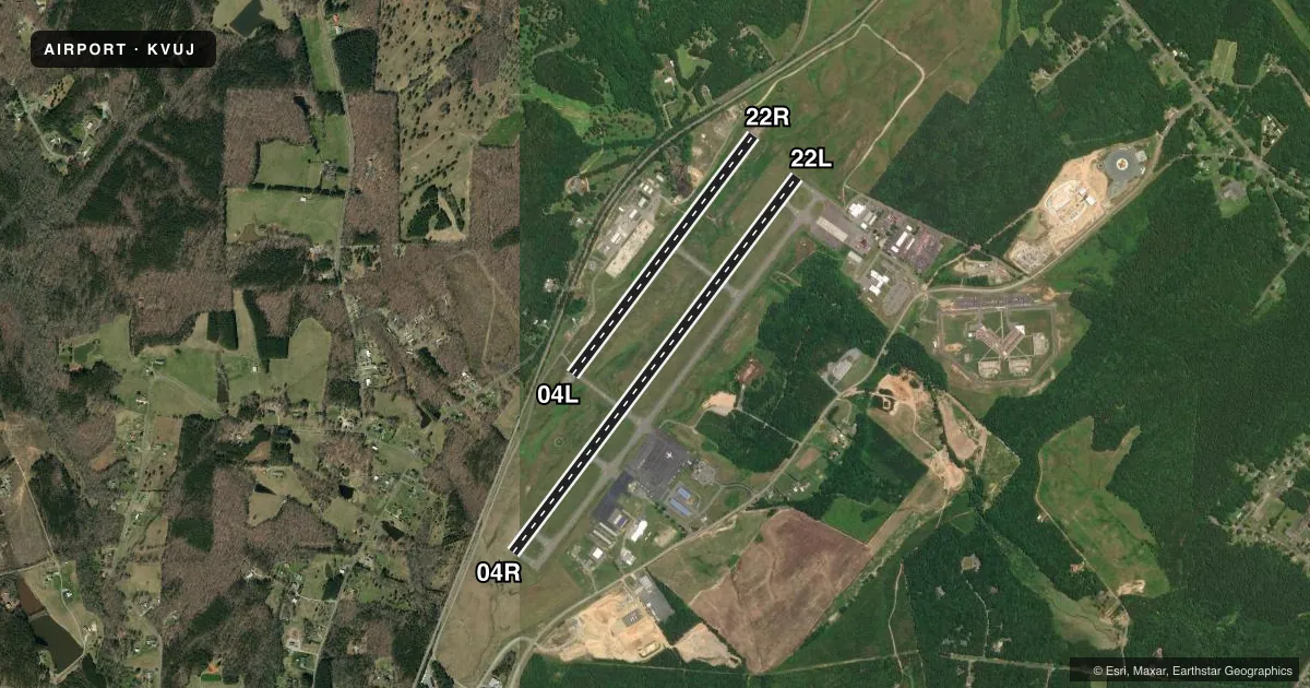
Airport sketch
Runways drawn to scale from FAA survey coordinates, rendered over satellite imagery. Not for navigation.
Approaches & charts
ILS · 1
Services on the field
Fuel grades, oxygen, maintenance, ramp storage and lighting — as declared to the FAA by the airport operator.
Fuel & services
- Fuel
- 100LLA+A1+
- Oxygen (bottled)
- Not available
- Oxygen (bulk)
- Low pressure
- Airframe repair
- Major
- Power plant repair
- Major
- Other services
- INSTR,PAJA,RNTL
Ramp & ground
- Transient storage
- Tie-down
- Hangar
- Landing fee
- No fee published
- Lighting schedule
- SEE RMK
- Beacon schedule
- SS-SR
- Beacon
- White / Green (civil land)(WG)
- Wind indicator
- Lighted
- Segmented circle
- Yes
Fuel & FBOs
Cheapest 100LL and Jet A on the field and nearby. Always confirm with the FBO before taxi.
Airport notes
Surface conditions, obstructions, local procedures, lighting outages and other notes published with each FAA cycle.
General notes
- 959 FT MSL LGTD TWR 1.5NW.
- RSTD: ANG RAMP RSTD TO MIL USE ONLY WITH PPR. CTC 235 CAOS/ATM DSN 484-2551, C704-422-2551 OR C704-763-4633 AFT DUTY HOURS.
- CAUTION: BE ALERT FOR HIGH SPEED LOW LEVEL MIL ACFT IN VCNTY. FRQ NGT MIL OPR. FREQ ASSAULT OPS TO RWY 22R. DEER AND BIRD HAZARD.
- MISC: REGIONAL TRAINING SITE (RTS) SUPPORT COORD THRU 145 AW/CE DSN 231-4229.
- ANG: PPR ONLY IF UTILIZING ANG RAMP AND FBO RAMP, 235 CAOS/ATM C704-422-2551.
- HEAVY PARACHUTE JUMPING NORTH END OF RWY 22L/R.
- FOR CD WHEN ATCT IS CLSD CTC CHARLOTTE APCH AT 704-359-0241.
- FBO OPERATIONAL HRS 0800-1800.
- MILITARY FUEL - A+ (C704-982-9013, 1300-0000Z++, OT C704-984-3542 OR C704-961-8964) (NC-100LL). FUEL AVBL FROM FBO 1400-2200Z++, OTHER TIMES PPR, C704-982-9013.
Lighting notes
- ACTVT REIL RWY 04R & 22L; HIRL RWY 04R/22L; MIRL RWY 04L/22R - CTAF. PAPI RWY 04R & 22L ON DRG TWR OPN, OTHER TIMES - CTAF.
Fuel notes
- 100LL100LL AVBL SELF SVC H24 WITH CREDIT CARD.
Approach & departure obstructions
- 04L10 FT HILL 0-200 FT FROM THR 200 FT LEFT OF CNTRLN.
Other notes
- TPA: HEL 500 FT (1200 FT MSL), SMALL FW 1000 FT (1700 MSL), LRG/HVY 1500 FT (2200 FT MSL), OVHD 1500 FT (2200 FT MSL) OR AS ASGND BY TWR.
VFR map & nearby airports
VFR sectional. Tap any ICAO chip to open that airport.
Key facts · KVUJ
Answer card- ICAO
- KVUJ
- Name
- STANLY COUNTY
- Location
- ALBEMARLE, NORTH CAROLINA
- Elevation
- 609 ft MSL
- Traffic pattern altitude
- 1,609 ft MSL (1,000 AGL)
- Control tower
- Towered · 1300-2230Z++ OR BY NOTAM.
- Total runways
- 2
- Longest runway
- 04R/22L · 5,499 ft
- Published ILS approaches
- 1
- Published frequencies
- 9
- Magnetic variation
- 6°
- Current flight rules
- IFR
- Current wind
- 000° at 0 kt
- Favored runway now
- –
Stanly County Airport sits in Albemarle, North Carolina. The field elevation is 609 ft MSL. It has two asphalt runways. The longest is 5,499 ft on 04R/22L. The other runway is 3,501 ft on 04L/22R. The airport has a control tower. Tower hours are 1300-2230Z or by NOTAM.
One ILS approach is published for runway 22L. The traffic pattern altitude for small fixed-wing aircraft is 1,700 ft MSL. That is 1,000 ft AGL. Helicopters use 1,200 ft MSL. The field is in a busy military training environment. Expect high speed low level traffic. Night military ops are frequent. Assault operations to 22R are also frequent. Heavy parachute jumping occurs at the north end of 22L and 22R. There is also a deer and bird hazard.
Stanly County Airport has one on-field FBO. Stanly County Airport carries 100LL and Jet A Prist. 100LL is also available self-service 24 hours a day with a credit card. The published remarks also note a hill near the 04L threshold. It sits 0 to 200 ft from the threshold. It is about 200 ft left of centerline. If you are planning to use the Air National Guard ramp or the FBO ramp, check the current Chart Supplement and call ahead for permission. For clearance delivery when the tower is closed, contact Charlotte Approach.