METAR & TAF 43A
43A does not publish a METAR.
Showing the nearest reporting station: KHBI (ASHEBORO RGNL) · 17.0 NM away. Conditions at 43A may differ.
METAR · KHBI
Observed 07:15Z
KHBI 270715Z AUTO 00000KT 10SM SCT007 SCT022 BKN033 22/22 A2990 RMK AO2
- Wind
- 000° @ 0 kt
- Visibility
- 10 SM
- Temp / Dew
- 22°C / 22°C
- Altimeter
- 29.90 inHg
- Clouds
- BKN
- Density alt
- 1,649 ft
- Ceiling
- 3,300 ft AGL
- Rules
- VFR
Airport info & contacts
Manager on record, flight service, ARTCC, attendance schedule and pattern altitude — published by the FAA and refreshed every 28 days.
Location
- From city
- 0 NM NE
- VFR sectional
- CHARLOTTE
- ARTCC
- ZDC · WASHINGTON
- NOTAM facility
- RDU (NOTAM-D)
Airport manager
- Name
- KEVIN MCNEILL
- Phone
- (910) 220-1218
- Address
- PO BOX 425, TROY NC 27371
Flight service · Hours
- FSS RDU
- RALEIGH1-800-WX-BRIEF
- Attendance
- UNATTENDED
Frequencies
Tap any row to copy the frequency to your clipboard.
Runways & pattern
Full pagePattern entry · RWY 03
LEFT TRAFFICRunway end performance
| End | TORA | TODA | ASDA | LDA | VGSI | Approach lights | Obstruction |
|---|---|---|---|---|---|---|---|
| 03 | — | — | — | — | PAPI 2-box left(3.5°) | — | 43', trees, 1453' from thr, 46' R of cntrln, slope 29 |
| 21 | — | — | — | — | PAPI 2-box left(4°) | — | 26', pole, 456' from thr, 108' R of cntrln, slope 9 |
Declared distances in feet. TORA = takeoff run available, TODA = takeoff distance, ASDA = accelerate-stop, LDA = landing distance.
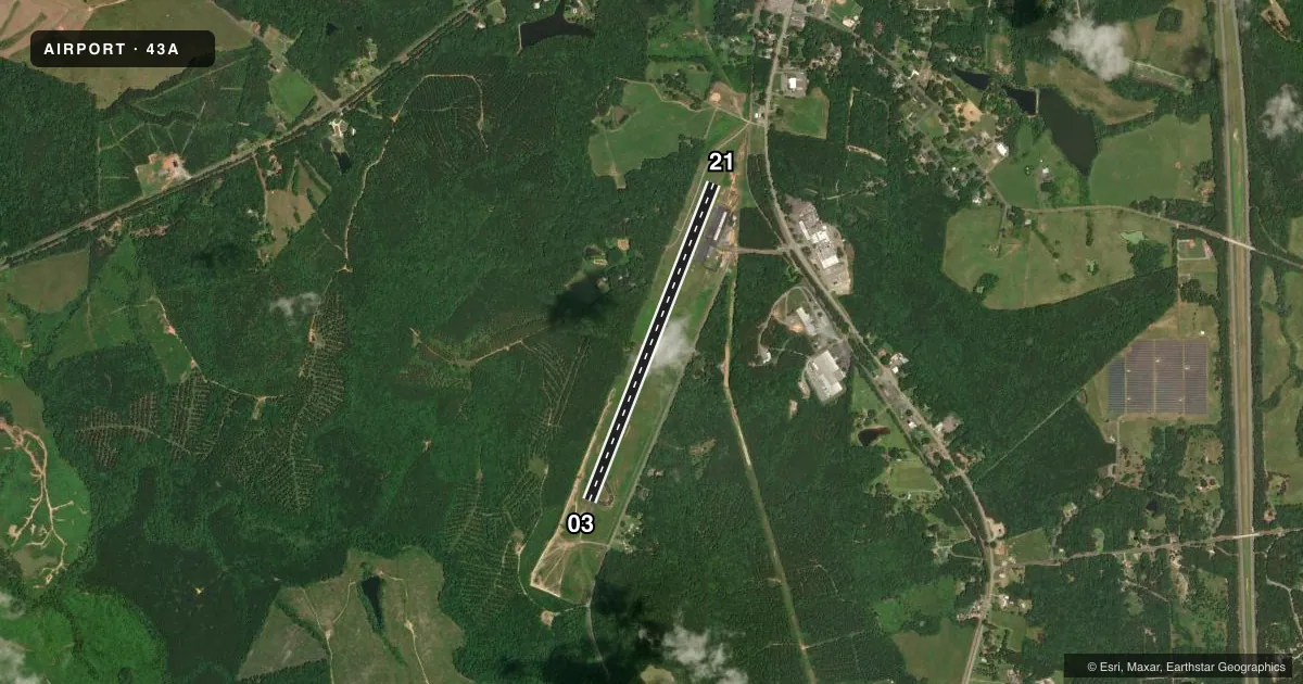
Airport sketch
Runways drawn to scale from FAA survey coordinates, rendered over satellite imagery. Not for navigation.
Approaches & charts
Services on the field
Fuel grades, oxygen, maintenance, ramp storage and lighting — as declared to the FAA by the airport operator.
Fuel & services
- Fuel
- 100LL
- Oxygen (bottled)
- Not available
- Oxygen (bulk)
- Not available
- Airframe repair
- Not available
- Power plant repair
- Not available
Ramp & ground
- Transient storage
- Tie-down
- Landing fee
- No fee published
- Customs
- Not available
- Lighting schedule
- SEE RMK
- Beacon schedule
- SS-SR
- Beacon
- White / Green (civil land)(WG)
- Wind indicator
- Lighted
- Segmented circle
- No
Fuel & FBOs
Cheapest 100LL and Jet A on the field and nearby. Always confirm with the FBO before taxi.
Airport notes
Surface conditions, obstructions, local procedures, lighting outages and other notes published with each FAA cycle.
General notes
- CTN: DEER ON AND INVOF RWY.
- UNMARKED 40 FT PLINE 350-750 FT FM THR RWY 21 ACROSS & L OF CNTRLN.
- 20-25 FT DEPRESSION 180 FT SOUTH OF RWY 03 THR ON CNTRLN.
- RWY 03 HAS UPHILL GRADE.
- 35-40 FT DROP-OFF 80 FT WEST OF RWY 03 CNTRLN; 30 FT DROP-OFF 300 FT FM RWY 21 THR ON CNTRLN; 30 FT DROP-OFF 80 FT RIGHT OF RWY 21 CNTRLN.
- FOR CD CTC FAYETTEVILLE APCH AT 910-484-8012.
- RWY 21 HAS A PARALLEL GRAVEL DRIVEWAY 130 FT RIGHT OF CNTRLN.
Lighting notes
- ACTVT PAPI RWY 03 & 21; MIRL RWY 03/21 - CTAF.
Fuel notes
- 100LLAVGAS 100LL 24 HR SELF SVC WITH CREDIT CARD.
Approach & departure obstructions
- 21APCH RATIO 24:1 TO DTHR.
Other notes
- VFR OPERATIONS ONLY.
- MANAGERMGR PHONE 910-220-1218.
VFR map & nearby airports
VFR sectional. Tap any ICAO chip to open that airport.
Key facts · 43A
Answer card- ICAO
- 43A
- Name
- MONTGOMERY COUNTY
- Location
- STAR, NORTH CAROLINA
- Elevation
- 632.5 ft MSL
- Traffic pattern altitude
- 1,632.5 ft MSL (1,000 AGL)
- Control tower
- Non-towered (use CTAF)
- Total runways
- 1
- Longest runway
- 03/21 · 4,002 ft
- Published ILS approaches
- 0
- Published frequencies
- 4
- Magnetic variation
- 6°
- Current flight rules
- VFR
- Current wind
- 000° at 0 kt
- Favored runway now
- –
Montgomery County Airport (43A) is in Star, North Carolina. The field elevation is 632.5 ft MSL. It has one runway, 03/21, which is 4,002 ft long. There is no control tower. The airport is VFR only. No ILS approaches are published.
Pattern altitude is not published. Use the standard 1,000 ft AGL pattern unless the current FAA Chart Supplement or the airport operator says otherwise. The published remarks matter here. There is a steep drop-off west of runway 03 and more terrain issues near both ends of the runway. Deer are also a known hazard on and near the runway. Runway 21 has a parallel gravel driveway off the right side. There is also an unmarked pipeline near the 21 approach path.
24-hour self-serve 100LL is available with credit card. No on-field FBOs are listed. Call the airport operator directly before arrival if you need ramp or service details. Fayetteville Approach handles clearance delivery and the published approach frequencies. The runway lights are on CTAF. PAPI is available for both runway ends. First-time pilots should plan a careful look at the terrain. Stay alert for wildlife. Verify current procedures before flying in.