METAR & TAF KSOP
Current METAR
Observed 09:56Z
KSOP 270956Z AUTO 00000KT 6SM BR CLR 22/22 A2987 RMK AO2 SLP114 T02170217 $
- Wind
- 000° @ 0 kt
- Visibility
- 6 SM
- Temp / Dew
- 22°C / 22°C
- Altimeter
- 29.87 inHg
- Clouds
- CLR
- Density alt
- 1,472 ft
- Ceiling
- Unlimited
- Rules
- VFR
Airport info & contacts
Manager on record, flight service, ARTCC, attendance schedule and pattern altitude — published by the FAA and refreshed every 28 days.
Location
- From city
- 3 NM N
- VFR sectional
- CHARLOTTE
- ARTCC
- ZDC · WASHINGTON
- NOTAM facility
- SOP (NOTAM-D)
Airport manager
- Name
- RICK CLOUTIER
- Phone
- 910-692-3212
- Address
- P.O. DRAWER 5809, PINEHURST NC 28374
Flight service · Hours
- FSS RDU
- RALEIGH1-800-WX-BRIEF
- Attendance
- 0800-2000
Frequencies
Tap any row to copy the frequency to your clipboard.
Runways & pattern
Full pagePattern entry · RWY 05
LEFT TRAFFICRunway end performance
| End | TORA | TODA | ASDA | LDA | VGSI | Approach lights | Obstruction |
|---|---|---|---|---|---|---|---|
| 05 | 6,502' | 6,502' | 6,102' | 5,502' | PAPI 4-box left(3°) | MALSR | 71', trees, 1740' from thr, 456' R of cntrln, slope 21 |
| 23 | 6,502' | 6,502' | 6,102' | 5,722' | PAPI 4-box right(3°) | — | 38', trees, 987' from thr, 185' R of cntrln, slope 20 |
Declared distances in feet. TORA = takeoff run available, TODA = takeoff distance, ASDA = accelerate-stop, LDA = landing distance.
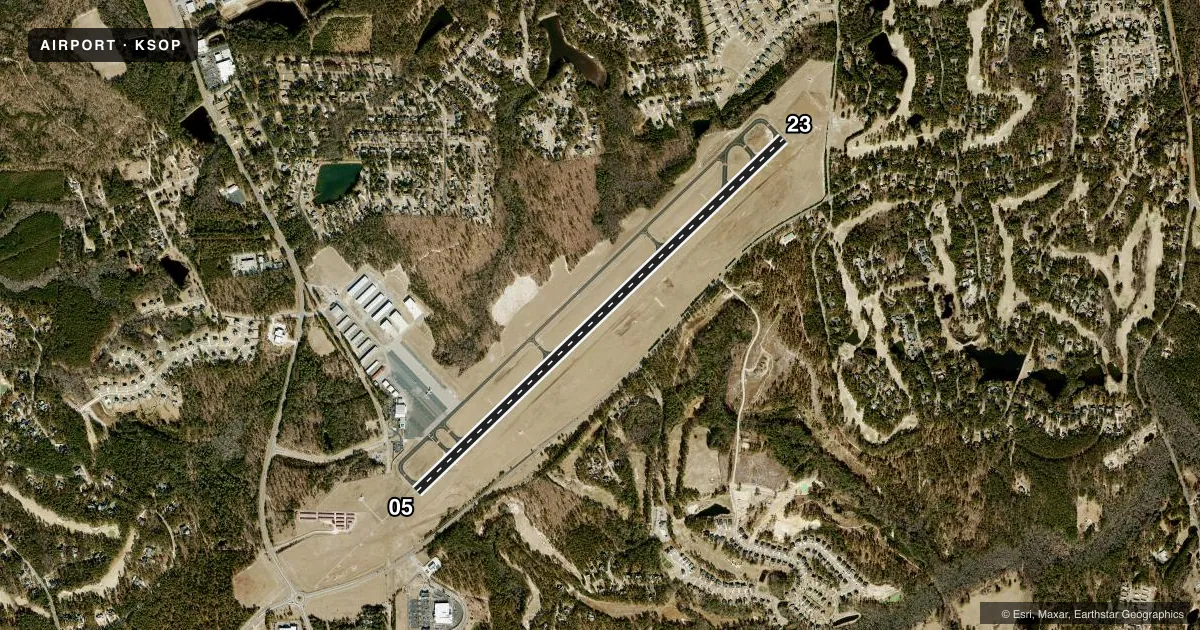
Airport sketch
Runways drawn to scale from FAA survey coordinates, rendered over satellite imagery. Not for navigation.
Approaches & charts
ILS · 1
Services on the field
Fuel grades, oxygen, maintenance, ramp storage and lighting — as declared to the FAA by the airport operator.
Fuel & services
- Fuel
- 100LLA+
- Oxygen (bottled)
- High pressure
- Oxygen (bulk)
- Not available
- Airframe repair
- Major
- Power plant repair
- Major
- Other services
- CHTR,INSTR,RNTL
Ramp & ground
- Transient storage
- Tie-down
- Hangar
- Landing fee
- No fee published
- Customs
- Not available
- Lighting schedule
- SEE RMK
- Beacon schedule
- SS-SR
- Beacon
- White / Green (civil land)(WG)
- Wind indicator
- Lighted
- Segmented circle
- No
Fuel & FBOs
Cheapest 100LL and Jet A on the field and nearby. Always confirm with the FBO before taxi.
Airport notes
Surface conditions, obstructions, local procedures, lighting outages and other notes published with each FAA cycle.
General notes
- NOISE ABATEMENT PROCEDURES IN EFFECT. CTC AMGR 910-692-3212.
- BIRD ACTVTY ON & INVOF ARPT APR-OCT.
- 12 HR PPR FOR JET OPNS CONDUCTED 2300-0600, CTC AMGR 910-692-3212.
- MAINT AVBL.
- FLT TRNG AVBL.
- FOR CD CTC FAYETTEVILLE APCH 910-484-8012.
- FIXED WING AIRCRAFT OPERATIONS NOT AUTHORIZED FROM ANY GRASS/TURF SURFACE.
Lighting notes
- ACTVT MALSR RWY 05; REIL RWY 23; HIRL RWY 05/23; TWY LGTS - CTAF. PAPI RWY 05 & 23 OPERS CONSLY.
Approach & departure obstructions
- 05APCH RATIO 30:1 AT DSPLCD THR 72 FT TREES.
Other notes
- CLSD TO UNSKED AIR CARRIER OPER WITH MORE THAN 30 PASSENGER SEATS; CALL AMGR 910-692-3212.
VFR map & nearby airports
VFR sectional. Tap any ICAO chip to open that airport.
Key facts · KSOP
Answer card- ICAO
- KSOP
- Name
- MOORE COUNTY
- Location
- PINEHURST/SOUTHERN PINES, NORTH CAROLINA
- Elevation
- 459.3 ft MSL
- Traffic pattern altitude
- 1,459.3 ft MSL (1,000 AGL)
- Control tower
- Non-towered (use CTAF)
- Total runways
- 1
- Longest runway
- 05/23 · 6,503 ft
- Published ILS approaches
- 1
- Published frequencies
- 5
- Magnetic variation
- 8°
- Current flight rules
- VFR
- Current wind
- 000° at 0 kt
- Favored runway now
- –
Moore County Airport sits in Pinehurst and Southern Pines, North Carolina. Field elevation is 459.3 ft MSL. The airport has one runway, 05/23, which is 6,503 ft long. There is no control tower. Pattern altitude is not published, so use the standard 1,000 ft AGL for light piston operations unless the current Chart Supplement says otherwise.
Runway 05 has an ILS approach. The airport also has MALSR lighting on runway 05. Runway end identifier lights are installed on runway 23. High intensity runway lights are installed on both ends. PAPI on 05 and 23 operates continuously. Taxiway lights operate on the CTAF frequency. Bird activity is reported from April through October, so plan for that on arrival and departure. The published remarks also say fixed wing aircraft are not authorized from any grass or turf surface.
Moore County Airport has one on-field FBO. Moore County Airport carries 100LL and Jet A with Prist availability. Noise abatement procedures are in effect. Contact the airport manager at 910-692-3212 for current guidance. Jet operations between 2300 and 0600 need 12 hours prior permission. Clearance delivery is handled through Fayetteville Approach. This is a non-towered field, so expect self-announce traffic on CTAF 123.05 and coordinate closely with other aircraft in the pattern.