METAR & TAF KRCZ
Current METAR
Observed 08:55Z
KRCZ 270855Z AUTO 00000KT 5SM CLR 22/22 A2985 RMK AO2 T02230217
- Wind
- 000° @ 0 kt
- Visibility
- 5 SM
- Temp / Dew
- 22°C / 22°C
- Altimeter
- 29.85 inHg
- Clouds
- CLR
- Density alt
- 1,370 ft
- Ceiling
- Unlimited
- Rules
- MVFR
Airport info & contacts
Manager on record, flight service, ARTCC, attendance schedule and pattern altitude — published by the FAA and refreshed every 28 days.
Location
- From city
- 3 NM S
- VFR sectional
- CHARLOTTE
- ARTCC
- ZDC · WASHINGTON
- NOTAM facility
- RCZ (NOTAM-D)
Airport manager
- Name
- JEFF PRESSLEY
- Phone
- 910-206-0419
- Address
- 656 AIRPORT ROAD, ROCKINGHAM NC 28379
Flight service · Hours
- FSS RDU
- RALEIGH1-800-WX-BRIEF
- Attendance
- MON-FRI · 0800-1700
Frequencies
Tap any row to copy the frequency to your clipboard.
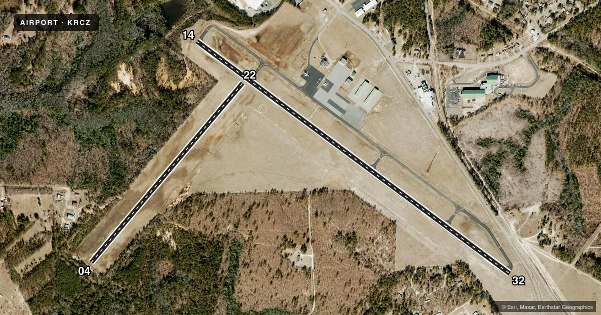
Runways & pattern
Full pagePattern entry · RWY 14
LEFT TRAFFIC| Runway | Heading (°M) | Length | Surface | Traffic |
|---|---|---|---|---|
| 14/32 | 119° / 299° | 5,001 ft | ASPH | Standard L |
| 04/22 | 33° / 213° | 3,009 ft | TURF | Standard L |
Runway end performance
| End | TORA | TODA | ASDA | LDA | VGSI | Approach lights | Obstruction |
|---|---|---|---|---|---|---|---|
| 14 | — | — | — | — | PAPI 2-box left(3°) | — | 14', trees, 207' from thr, 76' R of cntrln, slope 0 |
| 32 | — | — | — | — | PAPI 2-box left(3°) | — | 20', rr, 215' from thr, 243' R of cntrln, slope 0 |
| 04 | — | — | — | — | — | — | 39', trees, 75' from thr, 66' R of cntrln, slope 1 |
| 22 | — | — | — | — | — | — | 78', trees, 1979' from thr, 282' R of cntrln, slope 25 |
Declared distances in feet. TORA = takeoff run available, TODA = takeoff distance, ASDA = accelerate-stop, LDA = landing distance.
Airport sketch
Runways drawn to scale from FAA survey coordinates, rendered over satellite imagery. Not for navigation.
Approaches & charts
Services on the field
Fuel grades, oxygen, maintenance, ramp storage and lighting — as declared to the FAA by the airport operator.
Fuel & services
- Fuel
- 100LLA1+
- Oxygen (bottled)
- Not available
- Oxygen (bulk)
- Not available
- Airframe repair
- Not available
- Power plant repair
- Not available
Ramp & ground
- Transient storage
- Tie-down
- Landing fee
- No fee published
- Customs
- Not available
- Lighting schedule
- SEE RMK
- Beacon schedule
- SS-SR
- Beacon
- White / Green (civil land)(WG)
- Wind indicator
- Lighted
- Segmented circle
- Yes
Fuel & FBOs
Cheapest 100LL and Jet A on the field and nearby. Always confirm with the FBO before taxi.
Airport notes
Surface conditions, obstructions, local procedures, lighting outages and other notes published with each FAA cycle.
General notes
- RWY 14 HAS 60 FT DROP-OFF 350 FT FROM DSPLCD THR ALL SIDES.
- RWY 04/22 NOT IN USE WHEN WET - TURBINE ENGINE ACFT AND ACFT OVER 10K LBS. CALL 910-997-5071 FOR RUNWAY CONDITIONS BEFORE LANDING.
- FOR CD CTC WASHINGTON ARTCC AT 703-771-3587.
- RWY 32 HAS NUMEROUS OBSTRUCTIONS IN APCH INCLUDING 5 FT FENCE, 12 FT ROAD, AND 20 FT RAILROAD.
Lighting notes
- ACTVT DUSK TO DAWN. REIL RWY 32; PAPI RWY 14 & 32; MIRL RWY 14/32 - CTAF.
Fuel notes
- 100LL100LL AND JET A - 24 HR SELF-SERVICE WITH CREDIT CARD.
Approach & departure obstructions
- 3215 FT ROAD, 5 FT FENCE, AND 20 FT RAILROAD ALL 0-200 FT FM RWY END OFFSET BETWEEN 90-200 FT RIGHT OF CNTRLN.
- 14APCH SLOPE 9:1 AT DSPLCD THR DUE TO 16 FT TREES 357 FT FROM DSPLCD THR OFFSET 71 FT RIGHT OF CNTRLN.
- 32APCH SLOPE 11:1 AT DSPLCD THR DUE TO 20 FT RAILROAD 439 FT FROM DSPLCD THR 235 FT RIGHT OF CNTRLN.
Other notes
- 1UNATNDD SAT, SUN AND FEDERAL HOLS.
- 1FOR ARPT ATTENDANT NGTS AND SUN CALL 910-997-5071.
VFR map & nearby airports
VFR sectional. Tap any ICAO chip to open that airport.
Key facts · KRCZ
Answer card- ICAO
- KRCZ
- Name
- RICHMOND COUNTY
- Location
- ROCKINGHAM, NORTH CAROLINA
- Elevation
- 357.5 ft MSL
- Traffic pattern altitude
- 1,357.5 ft MSL (1,000 AGL)
- Control tower
- Non-towered (use CTAF)
- Total runways
- 2
- Longest runway
- 14/32 · 5,001 ft
- Published ILS approaches
- 0
- Published frequencies
- 4
- Magnetic variation
- 8°
- Current flight rules
- MVFR
- Current wind
- 000° at 0 kt
- Favored runway now
- –
Richmond County Airport is in Rockingham, North Carolina. Field elevation is 357.5 ft MSL. The airport has two runways. The longest is 14/32 at 5,001 ft. Runway 04/22 is turf and measures 3,009 ft. There is no control tower. Use CTAF 122.8 for local traffic. Fayetteville Approach and Departure are on 127.8 and 343.725.
No ILS approaches are published here. Pattern altitude is not published, so plan on the standard 1,000 ft AGL for light piston traffic unless the current Chart Supplement says otherwise. The on-field FBO is Richmond County Airport. It carries 100LL and Jet A. Fuel is available 24 hours self-service with credit card. The airport is unattended Saturday, Sunday and federal holidays. For airport attendant nights and Sunday call the airport number before you go.
This field has some runway-specific caution items. Runway 32 has obstructions near the approach, including a fence, road and railroad. Runway 14 has a steep drop-off beyond the displaced threshold area. It also has trees on the approach side. Runways 04 and 22 are not in use when wet for turbine aircraft and aircraft over 10,000 lb. If you need clearance delivery, contact Washington ARTCC. Check runway condition before landing if weather has been wet.