METAR & TAF KUDG
Current METAR
Observed 06:56Z
KUDG 270656Z AUTO 00000KT 5SM BR CLR 23/23 A2987 RMK AO2 SLP113 T02280228 $
- Wind
- 000° @ 0 kt
- Visibility
- 5 SM
- Temp / Dew
- 23°C / 23°C
- Altimeter
- 29.87 inHg
- Clouds
- CLR
- Density alt
- 1,260 ft
- Ceiling
- Unlimited
- Rules
- MVFR
Airport info & contacts
Manager on record, flight service, ARTCC, attendance schedule and pattern altitude — published by the FAA and refreshed every 28 days.
Location
- From city
- 9 NM N
- VFR sectional
- CHARLOTTE
- ARTCC
- ZJX · JACKSONVILLE
- NOTAM facility
- UDG (NOTAM-D)
Airport manager
- Name
- BARRY KENNETT
- Phone
- 843-393-9928
- Address
- 313 G.GRAHAM SEGARS PARKWAY, DARLINGTON SC 29540
Flight service · Hours
- FSS AND
- ANDERSON1-800-WX-BRIEF
- Attendance
- MON-FRI · 0800-1700
Frequencies
Tap any row to copy the frequency to your clipboard.
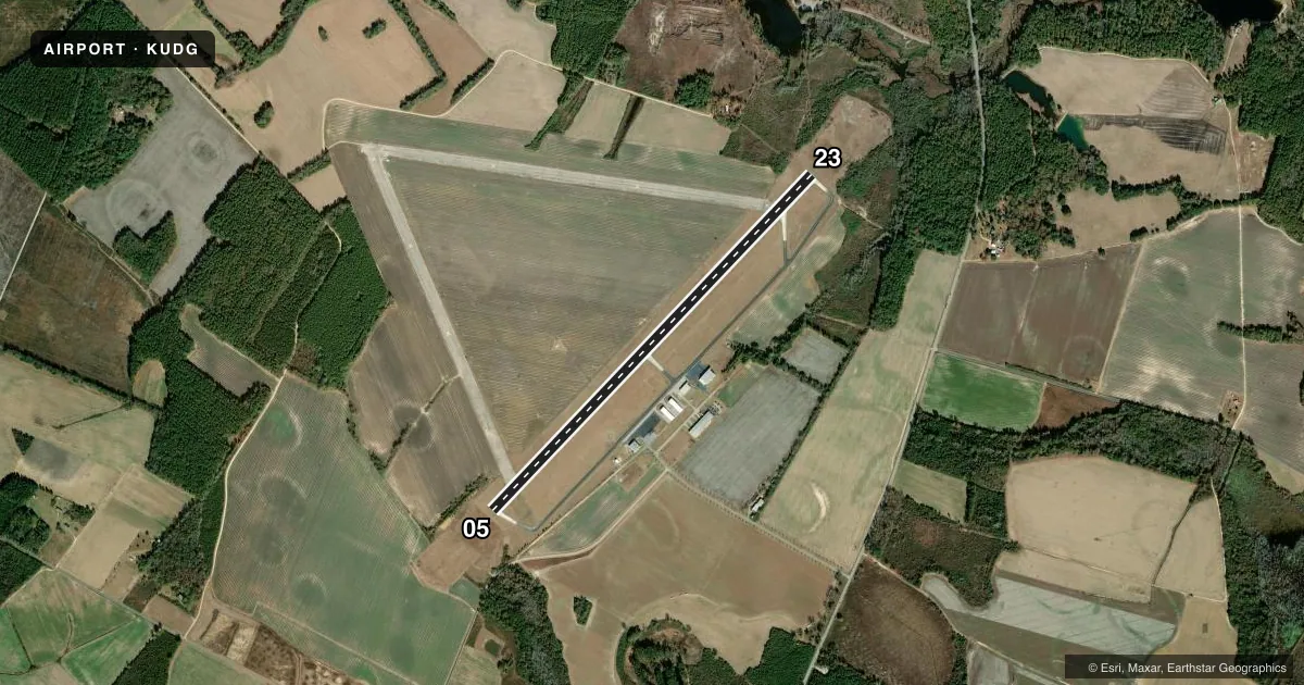
Runways & pattern
Full pagePattern entry · RWY 05
LEFT TRAFFICRunway end performance
| End | TORA | TODA | ASDA | LDA | VGSI | Approach lights | Obstruction |
|---|---|---|---|---|---|---|---|
| 05 | — | — | — | — | PAPI 2-box left(3°) | ODALS | — |
| 23 | — | — | — | — | PAPI 2-box left(3°) | — | — |
Declared distances in feet. TORA = takeoff run available, TODA = takeoff distance, ASDA = accelerate-stop, LDA = landing distance.
Airport sketch
Runways drawn to scale from FAA survey coordinates, rendered over satellite imagery. Not for navigation.
Approaches & charts
Services on the field
Fuel grades, oxygen, maintenance, ramp storage and lighting — as declared to the FAA by the airport operator.
Fuel & services
- Fuel
- 100LLA
- Oxygen (bottled)
- Not available
- Oxygen (bulk)
- Not available
- Power plant repair
- Not available
Ramp & ground
- Transient storage
- Tie-down
- Hangar
- Landing fee
- No fee published
- Customs
- Not available
- Lighting schedule
- SEE RMK
- Beacon schedule
- SS-SR
- Beacon
- White / Green (civil land)(WG)
- Wind indicator
- Yes
- Segmented circle
- Yes
Fuel & FBOs
Cheapest 100LL and Jet A on the field and nearby. Always confirm with the FBO before taxi.
Airport notes
Surface conditions, obstructions, local procedures, lighting outages and other notes published with each FAA cycle.
General notes
- AFTER HRS SERVICE CALL 843-393-9928.
- FOR CD CTC FLORENCE APCH AT 843-665-0632, WHEN APCH CLSD CTC JACKSONVILLE ARTCC AT 904-845-1592.
Lighting notes
- ODALS RWY 05; MIRL RWY 05/23; AND TWY LGTS PRESET LOW INTST DUSK-2300; TO INCR INTST - CTAF. AFT 2300, ACTVT ODALS RWY 05; REIL RWY 05 & 23; PAPI RWY 05 & 23; MIRL RWY 05/23; AND TWY LGTS - CTAF.
Other notes
- ARPT EXISTED PRIOR TO 1958.
VFR map & nearby airports
VFR sectional. Tap any ICAO chip to open that airport.
Key facts · KUDG
Answer card- ICAO
- KUDG
- Name
- DARLINGTON COUNTY
- Location
- DARLINGTON, SOUTH CAROLINA
- Elevation
- 192.2 ft MSL
- Traffic pattern altitude
- 1,192.2 ft MSL (1,000 AGL)
- Control tower
- Non-towered (use CTAF)
- Total runways
- 1
- Longest runway
- 05/23 · 5,500 ft
- Published ILS approaches
- 0
- Published frequencies
- 5
- Magnetic variation
- 6°
- Current flight rules
- MVFR
- Current wind
- 000° at 0 kt
- Favored runway now
- –
Darlington County Airport sits in Darlington, South Carolina. Field elevation is 192.2 ft MSL. The airport has one runway. Runway 05/23 is 5,500 ft long with a concrete surface. There is no control tower. Pattern altitude is not published. Use the standard 1,000 ft AGL pattern for light piston traffic unless the current Chart Supplement says otherwise.
No ILS approaches are published here. The airport uses CTAF 123.0 and UNICOM 123.0. Florence Approach handles clearance delivery and approach services when available. If approach is closed, contact Jacksonville ARTCC. The field has one on-field FBO. Darlington County Airport is on the field. It carries 100LL, Jet A and Jet A Prist. After-hours service is available by phone.
The lighting setup matters here. Runway 05 has an omnidirectional approach lighting system. Runway 05 and 23 have medium intensity runway lights. Taxiway lights are preset low from dusk to 2300. Use CTAF to raise intensity. After 2300, the approach lights, runway end identifier lights, precision approach path indicators, runway lights and taxiway lights are all activated through CTAF. For a first-time arrival, plan for an uncontrolled field with published lighting procedures. Check the current Chart Supplement for any additional local procedures before you go.