METAR & TAF 2Q0
2Q0 does not publish a METAR.
Showing the nearest reporting station: KHVS (HARTSVILLE RGNL) · 2.9 NM away. Conditions at 2Q0 may differ.
METAR · KHVS
Observed 06:15Z
KHVS 270615Z AUTO 00000KT 4SM BR CLR 22/22 A2987 RMK AO2 LTG DSNT E AND W
- Wind
- 000° @ 0 kt
- Visibility
- 4 SM
- Temp / Dew
- 22°C / 22°C
- Altimeter
- 29.87 inHg
- Clouds
- CLR
- Density alt
- 1,264 ft
- Ceiling
- Unlimited
- Rules
- MVFR
Airport info & contacts
Manager on record, flight service, ARTCC, attendance schedule and pattern altitude — published by the FAA and refreshed every 28 days.
Location
- From city
- 4 NM N
- VFR sectional
- CHARLOTTE
- ARTCC
- ZJX · JACKSONVILLE
- NOTAM facility
- AND
Airport manager
- Name
- FLYING W
- Phone
- 843-307-3503
- Address
- 2020 OUSLEYDALE RD, HARTSVILLE SC 29550
Flight service · Hours
- FSS AND
- ANDERSON1-800-WX-BRIEF
Frequencies
Tap any row to copy the frequency to your clipboard.
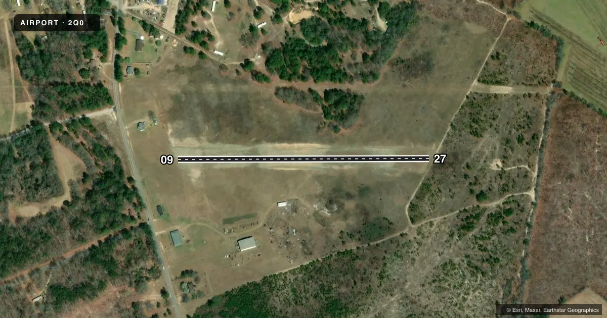
Runways & pattern
Full pagePattern entry · RWY 09
LEFT TRAFFICAirport sketch
Runways drawn to scale from FAA survey coordinates, rendered over satellite imagery. Not for navigation.
Approaches & charts
Services on the field
Fuel grades, oxygen, maintenance, ramp storage and lighting — as declared to the FAA by the airport operator.
Fuel & services
- Fuel
- Not available
Ramp & ground
- Transient storage
- Not published
Fuel & FBOs
Cheapest 100LL and Jet A on the field and nearby. Always confirm with the FBO before taxi.
Airport notes
Surface conditions, obstructions, local procedures, lighting outages and other notes published with each FAA cycle.
VFR map & nearby airports
VFR sectional. Tap any ICAO chip to open that airport.
Key facts · 2Q0
Answer card- ICAO
- 2Q0
- Name
- FLYING W
- Location
- HARTSVILLE, SOUTH CAROLINA
- Elevation
- 292 ft MSL
- Traffic pattern altitude
- 1,292 ft MSL (1,000 AGL)
- Control tower
- Non-towered (use CTAF)
- Total runways
- 1
- Longest runway
- 09/27 · 1,606 ft
- Published ILS approaches
- 0
- Published frequencies
- 1
- Magnetic variation
- –
- Current flight rules
- MVFR
- Current wind
- 000° at 0 kt
- Favored runway now
- –
FLYING W (2Q0) sits in Hartsville, South Carolina. Field elevation is 292 ft MSL. The airport has one runway. Runway 09/27 is a 1,606 ft turf strip with magnetic headings of 089.7809254541438 degrees and 269.780925454144 degrees. No tower is published, so pilots should plan to self-announce on CTAF 122.9 and keep a close scan in the pattern.
No ILS approaches are published here. Pattern altitude is not published, so use the standard 1,000 ft AGL pattern for light piston operations unless the current FAA Chart Supplement says otherwise. That puts the pattern at 1,292 ft MSL based on the field elevation. There are no on-field FBOs listed in the facts. Verify fuel and service availability with the airport operator or by calling the field directly before departure.
For a first-time arrival, the main things to know are the short turf runway and the lack of towered control. Check the runway surface condition before you go. Turf performance can change fast with rain or soft ground. With no published remarks and no ILS, this is a simple VFR field that still deserves a careful look at winds, density altitude and runway condition before you commit.