METAR & TAF 6J7
6J7 does not publish a METAR.
Showing the nearest reporting station: KUDG (DARLINGTON COUNTY) · 10.2 NM away. Conditions at 6J7 may differ.
METAR · KUDG
Observed 05:56Z
KUDG 270556Z AUTO 00000KT 7SM CLR 23/23 A2989 RMK AO2 SLP120 T02330233 10272 20233 58006 $
- Wind
- 000° @ 0 kt
- Visibility
- 7 SM
- Temp / Dew
- 23°C / 23°C
- Altimeter
- 29.89 inHg
- Clouds
- CLR
- Density alt
- 1,203 ft
- Ceiling
- Unlimited
- Rules
- VFR
Airport info & contacts
Manager on record, flight service, ARTCC, attendance schedule and pattern altitude — published by the FAA and refreshed every 28 days.
Location
- From city
- 3 NM SW
- VFR sectional
- CHARLOTTE
- ARTCC
- ZJX · JACKSONVILLE
- NOTAM facility
- AND (NOTAM-D)
Airport manager
- Name
- DWAYNE WEATHERFORD
- Phone
- 843-307-0070
- Address
- N. 46 CREEKVIEW DRIVE, DARLINGTON SC 29540
Flight service · Hours
- FSS AND
- ANDERSON1-800-WX-BRIEF
- Attendance
- Unattended
Frequencies
Tap any row to copy the frequency to your clipboard.
Runways & pattern
Full pagePattern entry · RWY 16
RIGHT TRAFFICRunway end performance
| End | TORA | TODA | ASDA | LDA | VGSI | Approach lights | Obstruction |
|---|---|---|---|---|---|---|---|
| 16 | — | — | — | — | VASI 2-box left | — | 65', trees, 528' from thr, 100' R of cntrln, slope 8 |
| 34 | — | — | — | — | VASI 2-box left(4°) | — | 15', road, 0' from thr, 0' R of cntrln, slope 0 |
Declared distances in feet. TORA = takeoff run available, TODA = takeoff distance, ASDA = accelerate-stop, LDA = landing distance.
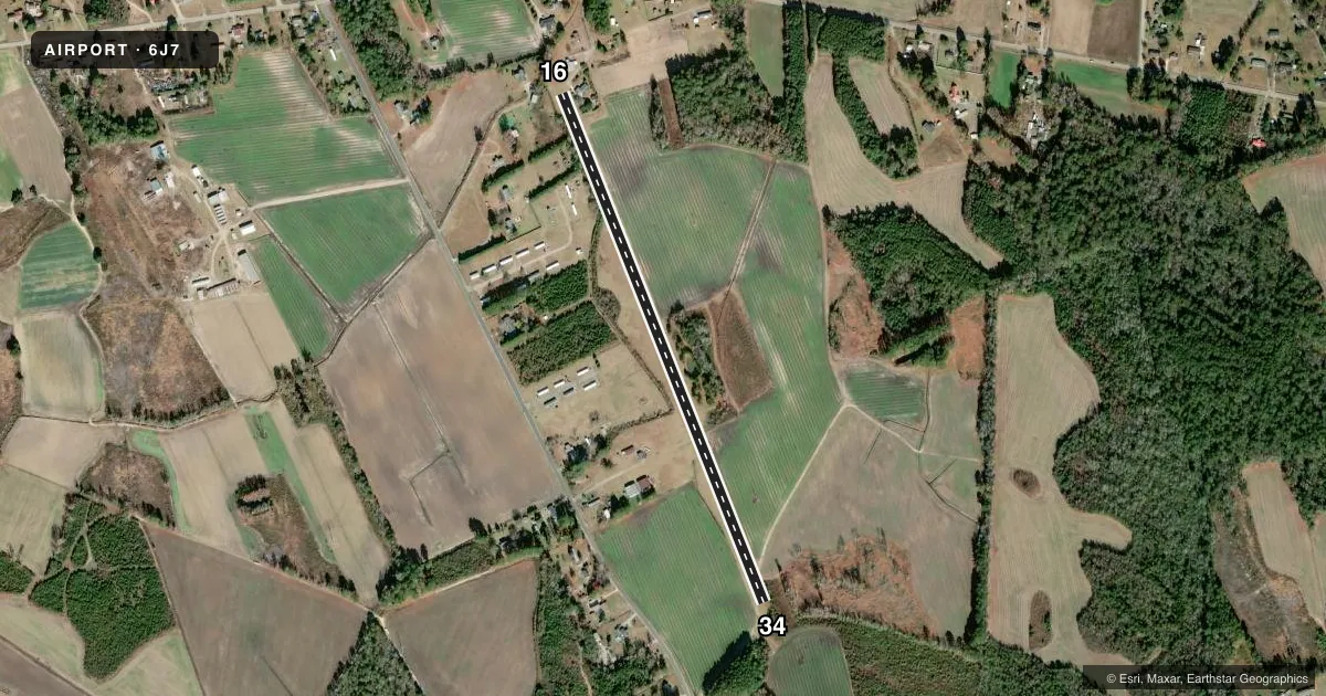
Airport sketch
Runways drawn to scale from FAA survey coordinates, rendered over satellite imagery. Not for navigation.
Approaches & charts
Services on the field
Fuel grades, oxygen, maintenance, ramp storage and lighting — as declared to the FAA by the airport operator.
Fuel & services
- Fuel
- Not available
- Oxygen (bottled)
- Not available
- Oxygen (bulk)
- Not available
- Airframe repair
- Minor
- Power plant repair
- Minor
- Other services
- INSTR
Ramp & ground
- Transient storage
- Tie-down
- Landing fee
- No fee published
- Customs
- Not available
- Lighting schedule
- SEE RMK
- Beacon schedule
- SEE RMK
- Beacon
- White / Green (civil land)(WG)
- Wind indicator
- Yes
- Segmented circle
- No
Fuel & FBOs
Cheapest 100LL and Jet A on the field and nearby. Always confirm with the FBO before taxi.
Airport notes
Surface conditions, obstructions, local procedures, lighting outages and other notes published with each FAA cycle.
General notes
- FOR CD CTC FLORENCE APCH AT 843-665-0632, WHEN APCH CLSD CTC JACKSONVILLE ARTCC AT 904-845-1592.
Lighting notes
- ARPT ROTG BCN OTS INDEFLY.
- ACTVT VASI RWY 16 & 34; LIRL RWY 16/34 - CTAF.
Approach & departure obstructions
- 16MULT CLOSE IN OBSTNS TO BOTH ENDS OF RWY. HOUSES AND TREES.
- 16RWY 16 HAS RIGHT TRAFFIC ONLY.
- 16BLDGS 70 FT LEFT & 125 FT RIGHT AT END OF THR.
- 34RWY 34 HAS DIRT ROAD RUNNING THROUGH THE RPZ AT THE THR.
Other notes
- VFR OPNS ONLY; ALL TURNS TO BE MADE W OF ARPT.
- 1ON CALL: 803-467-6941.
- 16/34SLIGHTLY BUMPY IN SOME AREAS.
VFR map & nearby airports
VFR sectional. Tap any ICAO chip to open that airport.
Key facts · 6J7
Answer card- ICAO
- 6J7
- Name
- BRANHAMS
- Location
- DARLINGTON, SOUTH CAROLINA
- Elevation
- 166 ft MSL
- Traffic pattern altitude
- 1,166 ft MSL (1,000 AGL)
- Control tower
- Non-towered (use CTAF)
- Total runways
- 1
- Longest runway
- 16/34 · 3,200 ft
- Published ILS approaches
- 0
- Published frequencies
- 1
- Magnetic variation
- 6°
- Current flight rules
- VFR
- Current wind
- 000° at 0 kt
- Favored runway now
- –
Branhams is in Darlington, South Carolina. Field elevation is 166 ft MSL. The airport has one runway. Runway 16/34 is 3,200 ft of turf, which is the longest runway on the field. There is no control tower. CTAF is 122.9. No ILS approaches are published here.
Pattern altitude is not published. Use the standard 1,000 ft AGL for light piston planning unless the current Chart Supplement says otherwise. The field is VFR only. All turns must be made west of the airport. Runway 16 is right traffic only. That matters here because the published remarks also call out close-in houses and trees near both ends. Runway 34 has a dirt road in the runway protection zone at the threshold. The runway surface is also slightly bumpy in some areas.
The airport rotating beacon is out of service indefinitely. Visual approach slope indicators are activated for runways 16 and 34. Low intensity runway lights are controlled by CTAF. No on-field FBOs are listed. Airport attendance is on call. For clearance delivery, contact Florence Approach. When approach is closed, contact Jacksonville ARTCC. If you are planning a first visit, review the current Chart Supplement before departure and expect a quiet turf field with some operational constraints.