METAR & TAF KBBP
Current METAR
Observed 06:40Z
KBBP 270640Z AUTO 00000KT 5SM BR CLR 22/22 A2986 RMK AO2
- Wind
- 000° @ 0 kt
- Visibility
- 5 SM
- Temp / Dew
- 22°C / 22°C
- Altimeter
- 29.86 inHg
- Clouds
- CLR
- Density alt
- 1,096 ft
- Ceiling
- Unlimited
- Rules
- MVFR
Airport info & contacts
Manager on record, flight service, ARTCC, attendance schedule and pattern altitude — published by the FAA and refreshed every 28 days.
Location
- From city
- 3 NM W
- VFR sectional
- CHARLOTTE
- ARTCC
- ZJX · JACKSONVILLE
- NOTAM facility
- AND (NOTAM-D)
Airport manager
- Name
- MR. BARRY AVENT
- Phone
- (843) 479-4797
- Address
- P.O. BOX 535, 1231 AIRPORT ROAD, BENNETTSVILLE SC 29512
Flight service · Hours
- FSS AND
- ANDERSON1-800-WX-BRIEF
- Attendance
- MON-SAT · 0800-1700
- SUN · 1300-1700
Frequencies
Tap any row to copy the frequency to your clipboard.
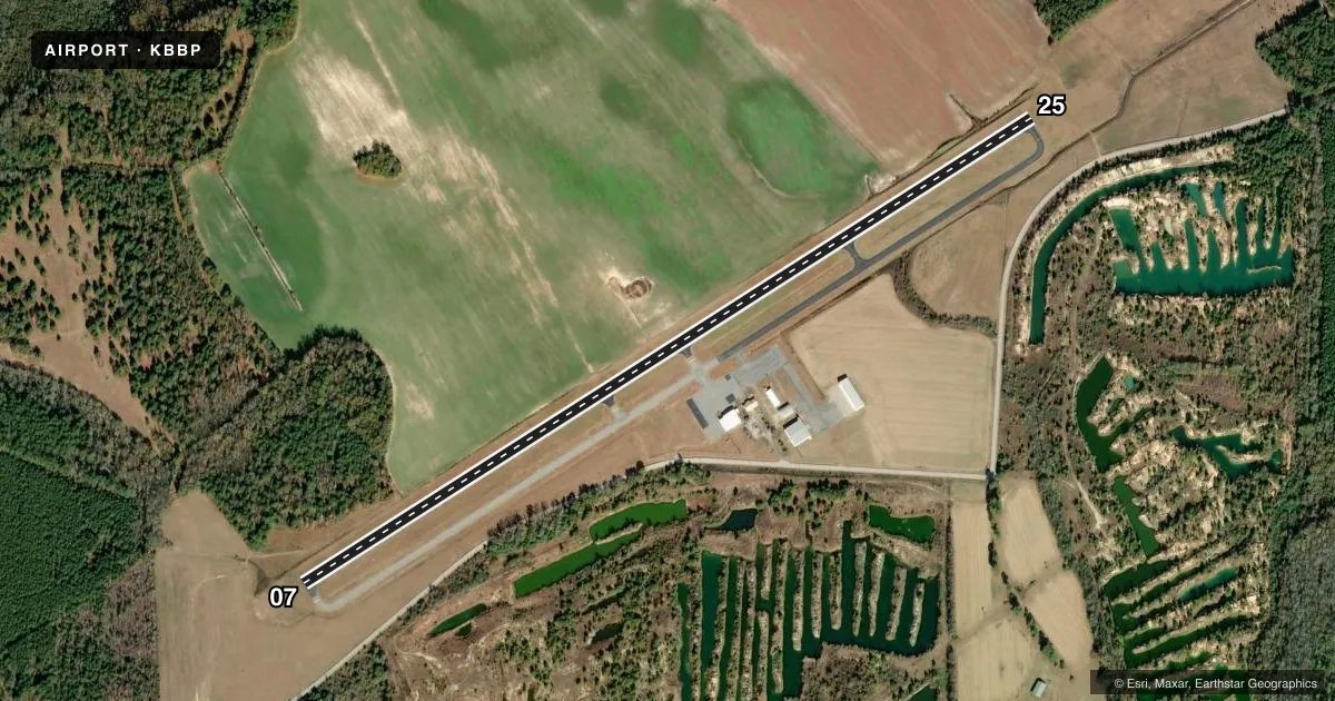
Runways & pattern
Full pagePattern entry · RWY 07
LEFT TRAFFICRunway end performance
| End | TORA | TODA | ASDA | LDA | VGSI | Approach lights | Obstruction |
|---|---|---|---|---|---|---|---|
| 07 | — | — | — | — | PAPI 2-box left(3°) | — | 82', tree, 2299' from thr, 359' R of cntrln, slope 25 |
| 25 | — | — | — | — | PAPI 2-box left(3°) | — | 88', tree, 2574' from thr, 384' R of cntrln, slope 26 |
Declared distances in feet. TORA = takeoff run available, TODA = takeoff distance, ASDA = accelerate-stop, LDA = landing distance.
Airport sketch
Runways drawn to scale from FAA survey coordinates, rendered over satellite imagery. Not for navigation.
Approaches & charts
Services on the field
Fuel grades, oxygen, maintenance, ramp storage and lighting — as declared to the FAA by the airport operator.
Fuel & services
- Fuel
- 100LLA
- Oxygen (bottled)
- Not available
- Oxygen (bulk)
- Not available
- Airframe repair
- Not available
- Power plant repair
- Not available
Ramp & ground
- Transient storage
- Tie-down
- Hangar
- Landing fee
- No fee published
- Customs
- Not available
- Lighting schedule
- SS-SR
- Beacon schedule
- SS-SR
- Beacon
- White / Green (civil land)(WG)
- Wind indicator
- Lighted
- Segmented circle
- Yes
Fuel & FBOs
Cheapest 100LL and Jet A on the field and nearby. Always confirm with the FBO before taxi.
Airport notes
Surface conditions, obstructions, local procedures, lighting outages and other notes published with each FAA cycle.
General notes
- FOR FBO MGR BARRY AVENT CALL (843)479-4797.
- FOR CD CTC FLORENCE APCH AT 843-665-0632, WHEN APCH CLSD CTC JACKSONVILLE ARTCC AT 904-845-1592.
Fuel notes
- 100LLFOR FUEL AFTER HRS CALL 843-862-4359.
Other notes
- RWY 16/34 LIMITED TO OPERATIONS IN VFR WX CONDS.
- 3FOR SVC SUN CALL FBO 843-454-2303.
- MANAGERCOUNTY ADMINISTRATOR.
VFR map & nearby airports
VFR sectional. Tap any ICAO chip to open that airport.
Key facts · KBBP
Answer card- ICAO
- KBBP
- Name
- MARLBORO COUNTY JETPORT/H E AVENT FLD
- Location
- BENNETTSVILLE, SOUTH CAROLINA
- Elevation
- 146.8 ft MSL
- Traffic pattern altitude
- 1,146.8 ft MSL (1,000 AGL)
- Control tower
- Non-towered (use CTAF)
- Total runways
- 1
- Longest runway
- 07/25 · 5,003 ft
- Published ILS approaches
- 0
- Published frequencies
- 4
- Magnetic variation
- 8°
- Current flight rules
- MVFR
- Current wind
- 000° at 0 kt
- Favored runway now
- –
Marlboro County Jetport/H E Avent Fld sits in Bennettsville, South Carolina. Field elevation is 146.8 ft MSL. The airport has one runway, 07/25, which is 5,003 ft long. There is no control tower. No ILS approaches are published here. The pattern altitude is not published, so use the standard 1,000 ft AGL for light piston operations unless the current Chart Supplement says otherwise.
Rare Air is on the field. It carries 100LL and Jet A. For fuel after hours, the published remarks give a phone number for help. The remarks also say to contact Florence Approach for clearance delivery. If approach is closed, Jacksonville ARTCC is the backup contact. That matters if you are planning an IFR arrival or departure.
This is a non-towered field with published approach control support from Florence. Keep an eye on CTAF 122.8 for local traffic. The airport sits in the Bennettsville area, so plan for a straightforward low-elevation arrival. If you need anything operational that is not listed here, check the current FAA Chart Supplement or call the airport operator or FBO directly before you go.