METAR & TAF KMEB
Current METAR
Observed 08:52Z
KMEB 270852Z AUTO 00000KT 4SM BR CLR 22/22 A2985 RMK AO2 SLP106 T02170217 56013
- Wind
- 000° @ 0 kt
- Visibility
- 4 SM
- Temp / Dew
- 22°C / 22°C
- Altimeter
- 29.85 inHg
- Clouds
- CLR
- Density alt
- 1,194 ft
- Ceiling
- Unlimited
- Rules
- MVFR
Airport info & contacts
Manager on record, flight service, ARTCC, attendance schedule and pattern altitude — published by the FAA and refreshed every 28 days.
Location
- From city
- 3 NM N
- VFR sectional
- CHARLOTTE
- ARTCC
- ZDC · WASHINGTON
- NOTAM facility
- MEB (NOTAM-D)
Airport manager
- Name
- SETH HATCHELL
- Phone
- 910-390-6122
- Address
- 16701 AIRPORT RD, MAXTON NC 28364
Flight service · Hours
- FSS RDU
- RALEIGH1-800-WX-BRIEF
- Attendance
- MON - FRI · 0800-1800
- SAT - SUN · 0900-1700
Frequencies
Tap any row to copy the frequency to your clipboard.
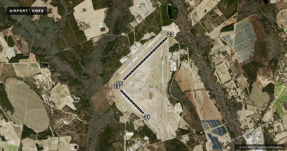
Runways & pattern
Full pagePattern entry · RWY 05
LEFT TRAFFIC| Runway | Heading (°M) | Length | Surface | Traffic |
|---|---|---|---|---|
| 05/23 | 38° / 218° | 6,503 ft | ASPH | 23 R |
| 13/31 | 127° / 307° | 3,536 ft | CONC | 13 R |
Runway end performance
| End | TORA | TODA | ASDA | LDA | VGSI | Approach lights | Obstruction |
|---|---|---|---|---|---|---|---|
| 05 | — | — | — | — | PAPI 4-box left(3°) | MALSR | — |
| 23 | — | — | — | — | PAPI 4-box left(3°) | — | 20', road, 534' from thr, 0' R of cntrln, slope 16 |
| 13 | — | — | — | — | — | — | 44', trees, 1721' from thr, 87' R of cntrln, slope 34 |
| 31 | — | — | — | — | — | — | 45', trees, 749' from thr, 294' R of cntrln, slope 12 |
Declared distances in feet. TORA = takeoff run available, TODA = takeoff distance, ASDA = accelerate-stop, LDA = landing distance.
Airport sketch
Runways drawn to scale from FAA survey coordinates, rendered over satellite imagery. Not for navigation.
Approaches & charts
ILS · 1
Services on the field
Fuel grades, oxygen, maintenance, ramp storage and lighting — as declared to the FAA by the airport operator.
Fuel & services
- Fuel
- 100LLA1+
- Oxygen (bottled)
- Not available
- Oxygen (bulk)
- Not available
- Airframe repair
- Minor
- Power plant repair
- Minor
- Other services
- AMB,INSTR,PAJA,RNTL
Ramp & ground
- Transient storage
- Tie-down
- Hangar
- Landing fee
- No fee published
- Customs
- Not available
- Lighting schedule
- SEE RMK
- Beacon schedule
- SS-SR
- Beacon
- White / Green (civil land)(WG)
- Wind indicator
- Lighted
- Segmented circle
- Yes
Fuel & FBOs
Cheapest 100LL and Jet A on the field and nearby. Always confirm with the FBO before taxi.
Airport notes
Surface conditions, obstructions, local procedures, lighting outages and other notes published with each FAA cycle.
General notes
- MIL ACFT FRQLY OPER FM CLSD PTN OF RWY 13/31 & CLSD RWY 18/36.
- HVY PAJA AT SOUTH END OF CLSD RWY 18/36 & SOUTH SIDE RWY 13/31.
- FARMING EQPT AND MIL OPS ON & INVOF ARPT.
- RWY 13/31 DALGT USE ONLY.
- NO LN OF SIGHT BTN RWY ENDS.
- FOR CD IF UNA VIA GCO CTC FAYETTEVILLE APCH AT 910-484-8012.
Lighting notes
- ACTVT MALSR RWY 05; PAPI RWY 05 & 23; HIRL RWY 05/23 - CTAF.
Fuel notes
- 100LL24 HR SELF SVC WITH CREDIT CARD.
Runway surface & condition
- 13/312750 FT CONC STOPWAY ON SE END.
Other notes
- CTC AMGR FOR ACFT RPR SVC.
- EXISTED PRIOR TO 1959.
- 1FOR SVC AFT HRS CALL 910-390-6122 OR 315-807-4759.
VFR map & nearby airports
VFR sectional. Tap any ICAO chip to open that airport.
Key facts · KMEB
Answer card- ICAO
- KMEB
- Name
- LAURINBURG/MAXTON
- Location
- MAXTON, NORTH CAROLINA
- Elevation
- 215.6 ft MSL
- Traffic pattern altitude
- 1,215.6 ft MSL (1,000 AGL)
- Control tower
- Non-towered (use CTAF)
- Total runways
- 2
- Longest runway
- 05/23 · 6,503 ft
- Published ILS approaches
- 1
- Published frequencies
- 4
- Magnetic variation
- 8°
- Current flight rules
- MVFR
- Current wind
- 000° at 0 kt
- Favored runway now
- –
Laurinburg/Maxton Airport (KMEB) sits in Maxton, North Carolina. The field elevation is 215.6 ft MSL. It has two runways. The longest is runway 05/23 at 6,503 ft. Runway 13/31 is 3,536 ft and is for daylight use only. There is no control tower. CTAF and UNICOM are both 122.8. Fayetteville Approach handles the published approach and departure frequencies.
Runway 05 has an ILS. MALSR is active on runway 05. PAPI is published for runways 05 and 23. High intensity runway lighting is on runway 05/23. The published pattern altitude is not listed, so use the standard 1,000 ft AGL for light piston operations unless the current Chart Supplement says otherwise. That puts the pattern at about 1,216 ft MSL based on field elevation.
Southeast Regional Airport is on the field. It carries 100LL and Jet A with Prist. 100LL is available 24 hours self-serve with credit card. There is also after-hours service contact info in the Chart Supplement. First-time visitors should pay attention to the published remarks. Farming equipment and military traffic are reported in and around the airport. Military aircraft also frequently use the closed portions of runway 13/31 and 18/36. There is no line of sight between runway ends, so get clear taxi and runway awareness before moving out.